

Historic Flooding Continues in Arklatex

Impressive rainfall totals from this week across the Arklatex.
The horrible flooding saga continues in the Arklatex.
The levee on Red Chute Bayou in northeastern Shreveport is about to be overtopped. Over one half mile of levee is in danger of being topped. The water level at Dogwood is still rising. Official are urging residents in several neighborhoods to get out before the water rushes in.
More heavy rain is moving across northwestern Louisiana at this hour, which will exacerbate the flooding.
There are still numerous road closures in Louisiana according to the Louisiana Department of Transportation. I-20 is closed westbound east of Minden and I-49 is closed in both directions just south of Shreveport because of flooding. LA-167, an important artery between Alexandria and Ruston, is closed in several locations and LA-165 is closed just south of Monroe.
Here is a link to the Louisiana 511 Cameras, Roadwork, Road Reports, Weather Warnings and Ferry Status Page.
https://hb.511la.org/#cameras/albumView/344?timeFrame=TODAY&layers=allReports%2Croadwork%2CroadReports%2CweatherWarnings%2CferryReports%2Ccameras
20.29 inches of rain has fallen since Tuesday at the Ruston Regional Airport. Another 1.31 inches has fallen today. It is already the wettest month on record there with nearly 20 days to go!
A CoCORaHS rainfall observer 2.4 miles NNW of Monroe has 8.46” on the 8th, 12” on the 9th and 2.76” on the 10th for a storm total of 23.22 inches!
It will easily be the wettest March on record at Shreveport. They have recorded 11.43 inches through midnight with another 0.22 through 10 a.m. and more moderate rain moving into area from the southwest. Their all time March monthly record is 11.99 inches. Their all time monthly record is probably safe however: 21.84 in April 1991. The 10.44 inches that occurred on the 12th of that month is their all time wettest day.
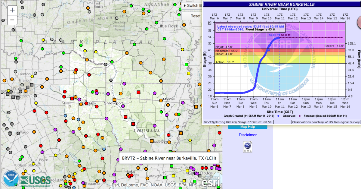
Now huge flooding on the Sabine River is about to get worse. The Toledo Bend Dam on the Texas/Louisiana border is now releasing 207,000 cubic feet per second, which is 30% above the record release last summer after Tropical Storm Bill! There will be record flooding south of the dam.
Click image to enlarge.
The catastrophic rains are the result of a power upper trough that dug all the way down into northern Mexico, bringing rare snows to Mexico City. It was their first snwfall since 1967! The system has pumped copious amounts of rich Gulf of Mexico moisture northward into the Arklatex. The system has had its forward progress blocked by a strong Bermuda high off the U.S. East Coast, allowing the impressive rains to pile up.
The 2.12 inches of precipitable water at Slidell this morning on their balloon release smashed the previous record for the date of 1.62 inches.
Category: Headlines, Severe Weather
About the Author (Author Profile)
Bill Murray is the President of The Weather Factory. He is the site's official weather historian and a weekend forecaster. He also anchors the site's severe weather coverage. Bill Murray is the proud holder of National Weather Association Digital Seal #0001 @wxhistorianSubscribe
If you enjoyed this article, subscribe to receive more just like it.


