Staying Warm
For those who may be thinking about getting that Spring garden started with this extended warm spell, just a reminder that the average date of the last freeze for Birmingham is April 1st. And the latest freeze seen in Birmingham was April 23, 1986. So we still have some time left for the weather to turn colder again.
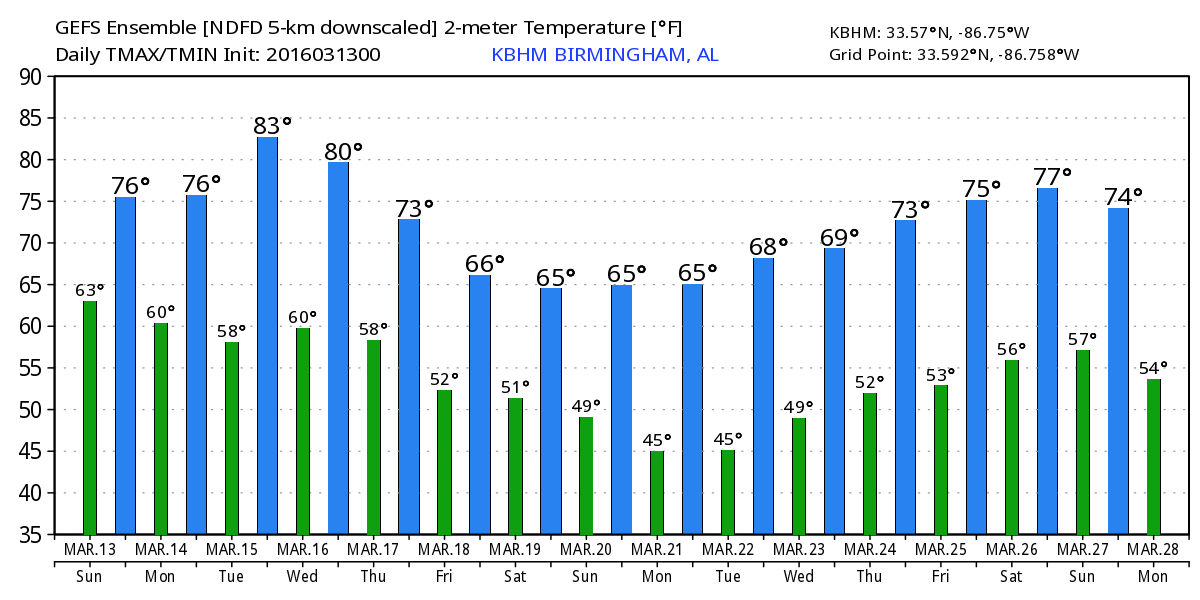
But for now, the warm trend continues. Highs, in spite of the clouds and rain, will continue to reach into the 70s. It looks like we may see a break in the wetness come Tuesday, and if that verifies, we may also see the warmest day so far for 2016 with highs into the lower 80s. Record high for that day for Birmingham is 84 set last in 2012. Other records include 86 in Tuscaloosa set in 1982, 83 in Anniston set in 2012, and 86 in Montgomery set in 1973.
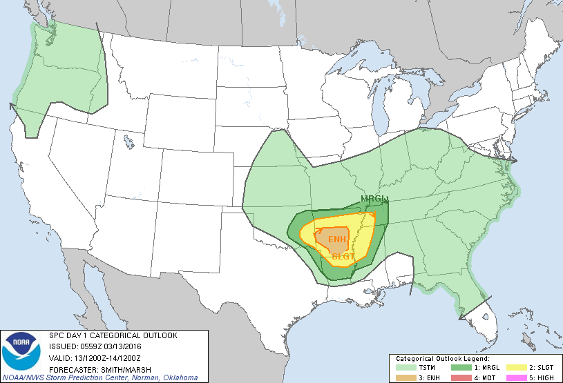
That big closed low responsible for the widespread flooding just to our west is finally ejecting out across the Ohio River Valley as another system dives into Oklahoma right behind it. This keeps the Southeast US and Central Alabama in a warm regime while setting up the potential for severe storms centered mainly on Arkansas for today and tonight according to SPC forecasts. The primary severe weather threats will be large hail and tornadoes. Looks like we stay mostly cloudy but some peeks at the sun are possible. Showers may occur this morning, but we should stay mostly dry for the afternoon. Some fog may be an issue this morning, but should burn off by 9 am or so.
By Monday, the upper low is moving by Alabama while the surface low moves off the Mid-Atlantic States. We may see some showers early Monday, but by late morning we should see things drying out with highs again in the 70s. Greatest risk for severe storms will come in an area centered on North Carolina.
Tuesday will be an in-between day. We’ll see weak ridging in the upper atmosphere as another trough digs into the Rockies. This should bring us a fairly nice day with sunshine returning and it may well be the warmest day so far in 2016. We’re projecting highs into the lower 80s, and as I noted above, 84 is the record high for Tuesday.
Wednesday the upper pattern begins to change as we develop a general troughiness over the eastern half of the US. The overall trough was deeper on the run yesterday, and this latest run of the GFS holds a nearly zonal flow across the southern tier of the US. With this pattern we will cool off some, but temperatures won’t fall back as much as we thought yesterday. We should still see temperatures for the latter half of the week into the 60s, but more in the upper 60s. Lows will correspondingly fall into the 40s but only the upper 40s. The 30-year average lows and highs for Birmingham are 43 and 66. So we should be closer to those typical values, but still warmer than average.
Toward the weekend, the GFS brings another strong upper trough out of the Rockies across the Lower Mississippi River Valley. This should make for a fairly wet weekend, though it is interesting to note the the GFS is much less bullish on the precipitation than the European is. By Sunday we should see temperatures fall closer to the 30-year averages with lows into the 40s and highs in the lower and middle 60s.
Looking out into week 2, the GFS forecasts another stout short wave trough to move by on the 23rd of March providing us with some wet and stormy weather. The weather stays tranquil for several days, but by the 27th of March, there is a closed low in the vicinity of Lake Charles, LA, and this pattern would spell a wet period for the Southeast US.
James Spann will be back with the next edition of the Weather Xtreme Video first thing on Monday morning. Don’t forget the next spotter training from ABC 3340 will be Tuesday beginning at 6:30 pm in Cullman at the Civic Center on 5th Street Southwest. Hope to see you there. Have a great day, and Godspeed.
-Brian-
Category: Alabama's Weather
About the Author (Author Profile)
Brian Peters is one of the television meteorologists at ABC3340 in Birmingham and a retired NWS Warning Coordination Meteorologist. He handles the weekend Weather Xtreme Videos and forecast discussion and is the Webmaster for the popular WeatherBrains podcast.Subscribe
If you enjoyed this article, subscribe to receive more just like it.


