Waking to a Chilly Morning
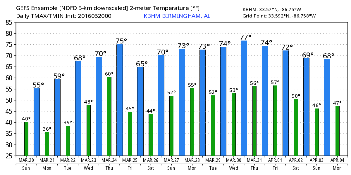
Spring has officially begun, but you sure can’t tell from the temperatures this morning. In fact, it is the coldest morning we’ve seen in about two weeks since the very first days of March. The sky is clear across nearly all of Alabama with the exception of clouds lingering across the southern strip of counties and a few clouds entering the northeast counties. Look for a good supply of sunshine today but temperatures will be a bit chilly with highs only in the 50s. And a fairly brisk north wind of 10 to 20 mph with some higher gusts will make it feel even colder.
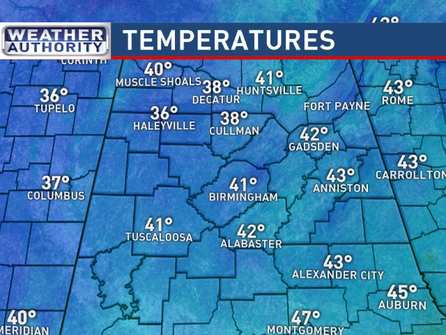
The upper trough will bottom out later this afternoon as high pressure settles into the Lower Mississippi River Valley. So it still looks like Monday morning will be our coldest morning, but there are still some uncertainties regarding frost formation. My main concern is that we may not see the wind go completely calm. The MOS guidance from the GFS and NAM are 35 and 34 respectively and both models show a 3 to 4 mph wind through the sunrise time. So I think the frost will not be widespread, but will still occur in those normally colder sheltered valley locations where the wind will have an opportunity to go calm due to terrain.
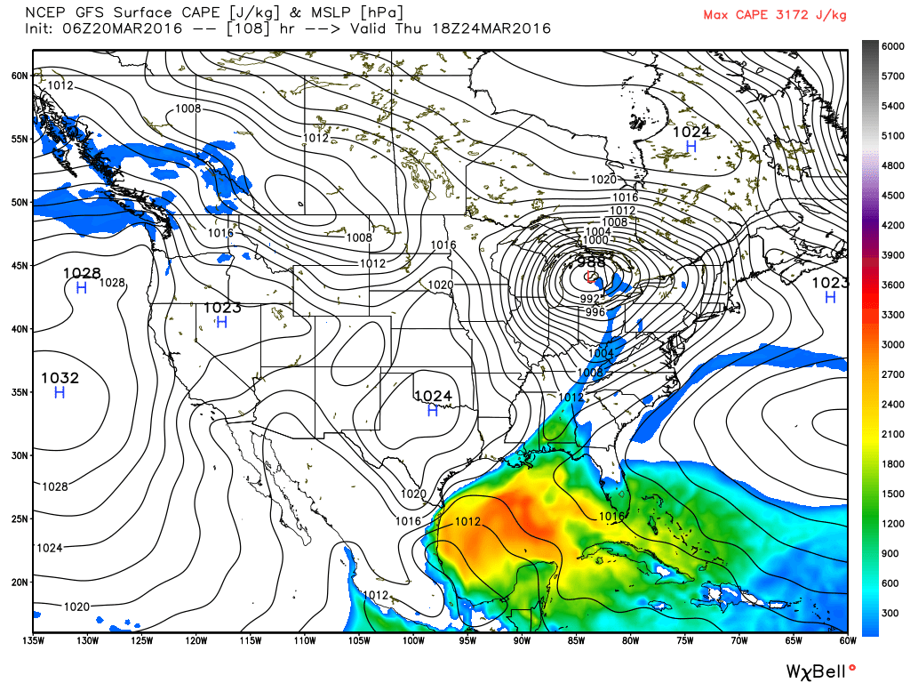
After the chilly morning Monday, we begin the warm up with an upper ridge over the eastern half of the country through Wednesday. This should allow temperatures to rise nicely into the 70s Tuesday and Wednesday. Wednesday we turn our attention to the development of another trough over the Rockies. This trough ejects across the Great Lakes on Thursday with a healthy 988 millibar surface low over the Michigan with a cold front trailing southwestward across the Ohio River Valley and Alabama into the Gulf of Mexico. This run is a little faster with this system then we saw yesterday, but it still seems likely that Wednesday will be dry with the main threat for rain coming on Thursday.
We are into March, so there is some concern for the potential for severe thunderstorms. CAPE values come up into the 1500 to 2000 j/kg range, however, it seems that most of the better dynamics with this system are well north of us. SPC does have an area outlined on Day 4, Wednesday into early Thursday, well west of us, and they mention Day 5 as having some potential but not currently reaching values sufficient for specific mentioning. So this will be one for us to maintain some vigilance on as we get closer to the event.
That trough moves quickly into southeastern Canada as our pattern goes nearly zonal. This means our temperatures should drop back a little but nothing nearly as cold as the current system. Highs should be in the 60s with lows in the 40s on Friday.
Next weekend’s forecast is some what problematic. The GFS suggests rain while the Euro is rain-free. The GFS suggests severe weather for Sunday while the Euro does not. So at this time, you can simply take your pick. I’m going to stick to the pattern suggested by the GFS which seems to be more in line with previous runs and shows a pattern more consistent with the time of year. So for Saturday it looks like we might see some clouds and light rain with the high pressure centered over southern New England creating a wedge pattern for Georgia and Alabama. The upper trough comes across the middle Mississippi River Valley on Sunday with a surface low in western Kentucky. This could well mean another round of severe storms for the Southeast US, but we are verging on voodoo country, so we cannot be too specific on details just yet. This scenario certainly provides great material for “stay tuned.”
Looking further afield, we see a weak upper ridge around the 30th of March followed by a fairly low latitude system around April 2nd. This certainly has the look of a potential severe weather setup. And that system is followed by another upper ridge around April 4th. Certainly no signs of anything extreme when it comes to temperature.
Thanks for staying tuned to the Weather Xtreme Video. James Spann will have the next edition right here on Monday morning. Enjoy a somewhat chilly Spring day and Godspeed.
-Brian-
Category: Alabama's Weather
About the Author (Author Profile)
Brian Peters is one of the television meteorologists at ABC3340 in Birmingham and a retired NWS Warning Coordination Meteorologist. He handles the weekend Weather Xtreme Videos and forecast discussion and is the Webmaster for the popular WeatherBrains podcast.Subscribe
If you enjoyed this article, subscribe to receive more just like it.


