

Strong Storms Possible Thursday
COLD MORNING: Our Skywatcher at Black Creek, just northeast of Gadsden, Vic Bell, reports 32 degrees early this morning… we are seeing 30s at places like Cullman and Haleyville. Another reminder you never plant anything that might be harmed by a freeze or frost until April 15.
Expect a big warm-up today; we rise into the 72-75 degree range this afternoon with a good supply of sunshine.
TOMORROW: The daytime hours will be dry with a mix of sun and clouds along with a high in the mid 70s. To the west, severe storms are possible by afternoon from the western Gulf Coast up to the cornbelt region, and showers and storms should begin to creep into our state late tomorrow night. The model guidance is slower, suggesting it will be after midnight before most places see any rain.
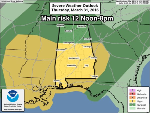
SEVERE WEATHER THREAT THURSDAY: SPC has defined the standard “slight risk” of severe storms Thursday south of a line from Millport to Birmingham to Anniston, with a “marginal risk” to the north.
A deep surface low will be over the Great Lakes with a trailing cold front slowly approaching Alabama from the west. It still looks like a situation where the system could be a little out of phase, with the higher instability values displaced west of the better dynamics. But if we see a break in the rain at some point during the morning or midday hours Thursday, that will make for even higher instability values during the afternoon, certainly opening the door for severe storms.
TIMING: The primary window for severe storms for now looks to be in the 12:00 noon to 8:00 p.m. time frame Thursday.
MODES: Stronger storms Thursday afternoon could produce hail and strong, possibly damaging winds. The tornado threat is somewhat conditional with the displacement between the higher instability and the low level jet/dynamic forcing.
FLOODING: One thing is certain; it will rain a good bit. Rain amounts of 2 inches are likely, with isolated amounts over three inches, and some flash flooding issues could develop by Thursday afternoon/evening.
Rain and storms will end Thursday night as drier air begins to push into the state.
FRIDAY: We will forecast a breezy day with gradual clearing. There could be a pretty sharp thermal contrast due to the passing cold front… Northwest Alabama will hold in the 50s, while areas south and east of Birmingham will rise into the 70s.
THE ALABAMA WEEKEND: Expect a bright, sunny sky Saturday and Sunday with pleasant days and cold nights. Early morning lows will drop into the 36-42 degree range Saturday and Sunday morning; highest frost potential will come early Sunday with a clear sky and light wind. I don’t think the frost will be especially widespread, but it is most likely across colder valleys. Growers will still need to monitor temperatures both mornings.
The high Saturday will be in the mid 60s, followed by upper 60s Sunday.
NEXT WEEK: Dry weather continues into the first half of next week with a warming trend; see the Weather Xtreme video for maps, graphics, and more details.
AT THE BEACH: Today will will be dry from Gulf Shores over to Panama City Beach, with a partly sunny sky. Clouds increase tomorrow, and showers and storms are likely Thursday and Friday. The weather will then trend drier over the weekend. Highs will be in the 70s, but only in the 60s on the immediate coast due to the cooler ocean water. The sea surface temperature early this morning at the Dauphin Island Sea Lab is 68 degrees. See a very detailed Gulf Coast forecast here.
STORM SPOTTER TRAINING: Storm Spotter Xtreme is coming up Saturday, April 9 at the BJCC from 9am to 2pm. This will feature both the basic and advanced SKYWARN classes, along with a session from Kevin Laws of the Birmingham NWS office. And, if you come, you get free admission to the Alabama International Auto Show, going on at the BJCC that same day. There is no cost and no need to register. Just show up with a curious mind. Kids 10 and older will also enjoy this if they love weather and want to learn more. Please help us make the severe weather warning process better!
We will have one more basic spotter training session at Helena (at the Civic Center) one week from tonight, on Tuesday April 2 at 6:30p.
WEATHER BRAINS: Don’t forget you can listen to our weekly 90 minute netcast anytime on the web, or on iTunes. This is the show all about weather featuring many familiar voices, including our meteorologists here at ABC 33/40. Scroll down for the show notes on the new episode we recorded last night.
CONNECT: You can find me on all of the major social networks…
Facebook
Twitter
Google Plus
Instagram
I will be doing a weather program for a home school group today at Trinity Presbyterian Church in Cahaba Heights… look for the next Weather Xtreme video here by 4:00 this afternoon. Enjoy the day!
Category: Alabama's Weather
About the Author (Author Profile)
James Spann is one of the most recognized and trusted television meteorologists in the industry. He holds the AMS CCM designation and television seals from the AMS and NWA. He is a past winner of the Broadcast Meteorologist of the Year from both professional organizations.Subscribe
If you enjoyed this article, subscribe to receive more just like it.


