Late Morning Notes
Still a good deal of uncertainty about how this event will unfold this afternoon and tonight. We may not know exactly until we see the whites of this system’s eyes.
Let’s peruse some data late this morning.
JETSTREAM LEVEL
Up at the jetstream level, the polar jet and the subtropical jet are trying to come together and have successfully merged into a powerful river of air up at about 35,000 feet, extending from northern Mexico across Texas and into Louisiana. They split again after that, which puts the Ohio and Tennessee Valleys in a divergent pattern aloft where the air is spreading apart. This means additional lift.
MID-LEVEL
An upper disturbance is near Nashville at this hour. To the south of it, showers an thunderstorms cover much of Northwest Alabama
LOW-LEVEL
The strong 850 millibar jet, up at about 5000 feet, has lifted with the disturbance into Tennessee. Storms over Northwest Alabama have weakened accordingly and not much lightning is being reported there. The only prospects for lightning right now are around Marion County, where tops are percolating up to around 30,000 feet, the magic zone for lightning production.
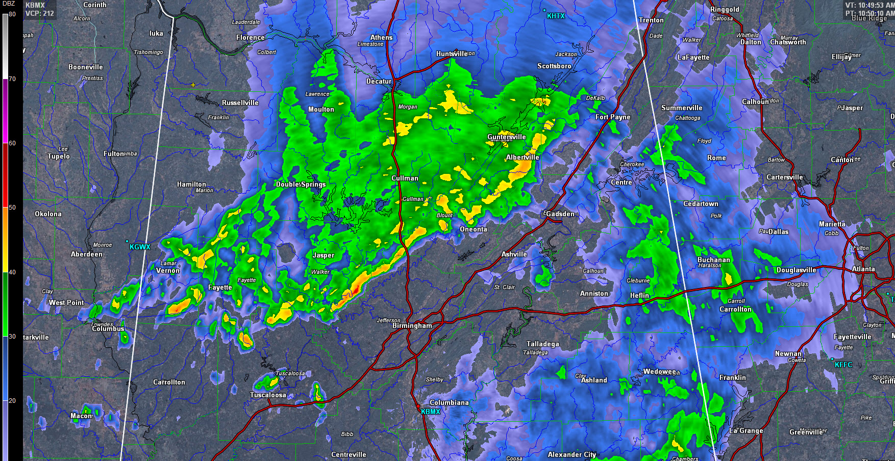
RADAR TRENDS
The southern flank of the showers is most active now, from the Columbus MS area across Lamar, Fayette and southern Walker Counties. This activity will begin to affect the Birmingham area within the hour, but will stay north of Tuscaloosa for the time being. With little or no instability, thunder will be limited at best.
BAD STORM IN SOUTHWEST ALABAMA
The storm over Southwest Alabama is near Macintosh. It will move toward Atmore and Brewton. Severe thunderstorm warnings are in effect. A tornado watch covers Southwest Alabama as well. Tops on that storm are approaching 50,000 feet.
CLEARING UPSTREAM
Breaks are beginning to appear in the clouds over Mississippi, Arkansas and Louisiana. Temperatures are all of Louisiana are now in the 70s, with 70 degree readings edging into western Mississippi. It’s currently 74F/72F (temp/dewpoint) at Alexandria LA and 76F/72F at Monroe. It is 75F/70F at Natchez MS. That is tropical air and extremely moist for late March. Dewpoints are 68F at Jackson MS and 65F already at Merdian. Here in Alabama, dewpoints are in the lower 60s and climbing. INstability values are already above 1,000 joules/kh with a maximum of 2,000 j/kg over Louisiana. This unstable air extends into southern Arkansas.
The main slug of moisture is now moving into Alabama, with some drying aloft behind it. This could enhance the severe weather threat later today and tonight.
COLD FRONT
Our cold front is past Dallas and is approaching the northwest corner of Arkansas. it will continue pushing eastward and should reach the Northwest corner of Alabama by midnight tonight. The surface low is 994 millibars this morning and is approaching Chicago.
CONVECTIVE INITIATION
Storms have already fired over northeastern Arkansas in the channel of warm air advection. These storms will move toward the Ohio valley including western Kentucky and northwestern Tennessee. LATE NOTE: A new severe thunderstorm watch just went up for Northeast Arkansas, southeastern Missouri, southwestern Kentucky and western Tennessee.
Storms may fire along the boundary left over from this morning’s convection across West Central Alabama by 3-4 p.m. They should have decent instability to work with.
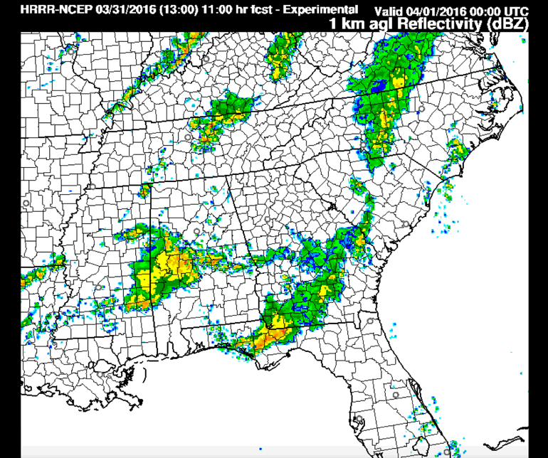
HRRR model radar depiction at 7 p.m. tonight.
Additionally, the main event should start to fire up near the Mississippi River around 3 p.m. and these storms will spread eastward. Additional storms may form over West Central Alabama by 6-7 p.m. as well. As many as three rounds of storms may spread across North and Central Alabama overnight. The moderately high instability values of the afternoon will wane after nightfall, but there will still be sufficient instability for severe weather through the night. Wind shear values will be sufficient for severe weather, including tornadoes as well.
VORTEX SE
Teams from the VORTEX SE Field Project are setting up today from Guin to Lawrenceburg TN with additional teams near Belle Mina AL and Boonville MS. They will be launching lots of special weather balloons. Not part of VORTEX SE, but the NWS BMX will be launching a special balloon around 19z or 20z (2 or 3 p.m. CDT) to sample the airmass as it recovers after the morning rain event.
FLOODING
Flash flood watches cover areas from Northeast Texas across southern Arkansas, northeastern Louisiana, all of Mississippi, southwestern Tennessee, almost all of Alabama, western NW Florida and into Central Georgia. Updated rainfall forecasts from the Weather Prediction center show 1.5 to 4 inches of rain across North Central Alabama with over 4 inches across most of South Alabama.
DROUGHT MONITOR
No drought worries. Only the extreme Northwest Corner of Alabama is even dry at this time.
Category: Alabama's Weather, Severe Weather
About the Author (Author Profile)
Bill Murray is the President of The Weather Factory. He is the site's official weather historian and a weekend forecaster. He also anchors the site's severe weather coverage. Bill Murray is the proud holder of National Weather Association Digital Seal #0001 @wxhistorianSubscribe
If you enjoyed this article, subscribe to receive more just like it.


