Watching to the West for a Watch
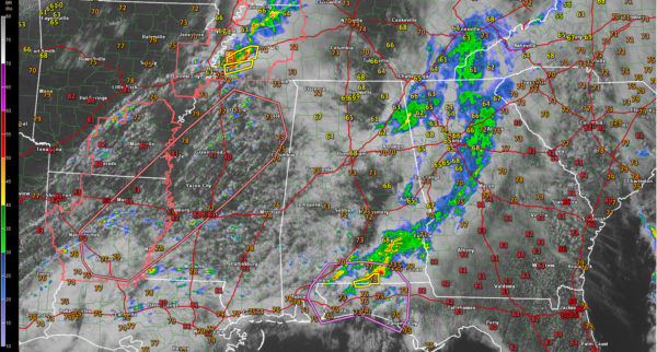
AND THE WATCH IS ISSUED: A new severe thunderstorm watch has just been issued for northern Louisiana and southeastern Arkansas. A tonrado watch will be forthcoming shortly for much of Mississippi.
EARLY AFTERNOON BREAK: We are in a bit of a break right now in this part of the state with the showers moving out of Northeast Alabama and continued storms over South Alabama. There will be some scattered showers around throughout the afternoon and evening until another line of thunderstorms will be making their way across the Alabama-Mississippi state line later this evening.
OMINOUS SIGNS TO THE WEST: Those breaks in the clouds over Mississippi and Louisiana have really heated things up. It is 81F this hour at Jackson MS and 82F at Vicksburg.
With dewpoints pushing 70F, the airmass is becoming quite unstable. Surface based CAPE values of 1,500-2,500 joules/kg are now widespread over Mississippi, with 500-1,000 joules already in place over West Central Alabama. There is no cap on the atmosphere and thunderstorm initiation will begin within the hour over Mississippi and northeastern Louisiana.
It is already 74F at Tuscaloosa and 71F at Calera. Clearing should work into the Birmingham area over the next hour or so allowing temperatures to reach into the 70s.
The only limiting factor for now are the low level lapse rates, which are weak. The mid level lapse rates are fairly robust though, so once convection gets going, it should develop fairly rapidly.
Bulk 0-6lm wind shear is 50–70 knots across Mississippi and Louisiana, which leaves no question that the storms will be able to stay organized and long lived.
An 850 mb jet will develop this evening over West Alabama as well, enhancing the shear as well.
Surface winds are out of the south southeast over northern Mississippi, northern Alabama and southern Tennessee, which would enhance the tornado threat. Low level helicity should will increase during the evening as the HRRR model hints that those surface winds will continue to back to the southeast over Central Alabama. Backed or southeasterly surface winds increase the tornado threat.
Additional storms may form over into Alabama along the instability boundary, but the main event will come when the storms arrive into Alabama from Mississippi.
I would expect that to occur between 6-8 p.m. Strong to severe storms will be widespread across North and Central Alabama until the wee hours of the morning.
According to the HRRR model, at 9PM, higher STP numbers are located over Fayette, Pickens, Greene, Sumter, Hale, and Tuscaloosa counties. There will be decent helicity over those areas, with enough instability to support updrafts and possible tornadoes.
The storms with those higher numbers will progress over the I-20 corridor in Tuscaloosa and Jefferson counties during the 10 PM-12 AM, with STP numbers near 3.6. By 12-1 AM, they will be reaching the Anniston and Oxford areas, and should be progressing out of the state by 2-3 AM.
All modes of severe weather should be possible, including tornadoes, damaging winds and hail. In fact, the hail threat is pretty significant, especially over Northwest Alabama.
HEAVY RAIN: That line of thunderstorms will be heavy, with rates as high as 2-3 inches per hour, so flash flooding will be a considerable risk. Flash flood watches remain in effect for all of Alabama except the Southeast corner.
WINDING DOWN: Most of the rain and thunderstorms should be out of north and central Alabama by 4-6AM. The latest run of the NAM is still showing a stalled boundary near the area, and that will actually keep rain chances up for places along and south of the I-59 corridor, with stronger storms staying confined to the southern half of the state and along the Gulf Coast.
Category: Alabama's Weather


