Severe Thunderstorm Warning – Greene and Pickens Counties Until 8:45 PM CDT
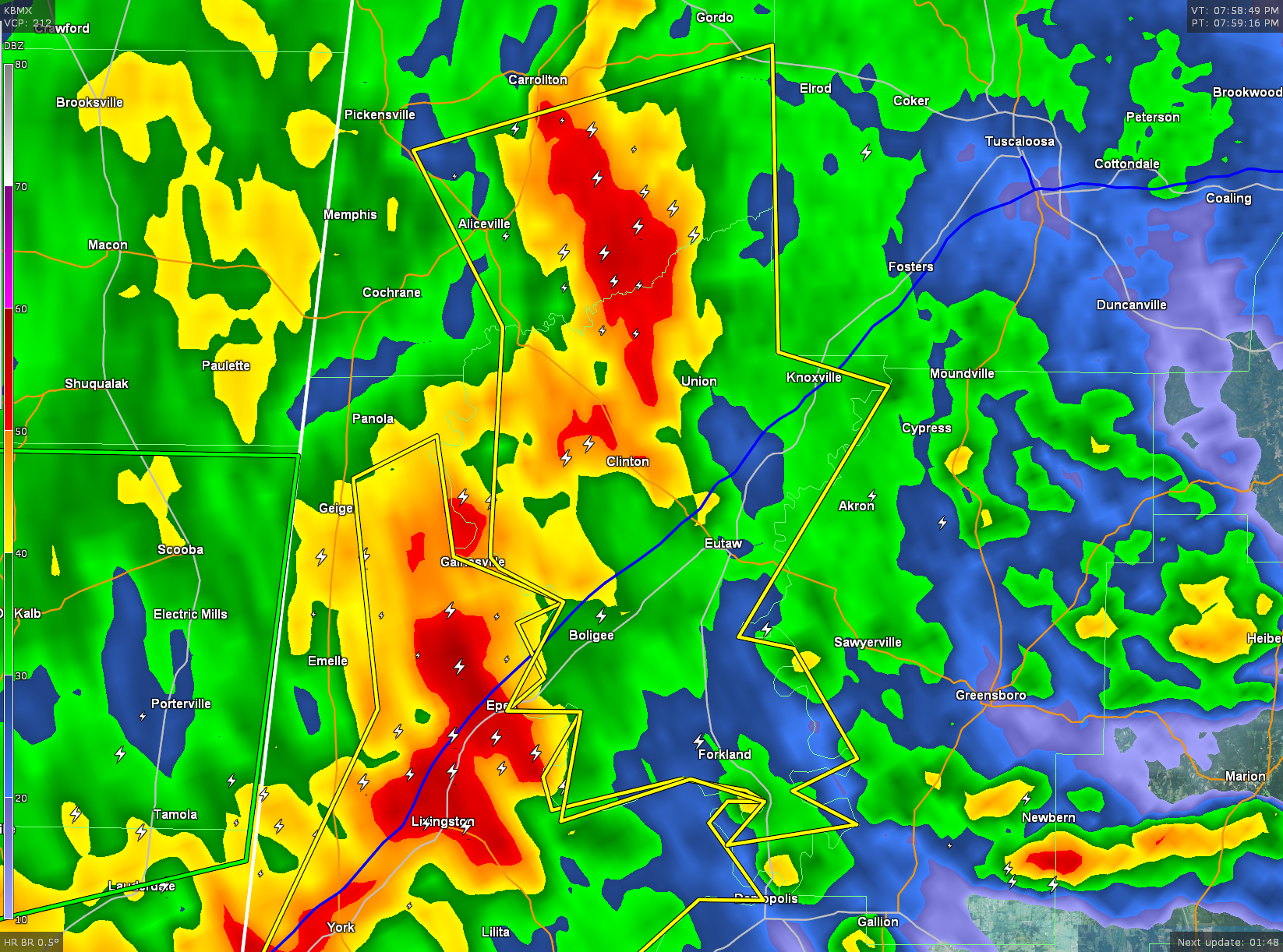
A Severe Thunderstorm Warning has been issued for until 8:45 PM CDT for southern Pickens County and Greene County. A line of severe thunderstorms are located along a line stretching from Carrollton to near Benevola. Line is moving to the east at 45 MPH. Locations in the path of this storm are listed below. If you are in the path of this storm, seek shelter immediately.
THE NATIONAL WEATHER SERVICE IN BIRMINGHAM HAS ISSUED A
* SEVERE THUNDERSTORM WARNING FOR…
SOUTHERN PICKENS COUNTY IN WEST CENTRAL ALABAMA…
GREENE COUNTY IN WEST CENTRAL ALABAMA…
* UNTIL 845 PM CDT
* AT 756 PM CDT…SEVERE THUNDERSTORMS WERE LOCATED ALONG A LINE
EXTENDING FROM CARROLLTON TO NEAR BENEVOLA TO NEAR BLUFFPORT…
MOVING EAST AT 45 MPH.
HAZARD…60 MPH WIND GUSTS.
SOURCE…RADAR INDICATED.
IMPACT…EXPECT DAMAGE TO ROOFS…SIDING…AND TREES.
* LOCATIONS IMPACTED INCLUDE…
EUTAW…ALICEVILLE…FORKLAND…BOLIGEE…UNION…EPES…MCMULLEN…NEW
WEST GREENE…JENA…DUFFYS BEND…BENEVOLA…THORNHILL…MANTUA…
ALLISON…KNOXVILLE…WALDEN QUARTERS…JOHNSTON LAKE…GARDEN…WEST
GREENE AND TISHABEE.
THIS INCLUDES INTERSTATE 20 BETWEEN MILE MARKERS 32 AND 52.
Category: Alabama's Weather, Severe Weather
About the Author (Author Profile)
Subscribe
If you enjoyed this article, subscribe to receive more just like it.


