Another Delightful Spring Day
BIG WARM-UP: We actually have some 30s over Northeast Alabama early this morning; Vic Bell at Black Creek reports 34 shortly before sunrise. But, the dry air over Alabama will warm up very nicely today, and most places will see a high in the mid 70s this afternoon with sunshine in full supply.
Tomorrow will be dry, but cooler, with a high in the mid 60s along with a sunny sky.
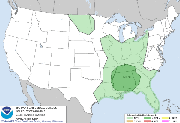
STRONG STORMS AT MID-WEEK: The weather during the day Wednesday will stay dry, but a cold front will bring a band of showers and storms in here Wednesday night, and some of those storms could be strong. SPC has defined a “marginal risk” of severe storms for much of Alabama…
The NAM model hints at surface based CAPE values (instability) rising to over 1,000 j/kg, and wind fields and shear values are sufficient for organized updrafts.
TIMING: The core window for storms will come from about 7:00 p.m. Wednesday through 3:00 a.m. Thursday.
MODES: The main threat will come from hail and gusty straight line winds. The tornado threat looks low at this point.
RAIN AMOUNTS: Totals of 1/2 to 3/4″ seem likely, not enough for flooding issues.
THURSDAY/FRIDAY: The sky becomes partly to mostly sunny Thursday as dry air returns. Then, Friday will be breezy and cool with a gusty north wind; many communities north of Birmingham won’t get out of the 50s. Some clouds are possible Friday over the Tennessee Valley of far North Alabama, along with a few sprinkles. The rest of the stay should be generally sunny Friday.
THE ALABAMA WEEKEND: Saturday will be another cold morning; the 00Z GFS is printing a low of 34 for Birmingham, and colder valleys should easily drop below freezing. We are optimistic this will be the last freeze/frost threat (on a widespread basis) until the fall… growers will again need to watch temperature forecasts closely late Friday night and early Saturday.
The sky will be sunny both days; the high Saturday will be close to 60… followed by a warmer day Sunday with a high near 70 degrees.
NEXT WEEK: Dry weather continues Monday; looks like the next risk of showers and storms will come on Tuesday (April 12)… see the Weather Xtreme video for maps, graphics, and more details.
AT THE BEACH: The weather looks great this week from Panama City Beach west to Gulf Shores, and into the weekend with mostly sunny days and fair nights. The exception is Wednesday night, with showers, and possibly a thunderstorm will move through. Highs mostly in the 70s… with 60s along the immediate coast. The sea water temperature early this morning at the Dauphin Island Sea Lab is 64 degrees. See a very detailed Gulf Coast forecast here.
ON THIS DATE IN 1977: An EF-5 tornado ripped through the northern part of Birmingham… the tornado began around 3 pm CST, 4 miles northwest of Birmingham near U.S. Highway 78, and then traveled northeast for 15 miles at 60 mph, crossing Interstate 65. At it’s widest point, the tornado was 3/4 of a mile wide. Over 150 homes were damaged with almost 50 completely destroyed. A total of 22 people were killed with over 130 injured. This one storm alone caused over $25 million in damage ($83 million in today dollars). Daniel Payne College near U.S. Highway 78 sustained heavy damage from this massive tornado with estimates over $1 million dollars. The college, opened in 1880, later closed its doors in 1977, likely a result of the enormous cost and amount of damage. There were six other tornadoes on this day including five F2 tornadoes and an F3 tornado across North and Central Alabama.
STORM SPOTTER TRAINING: We will have a basic storm spotter class tomorrow evening at Helena… at the community center at 6:30 p.m.
Then, Storm Spotter Xtreme is coming up this Saturday (April 9) at the BJCC from 9am to 2pm. This will feature both the basic and advanced SKYWARN classes, along with a session from Kevin Laws of the Birmingham NWS office. And, if you come, you get free admission to the Alabama International Auto Show, going on at the BJCC that same day. There is no cost and no need to register. Just show up with a curious mind. Kids 10 and older will also enjoy this if they love weather and want to learn more. Please help us make the severe weather warning process better!
WEATHER BRAINS: Don’t forget you can listen to our weekly 90 minute netcast anytime on the web, or on iTunes. This is the show all about weather featuring many familiar voices, including our meteorologists here at ABC 33/40. We will produce this week’s show tonight at 8:30 CT… you can watch it live here.
CONNECT: You can find me on all of the major social networks…
Facebook
Twitter
Google Plus
Instagram
I have a weather program this morning at Pinson Elementary… look for the next Weather Xtreme video here by 4:00 this afternoon. Enjoy the day!
Category: Alabama's Weather
About the Author (Author Profile)
James Spann is one of the most recognized and trusted television meteorologists in the industry. He holds the AMS CCM designation and television seals from the AMS and NWA. He is a past winner of the Broadcast Meteorologist of the Year from both professional organizations.Subscribe
If you enjoyed this article, subscribe to receive more just like it.


