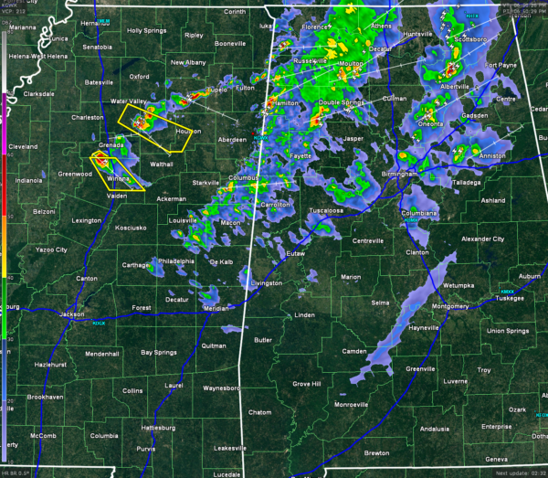
Storms Are Producing Hail But Are Still Below Severe Limits
Within the past 30 minutes (of this post) a few storms developed in Jefferson and Shelby county that produced pea-size hail. This will be the issue with some of the storms tonight, as the second and third lines move closer. We have also seen reports of trees being blown down in Walker county just from the pressure gradient winds. All of the area is under a Wind Advisory until 10PM CDT due to 15-25 MPH sustained winds, with gusts up to 35 MPH possible.
The main action on radar is located north of I-20, with the most active storms approaching Oneonta in Blount county, and another moving into Calhoun county from St. Clair and extreme northern Talladega county. These storms were moving to the northeast at 45 to 50 MPH.
The second line of is mostly light to moderate rain, with some embedded heavier thunderstorms. They are currently stretching from Limestone and Lauderdale counties, to the west of Jasper, Berry in Fayette county, Gordo in Pickens county and down to Cochrane.
There is a third broken line that is making its way across north-central Mississippi. Two of the thunderstorms in this line currently have Severe Thunderstorms on them. The first one is for northern Montgomery and northeastern Carroll counties until 7:45 PM The second one is for southwestern Chickasaw, central Calhoun, and eastern Yalobusha until 7:30 PM. These were currently moving southeast at 40-45 MPH.
Category: Alabama's Weather, Severe Weather


