Series of Wet/Dry Periods This Week
Clouds increased across Alabama overnight with the state covered by clouds this morning including a few sprinkles. Radar did not show a lot of rain in Alabama, and the rain that was showing up was pretty light. Temperatures this morning ranged from near freezing in the northeast corner of Alabama to the lower 50s in the Tuscaloosa area. Fortunately, since the wind stayed up overnight, those rather chilly temperatures across Northeast Alabama did not result in any frost.
For beach goers, look for sunny weather today. Temperatures will be in the lower 70s for most spots on the beach. Scattered showers and storms return to the forecast early next week. You can see the complete Gulf Coast 7 Day Planner here.
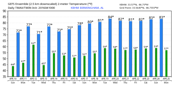
The weak upper short wave trough responsible for producing the sprinkles this morning will move quickly across the Southeast US allowing us to dry out this afternoon with some sunshine returning. Highs should top out around 70 degrees.
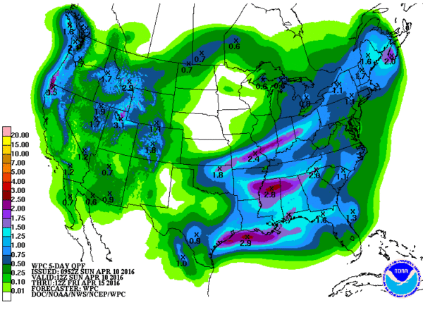
Monday starts out dry, but another short wave trough will advance out of the Texas/Oklahoma Panhandle area on Monday reaching the Carolinas by Tuesday afternoon. Showers and thunderstorms will become possible late in the afternoon, and Monday evening/early Tuesday morning should be rather wet. Rainfall could be relatively heavy with amounts of 1 to 2 inches possible. Highs Monday should be in the 70s.
Tuesday morning the showers and thunderstorms will be ending across Central Alabama as the weather turns dry once again. With a large surface high over to our north and northeast, temperatures will fall back somewhat with highs Tuesday in the upper 60s.
Weak ridging aloft promises a good Wednesday for Central Alabama as we turn our attention to the next trough developing on the eastern slopes of the Rockies. It moves out across the Lower Mississippi River Valley on Thursday turning our weather cloudy once again. This trough will be fairly low latitude, so the greatest potential for showers and thunderstorms will be along the Gulf Coast from Louisiana to the Florida Panhandle, but we could see some showers and a few thunderstorms in our area. There is some potential for severe weather with this system, but the current data does not provide much confidence for that kind of forecast since the overall dynamics for this system do not appear to be that strong. Certainly we’ll want to keep an eye on future model runs to see if that system remains weak.
Friday that system strengthens according to the GFS as it moves out of the Mid-Atlantic States into the Atlantic Ocean. But as it departs a fairly sharp ridge develops over the Mississippi River Valley promising some great weather for next weekend. By Saturday and Sunday we should be once again seeing highs into the 70s with lows in the upper 40s and lower 50s.
A trough over the Upper Mississippi River Valley promises to bring a round of storms to the Southeast US around April 20th. But by April 23rd a strong upper ridge should bring good weather for that weekend. A strong upper low by Monday, April 25th, could produce some active weather for the Central US.
I wanted to say thanks to all the folks who came out to the BJCC yesterday for our Storm Spotter Xtreme. We had a great crowd. Special thanks, too, to Kevin Laws from the National Weather Service for sharing a lot of great information on the overall weather warning process.
James Spann will have the next edition of the Weather Xtreme Video here tomorrow morning. I hope you enjoy the day despite the sprinkles. Stay dry and Godspeed.
-Brian-
Category: Alabama's Weather


