

Severe Thunderstorm Watch for Southwest Alabama
UPDATE AT 704 PM
The NWS in Birmingham has issued an areal flood advisory for Bibb, Greene, Hale, Marengo, Sumter and Tuscaloosa Counties in West Alabama. Widespread 1-2 inch rainfall amounts have fallen across West Alabama with over two inches across parts of Fayette, Lamar and Pickens Counties. Those counties are not included because the heaviest rain has moved out of them.
Be alert is you are out tonight for localized flooding and water standing on roadways.
0.61 inches at the Airport in Birmingham now. I have picked up 0.58 inches here in Vestavia.
ORIGINAL POST
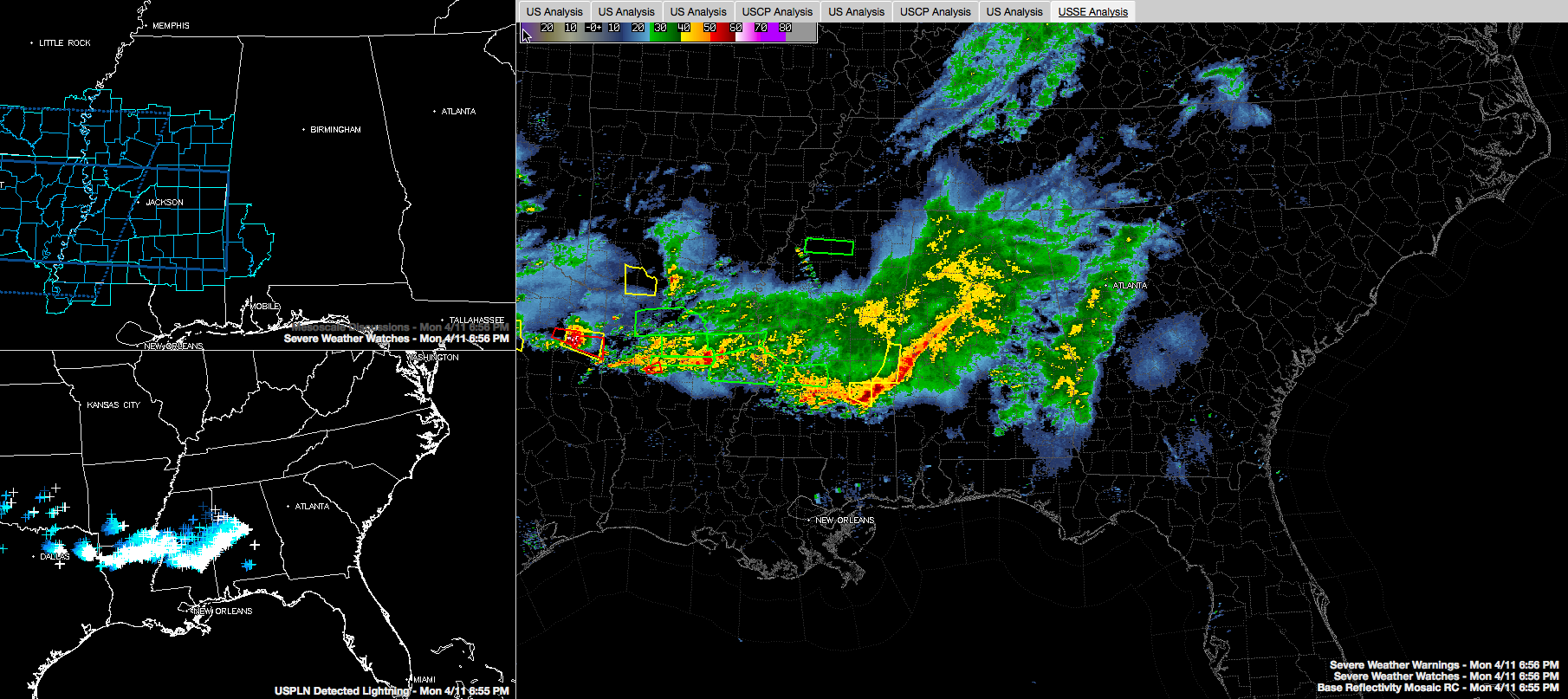
Click image to enlarge.
Strong thunderstorms continue this evening across eastern Mississippi into West Central Alabama. They extend from Jefferson and Shelby Counties southwest through Tuscaloosa, Bibb, Perry, Greene, Hale and Sumter Counties.
The storms have produced damaging winds in eastern Mississippi where the airmass is more unstable. Severe thunderstorm warnings are in effect for Lauderdal and Jasper Counties in Mississippi, but the NWS in Birmingham is choosing to go with significant weather alerts, one step below a warning, for that dangerous storm between York and Livingston. This storm will push into Marengo County and eventually affect Demopolis.
That damaging wind threat will persist into the far southwestern counties like Clarke, Choctaw and Washington. The Storm Prediction Center has issued a severe thunderstorm watch for these counties until midnight.
Choctaw and Washington Counties were just put under a severe thunderstorm warning until 745 p.m.
Severe thunderstorm watches blanket the landscape from the Alabama border across all of Central Mississippi, northern Louisiana, southern Arkansas, northeastern Texas and southern Oklahoma.
Further north, across Greene, Hale, Tuscaloosa and Jefferson Counties, the severe threat is limited as there is not much if any, surface based instability. Our instability is coming from warm air that is being transported in by a low level jet stream at 5,000 feet. Heavy rain and lightning and some gusty winds are the main threat. You can see oall of the lightning in the lower left panel of the graphic.
Category: Alabama's Weather, Severe Weather
About the Author (Author Profile)
Bill Murray is the President of The Weather Factory. He is the site's official weather historian and a weekend forecaster. He also anchors the site's severe weather coverage. Bill Murray is the proud holder of National Weather Association Digital Seal #0001 @wxhistorianSubscribe
If you enjoyed this article, subscribe to receive more just like it.


