Drier Today; Rain Returns Tomorrow
RADAR CHECK: Most of the rain is over South Alabama early this morning… mostly south of U.S. 80…
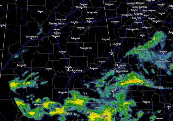
The best chance of showers and storms today will remain over the southern half of the state; North/Central Alabama will be generally dry through tonight, and some sun is possible this afternoon. The high today will be in the 68-72 degree range. The weather will be dry for tonight’s Birmingham Barons home opener at Regions Field.
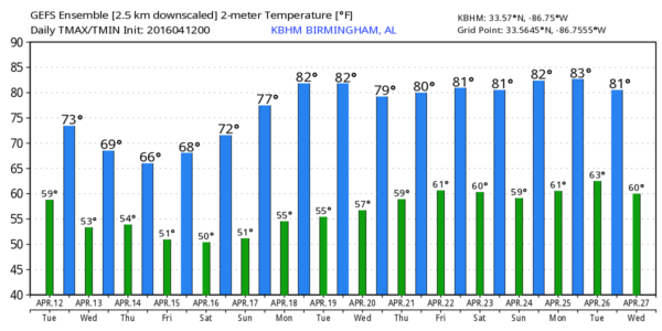
TOMORROW/THURSDAY: The high resolution NAM model is more aggressive with rain for the northern half of the state, and we will adjust the forecast accordingly. The stalled front over far South Alabama should lift northward as a warm front, and it now looks like rain will become likely over North/Central Alabama tomorrow afternoon, tomorrow night, and into at least part of the day Thursday. No severe weather issues, but rain amounts between 1/2 and 1 inch are likely. We will project a high between 65 and 70 degrees both days with very little sun.
FRIDAY: Model madness is making for a lower confidence forecast; the GFS is mostly dry, but the European (ECMWF) model wants to keep showers around. Considering the time of the year and the pattern, we will insert the risk of a few showers in the forecast Friday, and will adjust accordingly as we get closer. Friday’s high will be in the upper 60s.
THE WEEKEND: Dry air takes over, and the weekend will feature splendid weather with sunny mild days and clear nights. We reach the mid 70s Saturday, followed by upper 70s Sunday. Some spots might touch 80 degrees Sunday afternoon.
NEXT WEEK: Warm, dry weather continues Monday and Tuesday… for now it looks like the next chance of showers and storms will come Thursday. See the Weather Xtreme video for maps, graphics, and more details.
WAKE LOW: A mesoscale low pressure center trailed the big rain mass over North Alabama last night, and produced strong winds of 35-45 mph for about 30 minutes or so; this was responsible for some scattered wind damage across the northeast counties of the state. Wake lows can form due to adiabatic warming at the back edge of big rain shields, where evaporative cooling is unable to offset warming due to atmospheric subsidence, or downward motion. They are almost impossible to forecast, and often are associated with a very tight radar gradient on the back edge of a large area of rain.
AT THE BEACH: Mostly cloudy with occasional showers and thunderstorms through Friday on the Gulf Coast from Gulf Shores over to Panama City Beach, but the weekend will be dry with sunny days. Highs mostly in the 70s… See a very detailed Gulf Coast forecast here.
WEATHER BRAINS: Don’t forget you can listen to our weekly 90 minute netcast anytime on the web, or on iTunes. This is the show all about weather featuring many familiar voices, including our meteorologists here at ABC 33/40. Scroll down for the show notes on the new episode we recorded last night.
CONNECT: You can find me on all of the major social networks…
Facebook
Twitter
Google Plus
Instagram
Look for the next Weather Xtreme video here by 4:00 this afternoon… enjoy the day!
Category: Alabama's Weather
About the Author (Author Profile)
James Spann is one of the most recognized and trusted television meteorologists in the industry. He holds the AMS CCM designation and television seals from the AMS and NWA. He is a past winner of the Broadcast Meteorologist of the Year from both professional organizations.Subscribe
If you enjoyed this article, subscribe to receive more just like it.


