

Somewhat Wet Weekend
Cloudy skies were greeting Alabamians this morning as moisture levels have risen and the potential for showers and thunderstorms has gone up. Not only that, we will be dealing with a new tropical system late this weekend which will provide heavy rain to the state of Florida.
This morning a large cluster of thunderstorms was moving across South Alabama and is likely to weaken as it gets into Southwest Georgia. With a significant trough moving through the Great Lakes moisture levels across the Southeast US were increasing substantially with an upper low over southern Texas. This situation will create plenty of clouds today with some peeks at the sun from time to time along with numerous showers and thunderstorms. Highs across Central Alabama should reach the middle 80s and that’s about 8 degree cooler than yesterday.
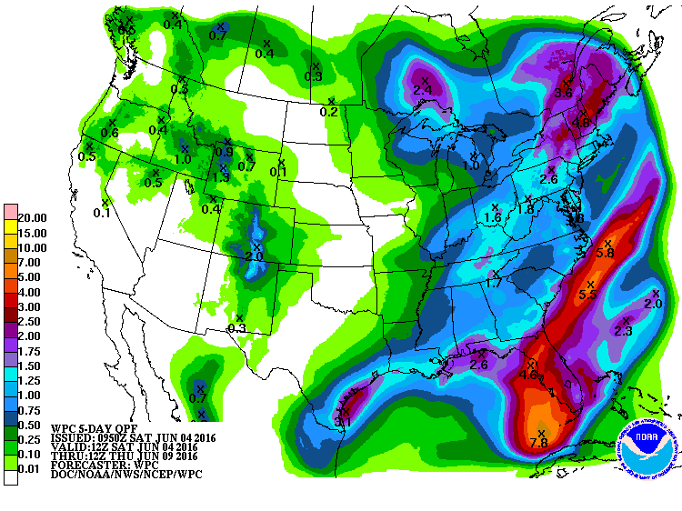
The increased moisture, however, may also lead to the potential for storms today and Sunday to produce some locally heavy rain. While widespread rain is likely to be in the 1 to 1.5 inch range, some of the stronger storms could result in local amounts to 2 inches or slightly higher. We’ve been dry for a good while, at least a week for most folks, so I don’t think we have a significant risk for flash flooding. I know there are lots of outdoor activities going on this weekend, so you may want to carry your rain gear. Remember, don’t become a lightning statistic. When lightning roars, go indoors!
For you beachgoers, you can expect an increase in shower and thunderstorm coverage through the weekend. Not a washout by Gulf Coast standards but most places could end up with about an inch of total precipitation by Monday. Despite the higher rain chances, there will still be plenty of sun at times, and afternoon highs will be 80s. The sea water temperature at Perdido Pass at Orange Beach was running around 85 degrees. See a very detailed beach forecast here.
Sunday is going to be another relatively wet day for much of the Southeast US as the major trough moves slowly across the eastern half of the country. The trough should drag a cold front into the area keeping our chance for showers and storms high once again. Clouds and numerous storms will keep temperatures down once again with highs in the lower 80s.
Sunday, especially late in the day, will see the disorganized area of showers move out of the western Caribbean across the Yucatan Peninsula. As this area of lower pressure moves off the Yucatan Peninsula Sunday evening, it is forecast to develop into an organized tropical system and would likely be named Colin. With a trough moving across the eastern US, this system is not expected to dilly-dally and it will move into the East Central Gulf by Monday afternoon. By early Tuesday morning, it will be moving across the Florida Peninsula making landfall north of Tampa and exiting Florida in the vicinity of Jacksonville. There continue to be some slight model differences between the GFS and the European, but these remain relatively small. The European is still slightly stronger with this system than the GFS is. No matter which one is closest, it means a wet start to next week for much of Florida from Tallahassee to Miami with rainfall amounts of 4 to 6 inches possible. This system is not likely to have a direct impact on the Gulf coast beaches of Alabama and Northwest Florida as it remains on the left side of the expected track which would be the drier side. Fortunately the system is expected to move pretty quickly, so anyone on vacation in the Florida Peninsula should see only a fairly short period of really inclement weather.

The trough along the eastern US becomes the primary feature through much of the week ahead. This pattern will see the tropical system move quickly along the Carolina coast on Tuesday and well out into the Atlantic on Wednesday. For Central and North Alabama, we dry out once again on Monday and stay that way through the work week as the northwesterly flow aloft ushers drier air into the area. Dew points should drop off nicely by midweek with values into the 50s. Temperatures will be fairly seasonal with readings in the 80s.
By Friday and into next weekend, an upper ridge to our west will gradually slide eastward to become the main player in our weather pattern. This means a return of moisture along with summer-like temperatures with the highs by Friday and Saturday back into the lower 90s. Those daily hit and miss showers will probably also return. But, hey, we get a few days off from the heat and humidity.
Looking out into voodoo country, another strong trough is forecast to move into the Great Lakes around Monday, but this trough does not appear to be as formidable as the one just ahead of us. It may help to increase shower chances for Alabama into the first part of week 2, but it definitely is not showing the deepness of the one we’re dealing with right now. And by the end of the period around the 18th of June, a big ridge has once again taken over the weather pattern for the eastern half of the country.
I expect to have the next Weather Xtreme Video posted here by 8 am or so on Sunday morning. You can check back regularly for updates on the Alabama weather scene. Have a great day and Godspeed.
-Brian-

Category: Alabama's Weather
About the Author (Author Profile)
Brian Peters is one of the television meteorologists at ABC3340 in Birmingham and a retired NWS Warning Coordination Meteorologist. He handles the weekend Weather Xtreme Videos and forecast discussion and is the Webmaster for the popular WeatherBrains podcast.Subscribe
If you enjoyed this article, subscribe to receive more just like it.


