Another Wet-ish Day, Cooler Ahead
Much of Alabama waking up to some morning showers and storms, so if you missed the rain yesterday, there is still hope you’ll get some today.
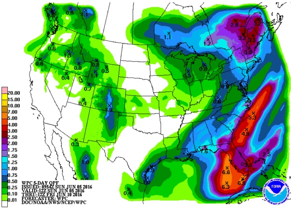
Central Alabama is in a very moist air mass, so it is not surprising to see many areas of Alabama benefitting from early morning showers and thunderstorms. The development of thunderstorms is being aided by a jet streak which is helping to produce lift. So the jet streak will help us see thunderstorms this morning, then we may get a break in the action around the noon hour, before afternoon heating and the approach of a cold front help to develop more thunderstorms this afternoon and evening. Overall most spots have the potential for seeing rainfall in the range from three-quarters of an inch to one and a quarter inches. Clouds and active storms will hold temperatures in the lower 80s even with most places starting out in the 70s.
For beachgoers, you can expect higher shower and thunderstorm coverage today. However, the weather will not be a washout, but much like here, you will be dodging rain at times. Despite the unsettled weather this weekend, there will still be sun at times, and afternoon highs will be 80s. The weather will improve drastically by midweek, as sunshine returns in full supply. The water temperature at Perdido Pass at Orange Beach was 84 degrees. See the complete Gulf Coast 7 Day Planner here.
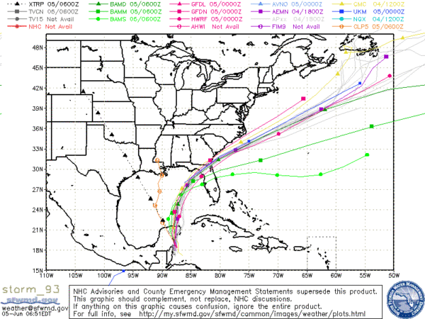
Turning our attention to the tropics, there is still an excellent chance that later today or early Monday we’ll see the area of disturbed weather over the Yucatan Peninsula move into the extreme southern Gulf of Mexico and a tropical system will be born. When it is named, it will be Colin. Models continue to show a rather tight cluster for the future track that takes it across the eastern Gulf into Florida north of Tampa. It is expected to exit near Jacksonville and could grow in strength as it moves over the warm water of the Gulf Stream in the Southwest Atlantic. Current projections keep the center of circulation offshore, but there will be some effects for the coastal Carolinas. The Florida Peninsula is expected to see breezy conditions along with heavy rain on the order of 3 to 6 inches. Fortunately the storm is expected to move briskly keeping the time of inclement weather for folks visiting Florida to a relative minimum.
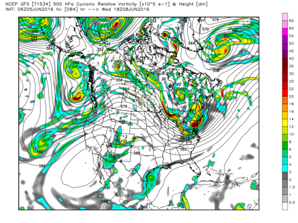
The upper trough which is settling into the eastern US and helping to steer that future tropical system northeastward will bring a few days of cooler and drier weather to the Southeast US. Monday the chances for showers dips back greatly as the front moves from northwest to southeast across the state. By Monday afternoon we should begin to see the dew points fall off slowly as they dip back into the lower 60s. Highs for Monday will still be warm with readings in the middle 80s.
Tuesday and Wednesday we should really feel the effects of the northwesterly flow aloft and the northerly flow at the surface as dew points fall into the 50s. Look for the highs Wednesday to be in the middle 80s with lower humidity making it feel nice.
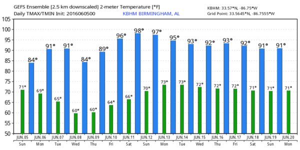
The upper trough gradually works its way eastward Thursday and Friday as the ridge to our west becomes the prevailing feature in our weather pattern. At the surface we’ll see a high pressure area settle across the Southeast US finally reaching a position just off the Southeast US Coast by Friday and Saturday. We do begin warming back up with lower 90s Friday and into the weekend, but we should remain dry to start the weekend. May need to introduce scattered showers into the forecast for Sunday, but I’m not expecting any widespread rain.
Looking out into voodoo country, the prevailing upper air patter will be a ridge over the eastern half of the country. Traveling weather systems can be seen moving along the US-Canadian border as the westerlies remain pretty far north, but typical for this time of year. By the end of the period around June 20th, the pattern is flat with nearly zonal flow across the US indicating a large amount of summer heat for the country.
James Spann will be back with the next edition of the Weather Xtreme Video first thing on Monday morning. You can always check here for updates on the Alabama weather scene plus updates on what is happening in the tropics. Enjoy the day, but stay weather aware and don’t become a lightning statistic. Godspeed.
-Brian-
Category: Alabama's Weather


