Moisture Levels Rising Over The Weekend
CALM MORNING: Temperatures are in the 50s and 60s across Alabama this morning, and the sky is mostly fair. We project a good supply of sunshine today with a high up in the low 90s; scattered storms are possible over far South Alabama, where SPC has defined a “marginal risk” of severe storms in a narrow zone from Mobile to Dothan…
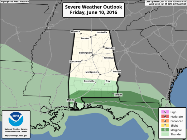
The northern half of the state will remain dry.
THE WEEKEND: We will introduce the risk of isolated showers tomorrow afternoon, but most of the state will be dry with a partly sunny sky and a high in the low 90s. Then, on Sunday, the upper ridge weakens, and we will mention “scattered, mostly afternoon and evening showers and thunderstorms” statewide. Otherwise, expect a mix of sun and clouds Sunday with a high back in the 90-93 degree range.
NEXT WEEK: A moist, unstable airmass will remain in place, and with colder air aloft we will have scattered showers and storms around on a daily basis (which is not uncommon in summer in Alabama). Best chance of showers will come between 2 and 8 p.m., but we can’t rule out a late night or morning shower. The coverage of summer storms is dependent on small, mesoscale features, and it is almost impossible to determine which day will have the highest coverage of showers and storms.
Days next week will feature a mix of sun and clouds, and afternoon highs will be generally in the 88-91 degree range. See the Weather Xtreme video for maps, graphics, and more details.
AT THE BEACH: About 7 to 9 hours of sunshine for the Gulf Coast from Panama City Beach over to Gulf Shores through early next week, with the daily chance of scattered thunderstorms. Highs will be in the 80s on the immediate coast, with low 90s inland. The sea water temperature early this morning at the Dauphin Island Sea Lab is 84 degrees. See a very detailed Gulf Coast forecast here.
TROPICS: The Atlantic basin is quiet, and tropical storm formation is not expected through early next week.
AIR QUALITY ALERT: Ozone is expected to be in the ORANGE (Unhealthy for Sensitive Groups) range, which will trigger an Air Quality Alert for the Birmingham metro. Defer using gas-powered engines. Walk, bike, carpool, or use transit if possible. Link errands into one trip. Conserve energy.
WEATHER BRAINS: Don’t forget you can listen to our weekly 90 minute netcast anytime on the web, or on iTunes. This is the show all about weather featuring many familiar voices, including our meteorologists here at ABC 33/40.
CONNECT: You can find me on all of the major social networks…
Facebook
Twitter
Google Plus
Instagram
Look for the next Weather Xtreme video here by 4:00 this afternoon… enjoy the day!
Category: Alabama's Weather
About the Author (Author Profile)
James Spann is one of the most recognized and trusted television meteorologists in the industry. He holds the AMS CCM designation and television seals from the AMS and NWA. He is a past winner of the Broadcast Meteorologist of the Year from both professional organizations.Subscribe
If you enjoyed this article, subscribe to receive more just like it.


