

Midday Nowcast: Showers And Storms Already, More Expected To Form Today

At this hour, a few showers and thunderstorms are in progress over parts of Central Alabama. Most of the activity is located in the eastern part of the area over southwestern Cleburne, northern Randolph, much of Clay, and extreme southeastern Calhoun counties. These are moving to the north-northeast at 15 MPH. There are a few isolated showers located in the western parts of the area over Fayette, Walker, Tuscaloosa, Dallas, and Autauga counties. These are nearly stationary and are starting to dissipate.
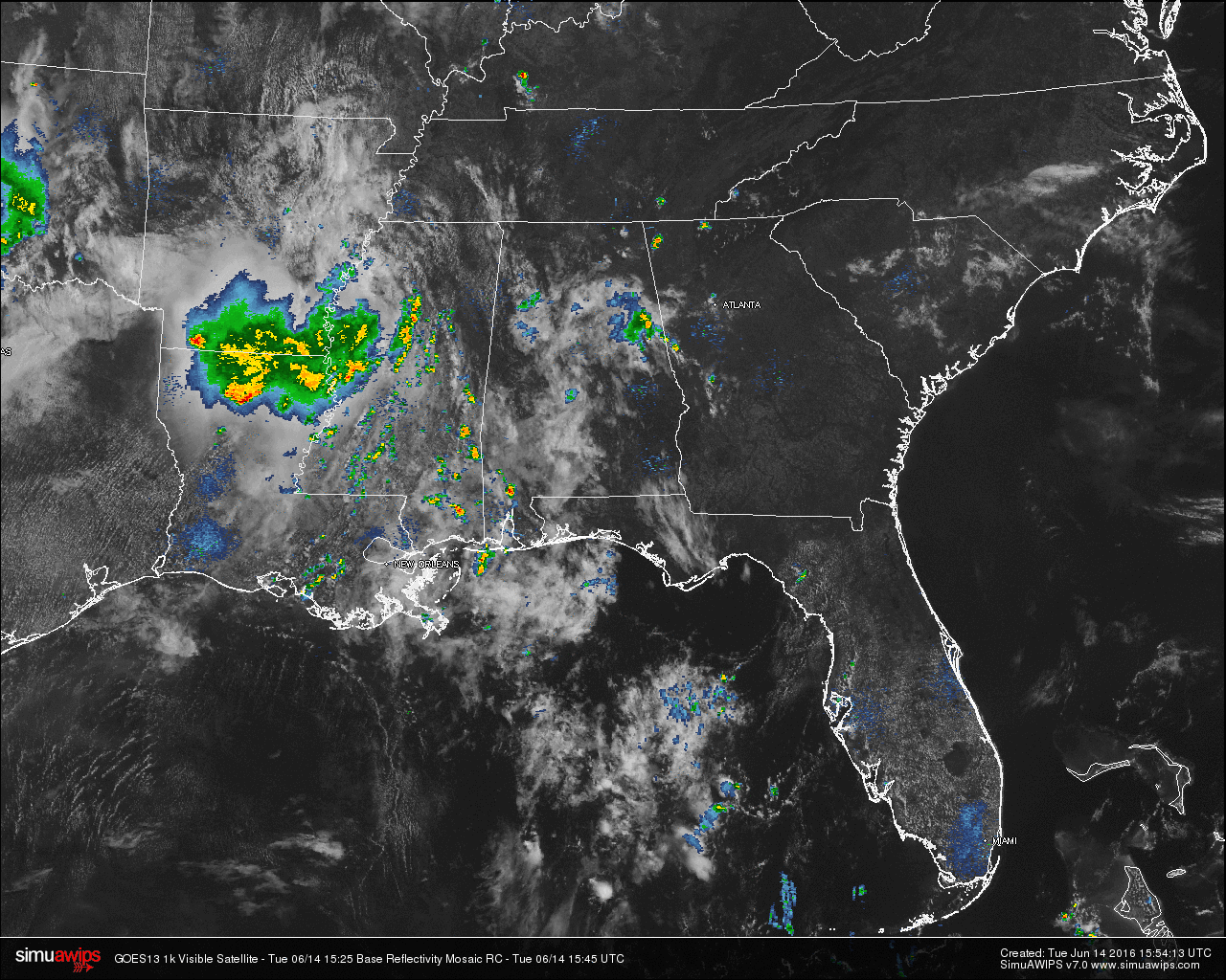
Across the state, its partly cloudy for most areas in Alabama except for the extreme northern and the southeastern parts of the state, where it is mostly clear. Showers and thunderstorms are located in northern Mobile and Baldwin counties, and are moving to the east at 15 MPH. A small shower has popped up near Fort Morgan at the Gulf Coast, with a larger thunderstorm back off to the west just off of Dauphin Island. These are moving eastward as well, and will probably affect Gulf Shores by 12PM-1PM.
TEMPERATURES ACROSS THE AREA
You can definitely tell where rain has fallen already and cooled the air, as those places have temperatures in the 70s currently, while the dry places are well up into the 80s. The warm spot at this hour is Montgomery at 86. Here is a list of readings form around the state:
Birmingham: 76
Tuscaloosa: 77
Anniston: 76
Muscle Shoals: 84
Huntsville: 85
Alexander City: 75
Montgomery: 86
Dothan: 85
Mobile: 82
REST OF TODAY
With high moisture levels, hot temperatures, and instability, scattered showers and thunderstorms are expected to develop later today and this evening. Not everyone will receive rain today, but where a storm develops, gusty winds, heavy downpours, and frequent cloud-to-ground lightning can be expected. Otherwise, a mix of sun and clouds with afternoon highs in the low to mid 90s.
TODAY’S CLIMATOLOGY FOR BIRMINGHAM
The normal high for June 14th in Birmingham is 87F, and the normal low is 65F. The record high for this date, in Birmingham, was set back in 1971 at 98F. The record low of 51F was set back in 1995.
AIR QUALITY
Air quality index for the Birmingham metropolitan area for today is in the Code Green (good) range for ozone and particulate matter.
TOMORROW
It will almost be a carbon copy for Wednesday in Central Alabama, with the upper trough and cold air aloft will be the catalyst to fire off scattered showers and thunderstorms with the heating of the day. Otherwise, a mix of sun and clouds with afternoon highs back in the low to mid 90s.
HEADED TO THE BEACH
About 5 to 7 hours of sunshine along the coast from Gulf Shores to Panama City Beach through Friday with the daily risk of scattered showers and thunderstorms. The weekend will feature sunny weather Saturday and Sunday with only a slight risk of shower. Highs will be in the upper 80s on the immediate coast, with 90s inland. See a very detailed Gulf Coast forecast here.
TROPICS
All is quiet and tropical storm formation is not expected this week across the Atlantic basin.
THIS DAY IN WEATHER HISTORY
On June 14, 1989, over $28 million in damage was caused by high winds associated with thunderstorms in Montgomery County Maryland. Over 62 reports of damaging wind and large hail with this line of thunderstorms that developed ahead of a cold front stretching from the Middle Atlantic Coast Region to the Central Gulf States.
WEATHERBRAINS
This is the show all about weather featuring many familiar voices, including our meteorologists at ABC 33/40. Don’t forget you can listen to our weekly 90 minute netcast anytime on the web, or on iTunes. You can find it here.
Category: Alabama's Weather
About the Author (Author Profile)
Scott Martin is an operational meteorologist, professional graphic artist, musician, husband, and father. Not only is Scott a member of the National Weather Association, but he is also the Central Alabama Chapter of the NWA president. Scott is also the co-founder of Racecast Weather, which provides forecasts for many racing series across the USA. He also supplies forecasts for the BassMaster Elite Series events including the BassMaster Classic.Subscribe
If you enjoyed this article, subscribe to receive more just like it.


