Midday Nowcast: Rain For Some, Clouds For The Rest. Will More Storms Form?
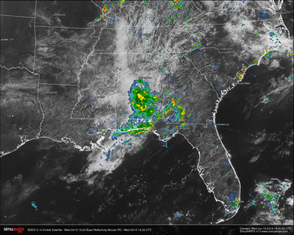
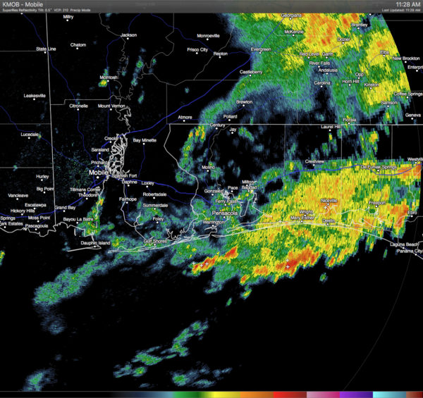
Skies in Central Alabama at this time are mostly cloudy to cloudy at this hour, with showers and thunderstorms over the central counties of the state from extreme southern Jefferson County down south to the Florida/Alabama state line in Escambia, Covington, and Geneva counties.
So far today, rainfall totals at the Birmingham Airport is 0.01 of an inch, the NWS Birmingham office at the Shelby County Airport had 0.02 of an inch, 1.32 inches at Tuscaloosa, 0.33 of an inch at Montgomery, and Alexander City has been dry but that will probably change soon.
Rain and thunderstorms have been affecting the Gulf Coast of Alabama and the western panhandle of Florida as well this morning. Heavy showers and storm are currently stretching to the south and west from Westville and Ebro, Florida back to Gulf Shores and Dauphin Island.
TEMPERATURES ACROSS THE AREA
Most reporting locations are in the 70s currently due to the cloud cover and rainfall in the area. The warm spot at this hour is Mobile at 85. Here is a list of readings form around the state:
Birmingham: 77
Tuscaloosa: 75
Anniston: 77
Muscle Shoals: 81
Huntsville: 83
Alexander City: 78
Montgomery: 74
Dothan: 81
Mobile: 85
REST OF TODAY
With high moisture levels, hot temperatures, and instability, scattered showers and thunderstorms are expected to develop again later today and this evening. Not everyone will receive rain today, but where a storm develops, gusty winds, heavy downpours, and frequent cloud-to-ground lightning can be expected. Otherwise, a mix of sun and clouds with afternoon highs in the mid to upper 80s, with a few communities in the area touching 90 today.
TODAY’S CLIMATOLOGY FOR BIRMINGHAM
The normal high for June 15th in Birmingham is 88F, and the normal low is 65F. The record high for this date, in Birmingham, was set back in 1952 at 98F. The record low of 52F was set back in 1917.
AIR QUALITY
Air quality index for the Birmingham metropolitan area for today is in the Code Green (good) range for ozone and particulate matter.
TOMORROW
Showers and storms will be fewer in number on Thursday, and the temperatures will reach the mid to upper 90s under mostly clear to partly cloudy skies. Any storms that do develop tomorrow will probably pack a punch with the potential for wet microbursts and dangerous cloud-to-ground lightning.
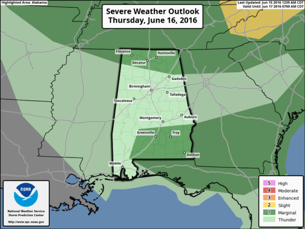
The SPC has defined two separate areas in the state under a “Marginal Risk” for severe storms. The northern part of the state including Florence, Muscle Shoals, Huntsville, and Fort Payne are included in one part, with counties in the southeastern part of the state including Greenville, Troy, and Dothan in the other.
HEADED TO THE BEACH
About 5 to 7 hours of sunshine through Friday on the coast from Panama City Beach over to Gulf Shores, with the daily risk of scattered thunderstorms. The weekend should feature a good supply of sunshine both days with only isolated showers. Highs in the upper 80s on the coast, with 90s inland. See a very detailed Gulf Coast forecast here.
TROPICS
The Atlantic basin is quiet, and tropical storm formation is not expected over the next 48 hours. The guys at NHC are watching lower pressure around the Yucatan peninsula; they suggest a low risk of some type of development around the Bay of Campeche in their Day 5 outlook, but global models aren’t bullish on anything exciting happening there.
THIS DAY IN WEATHER HISTORY
In a 24-hour period on June 15, 1879, McKinney, North Dakota, received a state record of 7.7 inches of rain. Speaking of massive amounts of rainfall, East St. Louis received 16.54 inches in a 24-hour period back in 1957, setting the all-time state record for Illinois.
WEATHERBRAINS
This is the show all about weather featuring many familiar voices, including our meteorologists at ABC 33/40. Don’t forget you can listen to our weekly 90 minute netcast anytime on the web, or on iTunes. You can find it here.
Category: Alabama's Weather


