

Weather Calms Down Today
After several days of very active, sometimes stormy weather, it appears likely that Central Alabama will be in for a break in the action with several days of good weather and somewhat lower humidity.
A weak cold front had moved southward yesterday and last night and was draped across South Alabama. In the upper atmosphere, a big ridge was situated from a center over the Texas Big Bend Country bulging northeastward to the western Great Lakes. This ridge had a maximum height of 597 decameters reported at El Paso, just 30 meters shy of 6000 decameters. The ridge was responsible for heat across a big section of the Southwest US from southern California to Louisiana and northward to Wisconsin. The ridge position together with a trough over the East Coast placed Central Alabama in a northerly flow pattern that was expected to bring us some slightly cooler and dryer air for the weekend and early next week. Showers will still be likely today across South Alabama and the Florida Panhandle. Look for highs today to be in the middle and upper 80s across the northern half of Alabama while South Alabama remains toasty with highs in the lower 90s.
For beachgoers, you can expect to see increasing amounts of sunshine and fewer showers as dry air drops southward, but showers will be plentiful once again today. Highs will be in the upper 80s along the immediate coast but in the lower 90s inland. You can get a very detailed Gulf Coast forecast here.
Organized severe weather is expected to stay across the northern tier of the US for the next several days as the primary storm systems remain well to our north, a pattern we typically see this time of year. Don’t forget that the official start of summer comes on Monday at 5:34 PM CDT as the sun reaches it’s furtherest point before beginning the trek back south.
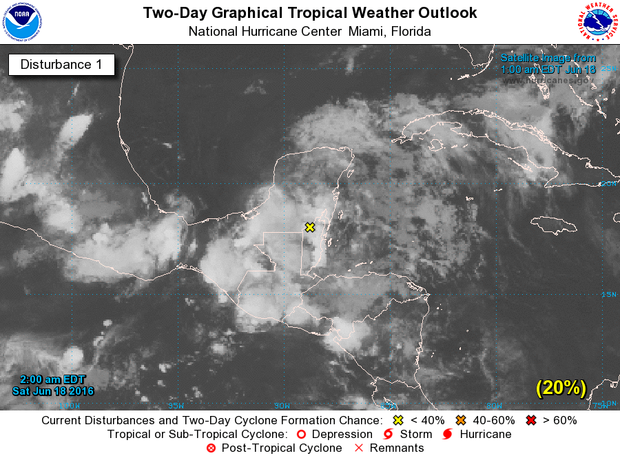
The tropics are quiet with one area of disturbed weather over the Yucatan Peninsula. This area has had trouble getting stronger as it has remained over land. There may be a window for some development as it moves out over the Southwest Gulf of Mexico, but NHC keeps the chance for tropical storm formation at 50 percent.
The GFS keeps our upper air pattern pretty much in check through Monday, so we can expect to see a generally northerly upper flow with slightly drier air in place as dew points fall into upper 50s for Sunday and Monday. Highs will be in the range of 85 to 89 and we should remain shower free.
Tuesday should also be dry but we begin the warm up as highs climb back into the lower 90s, generally 89 to 92. Moisture will also begin to pick up as dew points climb into the lower 60s.
Wednesday and for the rest of the week we’ll need to make mention once again of the potential for isolated showers and thunderstorms during the heat of the day. Highs will be back into the lower 90s and with plenty of low level moisture we can expect the afternoon heat to generate some widely spaced showers each day.
The upper air pattern does not change much until Friday when we see a nice short wave moving out of the northern Plains states. The short wave moves closer by Saturday and may create a better environment for thunderstorms. There are some pretty big differences between the GFS and the ECMWF models out this far, so my confidence in this pattern is not very high since the ECMWF keeps us dry with little impact of a weak surface front. So I’d describe the weather forecast for the latter half of the week as tentative.
Looking into voodoo country, the GFS flattens the ridge across the southern half of the US around the 28th of June, but by July 2nd the pattern looks much like what we are seeing now with a big ridge running from the Southwest US to the western Great Lakes. So it looks like the real heat will stay to our west with a trough over the East Coast to keep the eastern half of the country somewhat cooler.
With all of the weather yesterday afternoon, James Spann did not have time to generate a Weather Xtreme Video. He will be on vacation from now through next weekend, so I will be filling in for him here. That means that we’ll be on a one a day schedule through June 26th. I’ll try to post the discussion and video no later than 8 am each morning. Be sure to check back here for updates on our weather. Godspeed.
-Brian-
Category: Alabama's Weather
About the Author (Author Profile)
Brian Peters is one of the television meteorologists at ABC3340 in Birmingham and a retired NWS Warning Coordination Meteorologist. He handles the weekend Weather Xtreme Videos and forecast discussion and is the Webmaster for the popular WeatherBrains podcast.Subscribe
If you enjoyed this article, subscribe to receive more just like it.


