

Cranking up the Heat
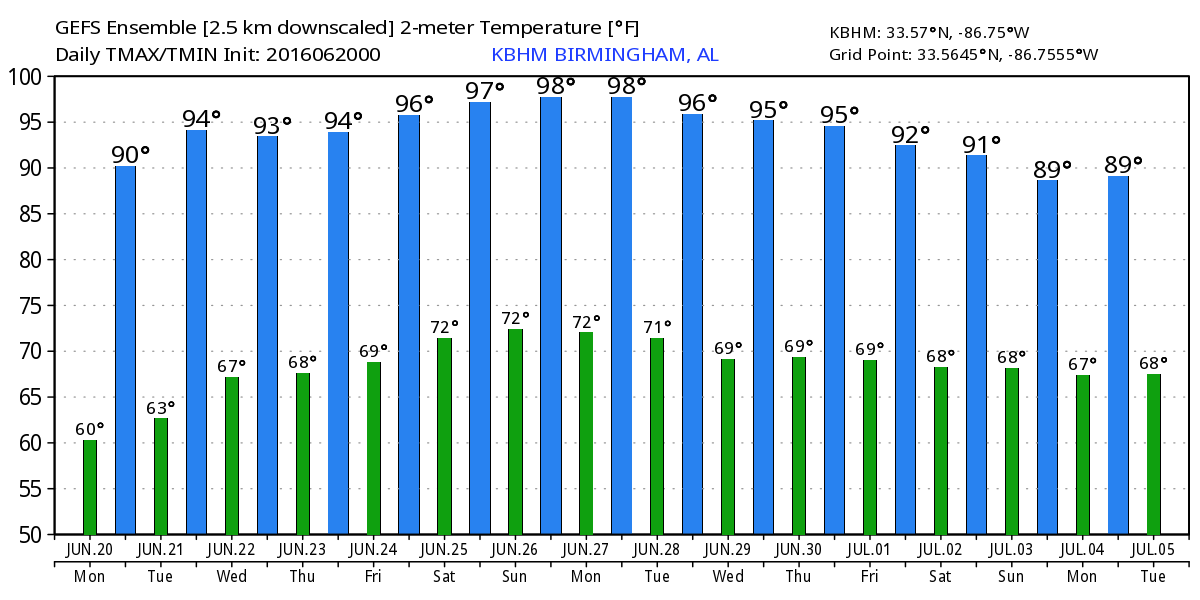
The surface high that was centered over the Carolinas yesterday was settling into Georgia this morning with Alabama experiencing clear skies with morning lows in the 60s. East Central and Northeast Alabama were slightly cooler with morning values in the 50s. Humidity values will remain down today, so even as the afternoon highs climb into the upper 80s with spots nudging that 90-degree mark it will continue to feel fairly nice.
The surface high will continue to migrate into the Northeast Gulf of Mexico as the upper ridge that is producing the exceptional heat over the Southwest US noses its way into the Southeast US.
For beachgoers, the entire coast should be mainly dry with only isolated afternoon and evening storms this week and even into the weekend. Highs will be near 90 with lows in the middle 70s. Water temperatures are climbing through the lower 80s. See a very detailed Gulf Coast forecast here.
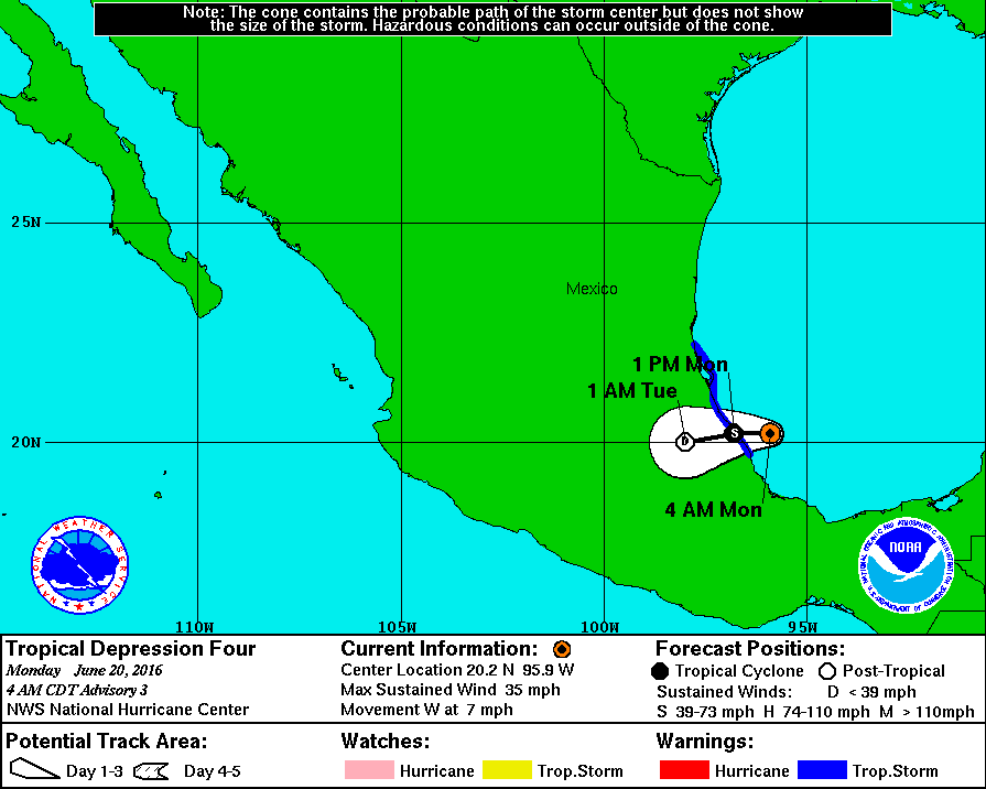
TD 4 is making its way westward and should cross the coast of Mexico later today. The satellite presentation of the storm is more impressive this morning, but it looks like it is going remain a depression as the circulation interacts with the land area.
With the main westerlies well north of Alabama, SPC has a slight risk for severe storms from northern Missouri east-northeastward to Northwest New York for today generally along and ahead of the cold front moving through that area. Day 2 or Tuesday will see the slight risk areas in splotches still along the front stretching all the way from Southwest North Dakota to Iowa to eastern Kentucky and Virginia. Day 3, Wednesday, the risk for severe storms has been bumped up to enhanced in the area from eastern Iowa to western Ohio. The main risk for severe weather comes from hail and damaging wind.
Beginning Tuesday, that big upper ridge will nose into the Southeast US to become the main feature for our weather pattern until Saturday. Dew points will climb into the 60s Tuesday and will likely remain there until Friday with the potential for readings to climb into the 70s by Saturday and Sunday. Beginning Friday and extending into next weekend, we will include the potential for isolated afternoon thunderstorms, but most people will remain dry. Highs will be climbing into the middle 90s and heat indices may once again approach those unhealthful levels from 105 to 110.
The GFS is holding the promise of some big changes to this pattern come Sunday and Monday as a very strong upper closed low move into the western Great Lakes area and begins to carve out a substantial trough over the eastern third of the US. This will end the domination of that upper ridge for the Southeast US as it is pushed back into the Southwest US. If this pattern verifies, we’ll see our best chance for rain in the next 7 to 10 days coming next Sunday and Monday. It would also lower our afternoon highs into the upper 80s with the potential for another shot of drier air for us to experience as we enter July.
Voodoo country has got a big surprise for us. The pattern shift the GFS is forecasting with the eastern US trough appears to stay with us as a broad upper trough. But as we get to the 4th of July, the GFS seems to have gone way out on a limb with a 570 decameter closed low over southern Arkansas. Should this pattern verify, we’ll need to consider building an ark! But it’s my guess that this rather dramatic feature is likely to be gone in the next model run. The idea of troughiness in the eastern US is appealing to me since it would keep us out of any extreme heat.
Remember, James Spann is taking a much deserved week off, so we are working a one-a-day schedule for the Weather Xtreme Videos. I expect to have the next one posted here by 8 am or so on Tuesday morning. Enjoy the slightly drier air while you can. Godspeed.
-Brian-
PS At 7:00 am the National Hurricane Center upgraded TD 4 to Tropical Storm Danielle.
Category: Alabama's Weather
About the Author (Author Profile)
Brian Peters is one of the television meteorologists at ABC3340 in Birmingham and a retired NWS Warning Coordination Meteorologist. He handles the weekend Weather Xtreme Videos and forecast discussion and is the Webmaster for the popular WeatherBrains podcast.Subscribe
If you enjoyed this article, subscribe to receive more just like it.


