

Summer Heat into the Weekend
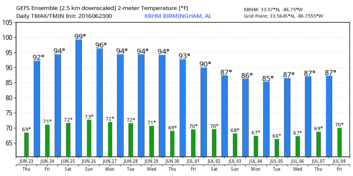
Once again this morning Central Alabama finds itself coming under a large upper ridge that will keep it hot through the weekend. There were a few clouds in the morning sky, but we’ll still see plenty of sunshine today to warm the air into the lower and middle 90s.

The rest of this week and into the weekend promises to be beautiful along the beaches of Alabama and Northwest Florida. It will be seasonably hot with highs near 90 and lows in the middle 70s. Rain chances will pick up by Monday afternoon and will be fairly high Monday afternoon through Wednesday. Water temperatures remained warm with 83 degrees reported at the Dauphin Island Sea Lab.
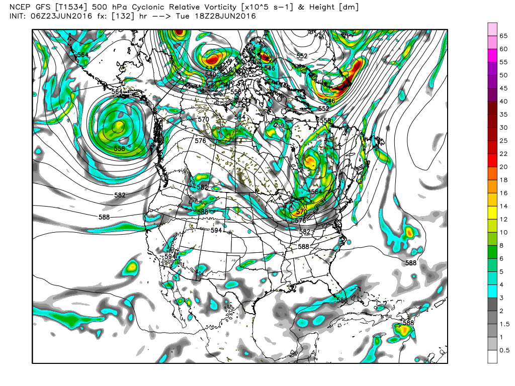
The Storm Prediction Center (SPC) has an enhanced risk for severe storms over West Virginia, southern Ohio, and northern Kentucky today as the system that brought the severe storms to northern Illinois and Indiana progresses eastward. Day Two (Friday) shows a slight risk along the eastern Carolinas and across northern North Dakota. Day Three (Saturday) will see the best chances for organized severe weather across Wisconsin and Minnesota with a marginal risk extending southwest into the Texas Panhandle.
The tropics remain quiet. A large area of cloudiness was noted over the western Caribbean and the Yucatan Peninsula, but there were no signs of any development in that area.
That upper ridge will remain the primary weather feature in the weather pattern for Central Alabama through Sunday. A strong upper low moving across the southern section of Canada will begin to beat that ridge back to the west on Monday as the overall upper air pattern makes a significant change. This means that we stay quite warm into the weekend with highs in the middle 90s and some spots pushing the upper 90s. Heat index values could push that 105 mark, so a heat advisory might be required.
By Tuesday, a trough has begun digging into the eastern US which will help to push a front into the Tennessee River Valley. So Monday and into Tuesday we should see better chances for rain although it will continue to be the showery variety so not everyone may get wet. Temperatures will fall back too as a result of the clouds and the presence of more showers. Look for highs to top out in the lower 90s, basically 90 to 92.
The upper air pattern keeps that trough along the East Coast of the US, so we’ll be under a northwesterly flow. The GFS is once again hinting at the potential for the development of an MCS or two in that flow. This is the development of a large cluster of thunderstorms over the Plains states that will make its way southeastward and could affect parts of the Southeast US. There is no skill this far out to be specific on exactly when and where these develop. This requires keeping a watchful eye for this type of thing to happen with adjustments to forecasts sometimes at the last minute.
Looking out into voodoo country, tropical weather enthusiasts will probably like what the GFS is cooking up now. The GFS maintains a trough over the eastern half of the US as we enter July. That means we should stay warm but keep out of any extreme heat. From July 4th through July 6th the GFS picks up on what could be another tropical system in the Gulf of Mexico that takes aim for Louisiana. We’ll watch this feature in future runs, IF its there.
I expect to have the next Weather Xtreme Video posted here by 7 to 7:30 on Friday morning. I hope you enjoy your day. Godspeed.
-Brian-
Category: Alabama's Weather
About the Author (Author Profile)
Brian Peters is one of the television meteorologists at ABC3340 in Birmingham and a retired NWS Warning Coordination Meteorologist. He handles the weekend Weather Xtreme Videos and forecast discussion and is the Webmaster for the popular WeatherBrains podcast.Subscribe
If you enjoyed this article, subscribe to receive more just like it.


