Heat Continues
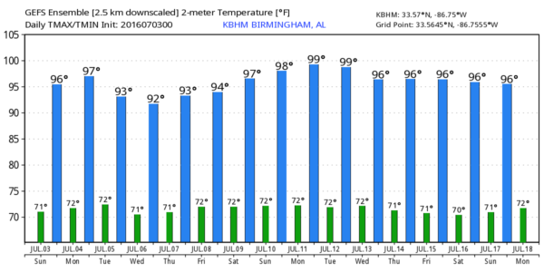
We’re not looking for much relief from the heat for a couple of days with a surface high pressure system over the eastern third of the Nation, so highs will be in the middle and upper 90s today and Monday. Only a few spots will see any showers or thunderstorms driven by the afternoon heat. The heat index values are expected to be in the 100 to 105 range today and Monday, just below heat advisory criteria.
If your plans include the beach, gorgeous weather is expected along the Northern Gulf Coast this weekend and for much of the week ahead. You can expect plenty of sunshine each day with only a small risk of a passing shower or storm, fairly typical for summer at the beach. Highs will be in the upper 80s to lower 90s on the immediate coast with mid 90s inland. The sea water temperature at Perdido Pass at Orange Beach was 88 degrees.
Severe weather today will be focused along a boundary from eastern Oklahoma to eastern Kentucky. Monday, Day 2, the risk shifts to Kentucky and West Virginia with a second area mainly in the Texas Panhandle. Day 3 the focus for severe storms shifts well north of us into Wisconsin.
Tropics are quiet in the Atlantic Basin, but this morning we have Blas and Agatha in the Eastern Pacific. Neither of these is a threat to land. And on the other side of the world, we have Tropical Storm Nepartak passing southwest of Guam.
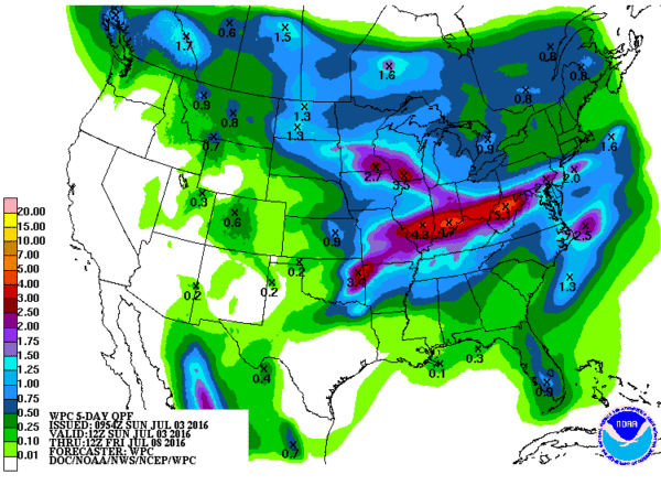
A weak disturbance in the 500 millibar flow will come across the Tennessee Valley on Tuesday and Wednesday. This will bring us our best chance of storms for the next seven days. Even then, not everyone will see a shower and get wet. Rainfall amounts over the next five days will be in the range of one half to three-quarters of an inch with higher amounts further north into Tennessee closer to the boundary. We should see just a little relief from the heat thanks to the presence of more clouds as well as more showers.
For the end of the week, the upper air pattern returns to ridging once again across the eastern half of the country. This ridging pattern should hold through next weekend, so I’m expecting our weather to remain hot with highs in the middle 90s and only isolated thunderstorms in spots to provide any relief from the heat.
Looking into voodoo country, the upper ridge is forecast to maintain itself in place across the eastern half of the country through July 13th. From the 13th to the 18th, the GFS is promising to flip the pattern with a trough in the East and the ridge along the eastern slopes of the Rockies. This would bring about a period of reduced heat for much of Alabama with a northwesterly flow with the additional benefit of lower humidity.
Thanks for tuning into the blog. I’m filling in for Meaghan Thomas this evening on ABC 3340 News at 5 and 10 pm, so you can catch the latest forecast then. Don’t forget to make plans for Freedom Fest at the Hoover Met on July 4th. I will be there along with other ABC 3340 on air folks and there will be a great show with fabulous music and a spectacular fireworks display – and it is all FREE! Hope to see you there. Godspeed.
-Brian-
Category: Alabama's Weather


