Strong Storms Push Southwest
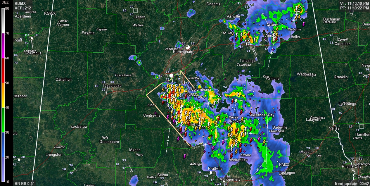
Strong storms continue tonight across Central Alabama.
Storms are most intense along I-65 from Alabaster to Calera to Montevallo to Jemison to Thorsby.
The storms are slowly weakening but will continue for a couple of more hours.
Look for gusty winds, very heavy rains and deadly lightning.
…SIGNIFICANT WEATHER ADVISORY FOR CHILTON…SOUTHWESTERN SHELBY…
EASTERN BIBB AND WEST CENTRAL COOSA COUNTIES UNTIL 1130 PM CDT…
AT 1102 PM CDT…DOPPLER RADAR WAS TRACKING STRONG THUNDERSTORMS
ALONG A LINE EXTENDING FROM 6 MILES SOUTHWEST OF HELENA TO NEAR
CLANTON. MOVEMENT WAS SOUTH SOUTHWEST AT 20 MPH.
WINDS IN EXCESS OF 40 MPH WILL BE POSSIBLE WITH THESE STORMS.
LOCATIONS IMPACTED INCLUDE…
HOOVER…ALABASTER…PELHAM…HELENA…CALERA…CLANTON…
MONTEVALLO…JEMISON…THORSBY…WEST BLOCTON…WILTON…
UNIVERSITY OF MONTEVALLO…CHILTON COUNTY MOTOR SPORTS PARK…
BRIERFIELD IRONWORKS PARK…HIGGINS FERRY PARK…POOLES CROSSROADS…
ASHBY…MITCHELL LAKE…LAY LAKE DAM AND MAYLENE.
Category: Uncategorized
About the Author (Author Profile)
Bill Murray is the President of The Weather Factory. He is the site's official weather historian and a weekend forecaster. He also anchors the site's severe weather coverage. Bill Murray is the proud holder of National Weather Association Digital Seal #0001 @wxhistorianSubscribe
If you enjoyed this article, subscribe to receive more just like it.


