Chapter 2 – Ridge, Ridge, Ridge!
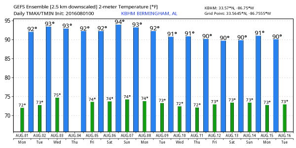
Once again this morning, the Alabama sky features some clouds left over from the convection that occurred yesterday afternoon. Warm and muggy conditions greet people this morning with the morning lows generally in the lower and middle 70s. The surface high pressure over the Southeast US sticks around again today, so I expect to see scattered thunderstorms forming once again in the heat of the afternoon. The HRRR model suggests the storms will be mainly to the east and south of the Interstate 59 corridor. Highs will again top out in the lower and middle 90s.
Standard summer weather will persist for the beaches of the Northern Gulf Coast this week. There will be more sun than clouds, but there will be a few passing storms from time to time. Highs will be in 87 to 90 degree range on the beaches while just inland you can expect low to mid 90s. There may be some rip current issues, so please pay attention to the flags posted along the beaches. See a very detailed Gulf Coast forecast here.
With the primary storm track pushed pretty far north, SPC has a slight risk area covering western Minnesota, eastern portions of the Dakotas, and a chunk of Northwest Iowa for Day 1. Tuesday there are no slight risk areas, but there are two marginal risk areas centered on parts of Wisconsin and Montana. Day 3 has a slight risk primarily over North Dakota.
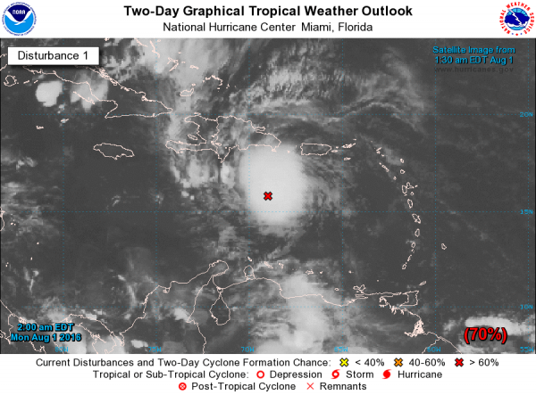
The tropical Atlantic went from two areas to one, but that one appears likely to become the next storm for the 2016 season. It showed some good signs of organization overnight as it continued to move briskly across the Caribbean. The spaghetti tracks for the hurricane models remain fairly closely clustered on a westerly track into the Yucatan and then the coast of Mexico. If this storm is named, it will be Earl.
Meanwhile, the tropical Eastern North Pacific was fairly active with one area of disturbed weather along with Tropical Storm Howard. Neither of these was a threat to any land area.
For the week ahead, the prevailing feature in the upper air pattern affecting the Southeast US will be the ridge. The ridge builds into the Central US over the first part of the week, and then remains fairly well anchored stretching across the southern tier of the US. The traveling weather systems stay primarily in Canada, but as this parade of disturbances occurs they are gradually beating down the strength of the ridge somewhat. No real air mass change for us since the ridge holds across the Southeast US. But the GFS has a little challenge for forecasters for the latter portion of the week as we see a small disturbance at 500 millibars that moves across the Gulf Coast from Thursday through Monday. This easterly wave, while weak, may be just enough to improve rain chances for late this coming week and into the weekend. GFS MOS numbers go up some for Thursday and Friday for Birmingham and Tuscaloosa when the disturbance would have the biggest impact on our weather. So we’ll need to keep a watchful eye on this feature.
So for the week ahead, it looks like the weather remains monotonous with daily chances for showers and thunderstorms. It stays warm with highs mainly in the middle 90s but we may see some upper 90s during the middle of the week. The good news, IF that easterly wave occurs, is that it would produce better rain chances and more clouds, so we could see daily highs held down into the lower 90s despite the presence of the upper ridge.
The long range maps show the GFS to be very bullish on the upper ridge once again as it builds into the Central US around the 11th of August. But the GFS indicates the development of a fairly deep trough over the eastern third of the country around the 15th of August. This pattern is suggestive of a from making it into the Southeast US with the potential of an air mass change. That means cooler and drier air! And we’re getting about to that time when we often see an early Fall front that holds the promise of cooler weather for the Fall. We’ll see.
We remain on a one-a-day schedule through Wednesday. Thanks for the comments on the blog video from yesterday. I promise no more singing! Have a great day and Godspeed.
-Brian-
Category: Uncategorized


