AM Fog with PM Showers
After the round of storms that moved through nearly all of Alabama yesterday, widespread fog developed in the early morning hours. Many locations were reporting visibility reduced to 1 mile or less, so allow a little extra time to reach your destination this morning. The fog should burn off by 9 to 10 am. Then we should see some sunshine before showers start developing in the heat of the afternoon. We have the large cluster of storms in Missouri this morning, and the boundary from that cluster could have an impact on North Alabama weather later this afternoon. The HRRR model is focusing storms on Central Alabama later this afternoon but keeping them scattered with less coverage than we saw yesterday. Highs will reach the middle 90s.
The NWS in Birmingham has posted a heat advisory for later today from 11 am to 9 pm. The heat advisory covers the western and southern sections of Central Alabama generally west and south of a line from Warrior to Alexander City. Dew points were running in the lower 70s this morning and expected to rise slightly this afternoon with values in the middle 70s.
For beachgoers, scattered showers and storms will be the rule along the Gulf Coast through the weekend. The chance of rain on any given day will be about 40 percent. Highs will be around 90 while lows will be in the upper 70s. Water temperatures are hovering just below 90 degrees which is about as warm as it gets in the Gulf. Your complete beach forecast is available here.
SPC has an enhanced risk of severe storms over portions of the Dakotas for Day 1. For Day 2, the main risk for severe storms slides east into the western Great Lakes area, primarily northern Wisconsin. For Day 3, there are no risk areas, even marginal!
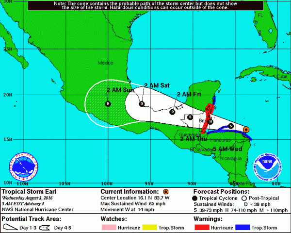
The tropical Atlantic is focused on Tropical Storm Earl. Earl was finally named yesterday, and Earl went through an eye replacement overnight with the new center forming a little south of the previous position. Earl continued to chug westward at 14 mph and may reach hurricane intensity before going ashore in Belize. The track forecast does bring the storm over the extreme southern edge of the Bay of Campeche late Friday and early Saturday. It could restrengthen into a tropical storm for a short period before entering Mexico.
The prevailing upper air feature for us will still be the upper ridge, but the GFS is not quite as bullish on how that ridge will affect the Southeast US. By that I mean the GFS is maintaining a slight weakness on the eastern side of the ridge which ebbs and flows a bit. This means that the forecast will need to maintain chances for showers and thunderstorms for the foreseeable future, but it will be subtle features that may allow forecasts to be a little more specific on where and how much showers will occur over the first 24 to 48 hours of a forecast.
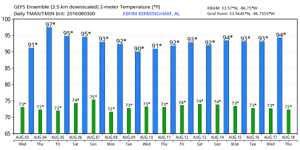
With the ridge being maintained, you can expect highs to be in the lower and middle 90s for the next week or so. Highs will vary a little from day to day depending on just how much cloudiness sticks a round and just how early showers can get rolling. Morning lows should be pretty consistent with values in the lower and middle 70s.
The GFS has settled down a little with less change in the pattern. It keeps the idea of a fairly strong short wave coming across the Central US around the 13th of August. This still looks like a pattern that could bring that first cold front into the Southeast US. That first front serves to remind us that Fall is on the way. And the GFS remained consistent on bringing the heat back around the 17th/18th of August, too.
James Spann is forecast to be back from his vacation on Thursday, so unless he runs screaming down I-65 he should have the next Weather Xtreme Video posted here around 7 am or so tomorrow. I hope that you have a great day and Godspeed.
-Brian-
Category: Uncategorized


