

Unsettled Weather Ahead
Alabama is starting the day out with a mix of sun and clouds as the satellite image showed clouds still leftover from the convection that occurred yesterday. Fog was the most widespread across the Tennessee River Valley and less noticeable across Central and South Alabama. The surface map from the Weather Prediction Center folks showed a front lying across Central Alabama this morning, but that front was extremely hard to locate. That feature along with the upper air weak low in the Northeast Gulf and afternoon heating will combine to create rather unsettled weather across the Southeast US for the foreseeable future. With more clouds and showers/storms becoming more numerous, we should see high temperatures held down so that highs today will be primarily in the lower 90s. Spots that might see sunshine last a little longer, or if showers are a little slower to develop, we could see some highs reach the middle 90s.
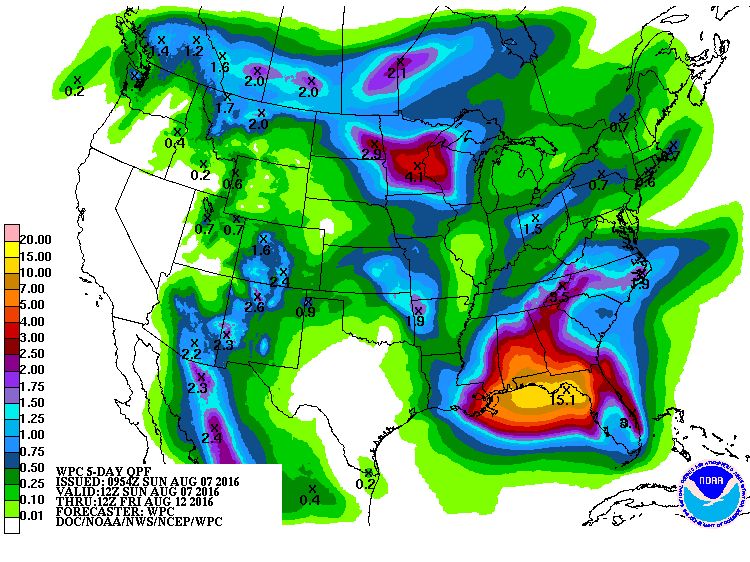
The precipitable water (PWAT) value from the sounding at the Shelby County Airport last night came in at 2.16 inches. This is very high, so stronger storms could produce some torrential downpours with the potential for us to see isolated flash flooding. Just like our lack of skill with where storms will develop there is little skill on being very specific about the locations where flash flooding might occur. And PWAT values are forecast to remain high for the week ahead. So keeping rain gear handy would probably be a good idea.
Beachgoers will also see unsettled weather this week along the Northern Gulf Coast. Starting today, the amount of sun goes down to about 4 to 6 hours daily through much of next week. Thunderstorms will become likely due to the area of unsettled weather in the Gulf and high temperatures should be in the 80s. While there will be better than average chances for rain this week, there will still be periods of sun. Rip currents could be an issue, so make sure you pay attention to the flags posted along the beaches. The sea water temperature at Perdido Pass at Orange Beach was a very warm 88 degrees. See the complete Gulf Coast 7 Day Planner here.
SPC has a very small area of slight risk identified in Montana with a marginal risk area southward into Texas/Oklahoma Panhandle area. Day 2 shows only a marginal risk area in the North Central US. Day 3 features a slight risk in North and South Dakota.
Tropical Atlantic is somewhat quiet with two areas of disturbed weather until scrutiny. One is associated with the upper low in the Northeast Gulf and the other area is approaching the Bahamas. Neither of these areas is expected to develop much in the next few days.
The upper low in the Northeast Gulf is going to keep the weather across much of the Southeast US unsettled for the week ahead. The GFS meanders the low along the Gulf Coast for the next 5 to 7 days. I took a quick look at the ECMWF, and it does much the same but by later in the week takes it further west and a little further south than the GFS. So the bottom line is that we are going to see a rather wet period ahead. Most days will start dry with showers and thunderstorms forming in the late morning or early afternoon. Supported and strengthen by the afternoon heating, some of these storms will continue past sunset with most of them dissipating in the 10 pm to midnight time frame. The only exception to this will come in and close to the lowest pressure aloft. Since precipitable water values remain high and this weakness in the flow is forecast to stay in the neighborhood for the week ahead, the probability of rain will remain high with thunderstorms likely just about every day this week starting today.
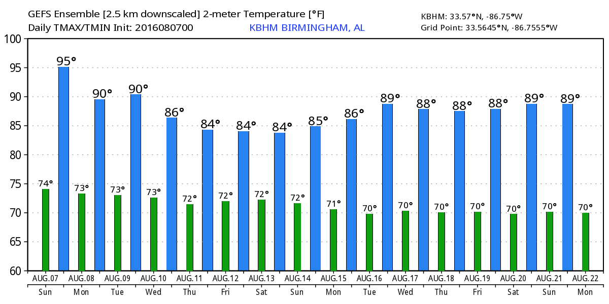
Temperatures will be held down by the clouds and the presence of numerous storms. I expect today to be the warmest day with highs in the lower 90s. For the rest of the week all the way to next weekend, highs will be held mainly to the upper 80s. Morning lows will not change much with values in the lower and middle 70s each day.
But the heat is not over by any stretch of the imagination. The upper ridge builds in strong again around the 16th of August. It maintains itself through the 18th and 19th, but the GFS is still hanging onto the idea that we’ll see a weak front with the promise of some cooler and drier air around the 22nd August. This idea has been consistent on the GFS for several days now, but the inconsistency has been just when the strong trough and surface front occur.
I had a great time visiting with folks in Gadsden yesterday at the Kids Town Alive at the Mary G. Hardin Center for Cultural Arts. I sure appreciate the invitation and especially the cookie with my name on it!! James Spann is expected to have the next Weather Xtreme Video posted her by 7 am or so on Monday morning. Check back often for updates on our changing weather. Have a great day, and Godspeed.
-Brian-
Category: Alabama's Weather
About the Author (Author Profile)
Brian Peters is one of the television meteorologists at ABC3340 in Birmingham and a retired NWS Warning Coordination Meteorologist. He handles the weekend Weather Xtreme Videos and forecast discussion and is the Webmaster for the popular WeatherBrains podcast.Subscribe
If you enjoyed this article, subscribe to receive more just like it.


