Midday Nowcast: Numerous Showers & Storms Out There
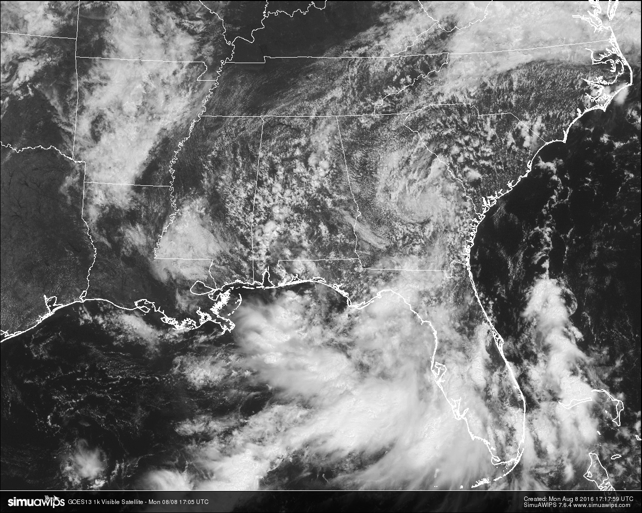
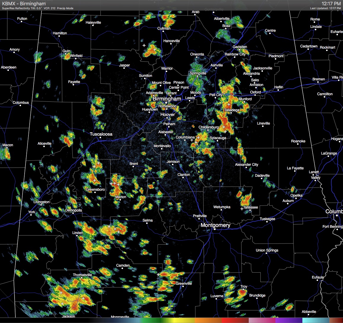
At this hour on the radar, it is actually easier to tell you where scattered showers and thunderstorms are not occurring than it is to tell where they are. Just about every county in the Central Alabama area has an active shower or thunderstorm at this moment. The only places counties not getting rain right now are the ones in the northwestern corner of the state, and the extreme eastern counties. All of these are almost stationary, but are showing a slow movement to the southwest. As with the radar being pretty active with shower and thunderstorm activity, the latest satellite image for Alabama agrees and is showing more clouds than sun for the state.
TEMPERATURES AT THIS HOUR: With a mix of sun and clouds, along with the shower activity, temperatures are being held back in some spots. Here is a list of temperature observations from across the area:
Birmingham 87
Tuscaloosa 88
Gadsden 82
Anniston 85
Cullman 84
Hamilton 87
Clanton 88
Alexander City 81
Montgomery 90
WHAT TO EXPECT FOR TODAY: With the broad surface low nearby over the Gulf Coast region, combined with colder air aloft and a more unstable atmosphere, scattered showers and thunderstorms will be likely throughout the remainder of the day. Skies will be partly to mostly cloudy otherwise, and highs will be at or just over 90º. With precipitable water values at or over 2 inches for the most part, rainfall could be heavy at times, and localized flooding is possible with heavier storms. Severe weather is not expected, but winds could be gusty and cloud-to-ground lightning could be frequent. Rain chances will start to go down during the evening, but the risk for a shower or storm is still there overnight. Lows will be in the 70s.
CODE YELLOW AIR QUALITY: The Air Quality Index for the Birmingham Metropolitan Area will be in the “Code Yellow” for particulate matter 2.5 for today. Unusually sensitive people should consider limiting prolonged outdoor exertion.
TODAY’S CLIMATOLOGY FOR BIRMINGHAM: The normal high for August 8th is 91, while the normal low is 70. The record high for today was set back in 1935 at 104. The record low was set back in 1990 at 60.
TUESDAY: Pretty much the same setup for tomorrow… Partly cloudy with showers and thunderstorms likely throughout the day, but the highest coverage will come during the afternoon and early evening hours. Afternoon highs should be held back into the upper 80s for the most part. Hopefully with the rainfall we receive this week that we can clear some areas out of drought conditions.
HEADED TO THE BEACH: A stormy week at the beach is always better than nice weather while at work, that is what I like to think. Showers and thunderstorms are likely throughout the week and weekend ahead. Some storms could pack a punch with gusty winds, torrential downpours, and frequent cloud-to-ground lightning. Flash flooding could be an issue at points throughout the week. Highs will be in the mid to upper 80s, with overnight lows in the mid to upper 70s. Seas will be rough with the storms, so expect the risk for rip currents to be moderate to high. See a very detailed Gulf Coast forecast here.
THE TROPICS: There is an unorganized area of showers this is located a few hundred miles northeast of the Bahamas that is associated with a mid-level low. No surface circulation has been detected, and the NHC is giving this disturbance little to no chance of forming into any tropical cyclone. Former Hurricane Earl has crossed Mexico and has reformed into Tropical Storm Javier in the Pacific Ocean. Javier is expected to eventually weaken into a depression over the next few days, as it moves up the east side of Baja California.
ON THIS DAY IN 1989: Early evening thunderstorms around Las Vegas NV produced wind gusts to 116 mph. The high winds damaged or destroyed about eighty- two aircraft at Henderson Sky Harbor Airport and McCarran International Airport, causing fourteen million dollars damage.
THE BLOG IS ON TWITTER: Be sure to follow the Alabama Wx Weather Blog on Twitter. Just click here to start following our feed.
WEATHERBRAINS: This week, we will be previewing the upcoming National Weather Association Annual Meeting with the President, Executive Director, Social Media Chair and Program Chair. This is the show all about weather featuring many familiar voices, including our meteorologists at ABC 33/40. You can listen anytime on the web, or on iTunes. You can find it here.
ADVERTISE WITH US: Deliver your message to a highly engaged audience by advertising on the AlabamaWX.com website. The site enjoyed 10.2 MILLION pageviews in the past 12 months. Don’t miss out! We can customize a creative, flexible and affordable package that will suit your organization’s needs. Contact Bill Murray at (205) 687-0782.
Category: Alabama's Weather
About the Author (Author Profile)
Scott Martin is an operational meteorologist, professional graphic artist, musician, husband, and father. Not only is Scott a member of the National Weather Association, but he is also the Central Alabama Chapter of the NWA president. Scott is also the co-founder of Racecast Weather, which provides forecasts for many racing series across the USA. He also supplies forecasts for the BassMaster Elite Series events including the BassMaster Classic.Subscribe
If you enjoyed this article, subscribe to receive more just like it.


