Numerous Showers/Storms Again Today
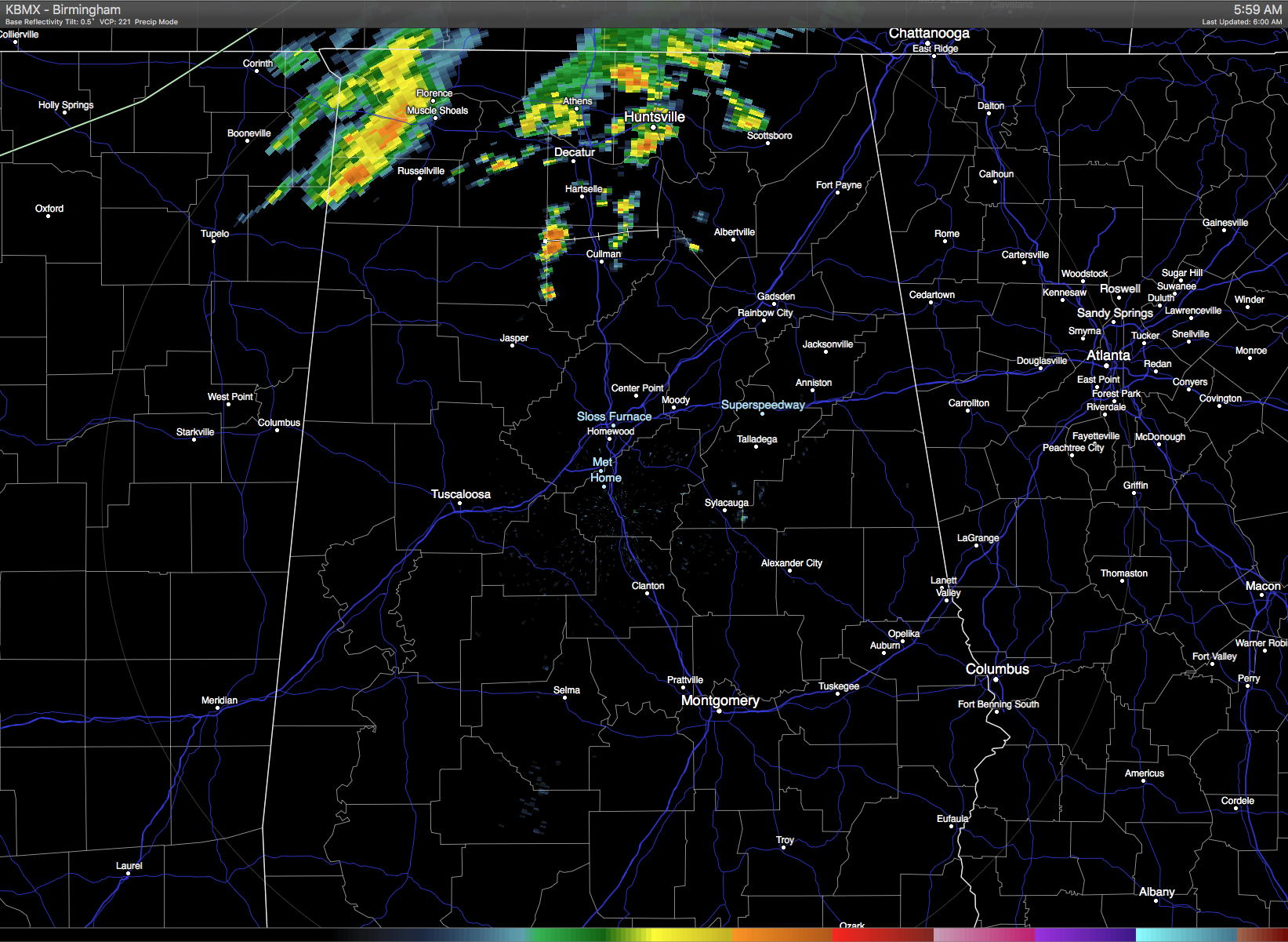
Much of the northern half of Alabama is waking up to a cloudy sky while the southern half of the state remained mostly clear. Showers were a bit more active this morning across the Tennessee River Valley ahead of a cold front sinking slowly southward into the Southeast US as the strong upper trough moves through the Great Lakes region. I expect to see showers and storms become numerous again across much of Central and North Alabama today as many of us will see measurable rain. The presence of more clouds and numerous showers should help to keep temperatures confined to the upper 80s for highs.
For beachgoers, there is going to be a standard summer pattern with more sun than clouds, but there will be those daily chances for showers and thunderstorms in the forecast. Highs along the beach will be in the upper 80s with overnight lows in the upper 70s. The sea water temperature at the Dauphin Island Sea Lab was 87 degrees. See the complete Gulf Coast 7 Day Planner here.
The threat for severe storms is somewhat limited over the next three days. There is a marginal risk today along the Mid-Atlantic States northward across eastern Pennsylvania into New York. No areas of severe weather are outlined on Monday. By Day 3 or Tuesday there is a large area of marginal risk from Kansas northward to Minnesota.
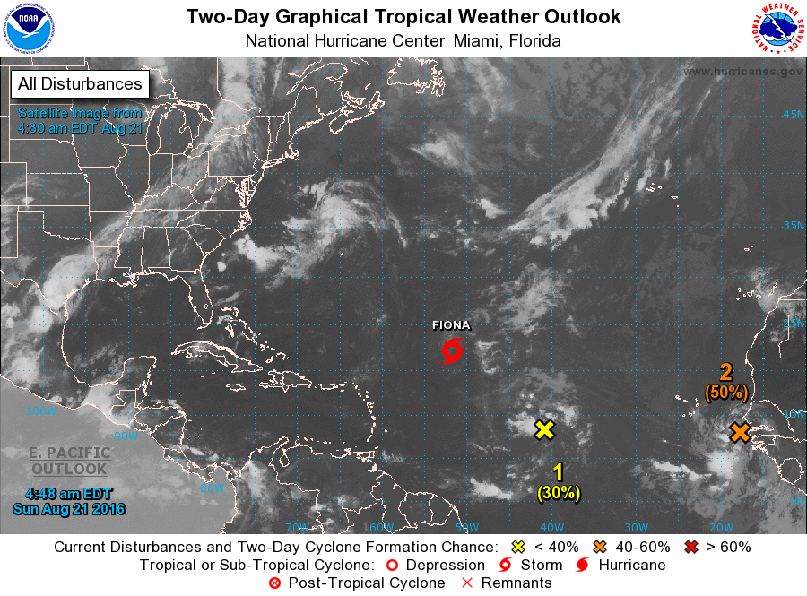
But the tropics are alive! Fiona has managed to defy forecasters by maintaining her strength at tropical storm force. Fiona had entered a region of increased westerly shear, so the low level center has become clearly exposed. The track will take the storm westward before recurving to the north around Bermuda. The intensity is expected to fall off on Tuesday as the storm drops into the depression category.
The area about 1200 miles east of the Lesser Antilles, Invest 99L, is beginning to look a little less ragged and has a 60 percent chance of becoming a tropical storm in the next five days as it enters an area with conditions more favorable for development. Long range track is still suggesting it may reach the Bahamas late in the week. Invest 90L is looking fairly good as it emerges from the African continent. Model guidance is suggesting this storm will move west for the next couple of days before turning more northwestward into the Central Atlantic following along more closely to Fiona.
The upper trough responsible for bringing the front into the US will move into New England on Monday putting an end to the forward progress of the front. GFS MOS guidance has backed off on bringing the dew points down as much, so the front may stall out closer to Central Alabama than South Alabama. It still looks like we will see some drop off on the dew points, so I’m cautiously optimistic that Monday will be dry with showers mainly across South Alabama.
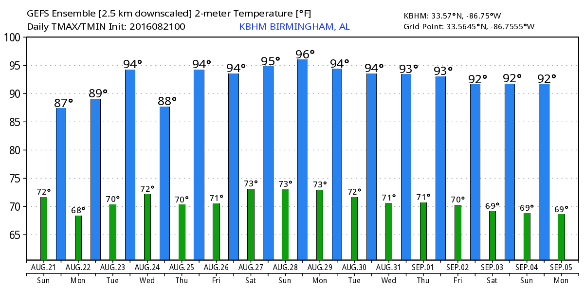
As the surface high slides across the Mid-Atlantic States on Tuesday we should see a northeasterly flow bring drier air into the Southeast US, so Tuesday still looks to be a dry day with slightly less humidity. But the upper ridge builds in quickly on Wednesday and the surface flow here will come back around to the south wiping out the drier air and bringing chances for showers and storms back into the forecast. It looks like showers and storms will be driven by the heating of the afternoon, so they should be fairly scattered with most people remaining dry. The highs Wednesday should be back around 90.
The upper ridge is forecast to remain in place over the Southeast US well into the weekend with a broad surface high in place. This keeps those daily chances for showers and storms in the forecast along with highs in the lower 90s. We will be contending with Invest 99L as it approaches the Bahamas. The GFS seems to be more bullish on bringing the tropical system into the Bahamas, stalling it, then taking it northeasterly into the Atlantic. The ECMWF, on the other hand, has little in the way of a tropical system in the Bahamas preferring to keep everything well out in the Atlantic. So a good deal of uncertainty as to the future course of Invest 99L.
Looking into voodoo country which is what we call the long range, the GFS features a large upper ridge across the southern tier of the US around August 31st. But that ridge breaks down around September 3rd with the development of a trough over the eastern half of the country. The trough does not last long with the ridge over the southwestern US pushing back into the eastern part of the country by September 5th. This would surely suggest that the heat is not yet behind us for the year.
James Spann will be back with the next edition of the Weather Xtreme Video first thing on Monday morning. You’ll find notes about the Alabama weather scene here throughout the day, so check back often. Be smart with the thunderstorms today, and don’t take any risks when lightning is occurring. Lightning death toll across the US is up to 27 and we don’t want any of our audience to become 28! Have a great day and Godspeed.
-Brian-
Category: Alabama's Weather
About the Author (Author Profile)
Brian Peters is one of the television meteorologists at ABC3340 in Birmingham and a retired NWS Warning Coordination Meteorologist. He handles the weekend Weather Xtreme Videos and forecast discussion and is the Webmaster for the popular WeatherBrains podcast.Subscribe
If you enjoyed this article, subscribe to receive more just like it.


