

Midday Nowcast: Hot & Humid Again in Central AL, While Gaston is Confused
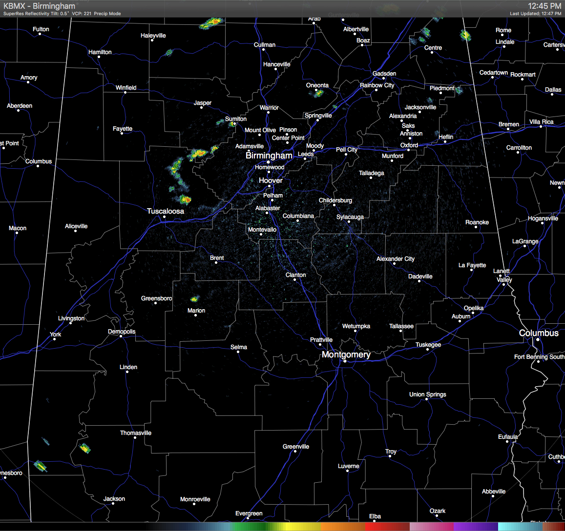
Skies are mostly clear across Central Alabama at this hour, but a few scattered showers have popped up on radar. Most of the shower activity was located over northeastern Tuscaloosa and southern Walker Counties, with a few spotty showers located near Oneonta in Blount County. These are slowly moving to the southwest.
TEMPERATURES AT THIS HOUR: Here is a list of temperature observations from across the area at this hour:
Birmingham 90
Tuscaloosa 90
Gadsden 90
Anniston 90
Cullman 90
Jasper 95
Alexander City 90
Selma 88
Montgomery 90
CODE YELLOW AIR QUALITY: The Air Quality Index for the Birmingham Metropolitan Area is in the “Code Yellow” for ozone and particulate matter 2.5. Unusually sensitive people should consider limiting prolonged outdoor exertion.
TODAY’S CLIMATOLOGY FOR BIRMINGHAM: The normal high for August 25th is 89, while the normal low is 68. The record high for today was set back in 1938 at 102. The record low was set back in 1916 at 57.
REMAINDER OF TODAY: Another hot and humid day expected for Central Alabama this afternoon, with a small risk for widely scattered showers and thunderstorms. Afternoon highs will be in the low 90 degrees for the most part, with a few places flirting with the mid 90s. The odds of any one spot getting rain today will be around one in four.
FRIDAY’S WEATHER: Much of the same news for tomorrow, as it looks like the typical summertime weather pattern will be in place for a while. It will be hot and humid, with partly to mostly clear skies, and a small risk for widely scattered afternoon showers and thunderstorms. Afternoon highs will mostly be in the low 90s, with a few spots reaching the mid 90s. The odds of any one spot getting rain will be around one in four.
HEADED TO THE BEACH: The weather looks great for the Central Gulf Coast from Gulf Shores to Panama City Beach through the weekend; about 8 to 10 hours of sun daily with only widely scattered showers and thunderstorms. Highs on the immediate coast will be in the upper 80s, with low to mid 90s inland. See a very detailed Gulf Coast forecast here.
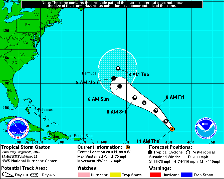
TROPICAL STORM GASTON: Gaston became a hurricane earlier this morning, but has just recently been downgraded back to tropical storm status. Gaston is expected to become a hurricane again as it moves northwest before making the curve back out into the open Atlantic well before reaching Bermuda and away from the Atlantic coast.
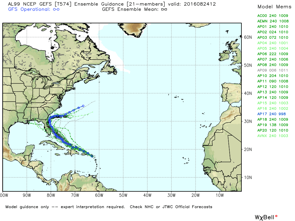
INVEST 99L: Of course, this is the tropical wave that currently has everyone’s attention. Currently, no low level circulation has been found within the wave, and until that circulation develops, inconsistency will be shown by the models because they do not know where or how to initialize the system. This is still very early in the game, and too early to know the track and intensity, if it develops at all. If it does develop, its name will be “Hermine” (her-MEEN).
ON THIS DAY IN 2005: Before making landfall in South Florida close North Miami Beach, Katrina became a hurricane with maximum sustained winds near 80 MPH. Over 1.3 million customers were without power, and losses were estimated from $600 million to $2 billion in the state of Florida. Eleven people were killed by Katrina in Florida.
THE BLOG IS ON TWITTER: Be sure to follow the Alabama Wx Weather Blog on Twitter. Just click here to start following our feed.
WEATHERBRAINS: This is the show all about weather featuring many familiar voices, including our meteorologists at ABC 33/40. You can listen anytime on the web, or on iTunes. You can find it here.
ADVERTISE WITH US: Deliver your message to a highly engaged audience by advertising on the AlabamaWX.com website. The site enjoyed 10.2 MILLION pageviews in the past 12 months. Don’t miss out! We can customize a creative, flexible and affordable package that will suit your organization’s needs. Contact Bill Murray at (205) 687-0782.
Category: Alabama's Weather
About the Author (Author Profile)
Scott Martin is an operational meteorologist, professional graphic artist, musician, husband, and father. Not only is Scott a member of the National Weather Association, but he is also the Central Alabama Chapter of the NWA president. Scott is also the co-founder of Racecast Weather, which provides forecasts for many racing series across the USA. He also supplies forecasts for the BassMaster Elite Series events including the BassMaster Classic.Subscribe
If you enjoyed this article, subscribe to receive more just like it.


