Mostly Dry in the Days Ahead
Central Alabama is waking up to a few clouds across the sky along with a couple of showers in the eastern sections of Alabama. Even with a few clouds we should see a fair amount of sunshine today. While the possibility for showers is not zero, there won’t be many showers around so the bulk of us will stay dry. Hermine is moving away from Alabama, albeit slowly, and an upper ridge is once again about to become the prevailing weather feature in our weather pattern for the week ahead. Highs today will climb to around 90 degrees.
Through the long holiday weekend, beachgoers will find plenty of sunshine with widely scattered showers and storms possible each day. Highs will remain in the upper 80s on the immediate coast with low 90s inland. The sea water temperature at Perdido Pass at Orange Beach was 85 degrees. See the complete Gulf Coast 7 Day Planner here.
Auburn will host Clemson this evening at Jordan-Hare Stadium with kickoff at 8 pm; the sky will be mostly fair with temperatures falling from near 77 degrees at kickoff to near 74 at the final whistle. Can’t say there is no chance of rain, but the risk of a shower is so small we won’t mention the possibility.
Alabama opens the season against Southern Cal in Arlington, TX, this evening at 7 pm CDT. The game is inside the “Jerry Dome”, but no weather issues for tailgaters. Clear weather is the story with temperatures falling from the lower 80s at kickoff into the 70s.
With the main storm track stuck along the US-Canadian border, the week ahead will be pretty quiet across the Southeast US. SPC has two marginal risk areas for Day 1 in the Dakotas and in parts of eastern Colorado, Northwest Kansas, and Southwest Nebraska. Day 2 there is a slight risk area in South Dakota and Nebraska. Day 3 that area shifts slightly eastward into Minnesota and Southeast South Dakota.
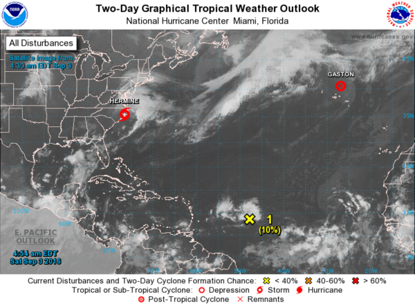
Tropics are still fairly active. It’s so strange to see a disturbance coming all the way from the African coast without development. What became Hermine did it and now we have another one that is doing it. Neither the GFS nor the ECMWF do anything with this second one. Since the GFS goes out further into the future, there is the sign of another one late in the forecast period.
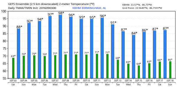
The threat of rain goes down after today. Aloft the upper ridge begins to build into the eastern half of the country Sunday and is the primary feature we will be dealing with for the next week or so. This ridge remains pretty strong through Thursday and then begins to be beaten down by strong troughs well to our north. This means that the hot weather is going to return. Highs will continue to be in the lower and middle 90s. GFS MOS guidance values for Tuesday through Thursday are back in the mid 90s and that looks pretty good with the upper ridge. After today, precipitable water values stay down through much of the week ahead, so shower risks will be quite low for Central Alabama.
Though the ridge is beaten down a bit by next weekend, it still remains dry and warm for us.
It’s hard to get more than diurnally driven showers while the storm track remains so far north of us. The GFS is signaling a change by September 13 as a strong upper closed low digs into the Central Mississippi River Valley. This could bring a reasonably strong cold front into the Southeast US with a substantial air mass change. We’ll watch for that feature in future runs. The GFS is also bringing a tropical disturbance into the Bahamas and near the East Coast of Florida by September 17th/18th. This feature may or may not be present in the next run, but we’ll keep a close eye on it to see whether or not there is any consistency in this feature.
I will be filling in for Meaghan Thomas on ABC 3340 New at 6 pm and 10 pm today, so you can tune in for the latest on your weather forecast. I plan to have the next Weather Xtreme Video posted here by 7 am or so on Sunday. Enjoy your day and perform at least one act of random kindness – you’ll fee good for it. Godspeed!
-Brian-
Category: Alabama's Weather


