

Dry and Warm in the Week Ahead
The upper air sounding from the Shelby County Airport yesterday evening showed a very large dry layer in place from 700 millibars to 200 millibars. There was also a pretty strong inversion just above the 700 millibar level. The dry air aloft should help to inhibit much in the way of convection except along the western and southwester counties of Alabama where moisture is deeper with less drying aloft. At the surface high pressure will spread into the Southeast coming in behind the exiting Hermine. Aloft, the upper ridge expands today and grows strong Monday into Tuesday.

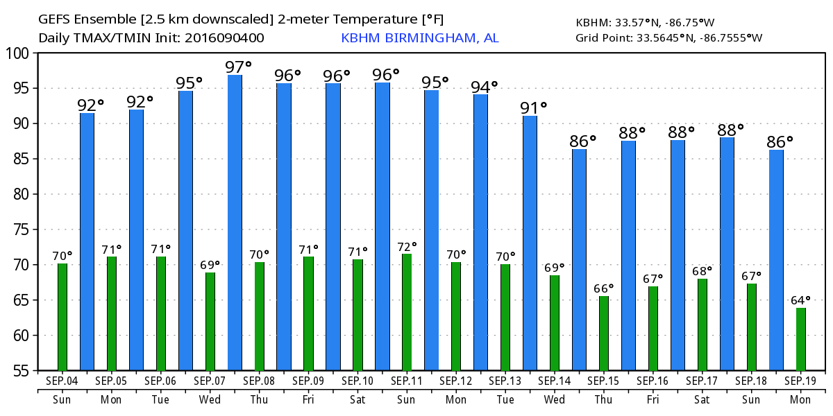
So for today look for only an isolated shower or thunderstorm mainly along the Alabama-Mississippi border driven by daily heating. As the ridge gets stronger today, we should see the afternoon highs climbs a bit with highs in the lower 90s along with plenty of sunshine.
For beachgoers, look for a mixture of sun and clouds with the sky mostly cloudy at times today. Showers/thunderstorms will be likely today. Showers become less likely on Monday and Tuesday and by Wednesday we should see dryer weather with lots of sun. Highs today and Monday will be around 86 warming into the upper 80s Tuesday through next weekend on the immediate coast with low 90s inland. The sea water temperature at Perdido Pass at Orange Beach was 87 degrees. See the complete Gulf Coast 7 Day Planner here.
Severe weather threat is confined to slight risk areas across the northern tier of the US. Day 1 has a slight risk area over parts of the Dakotas and much of the western two-thirds of Nebraska. For Day 2, the risk area shrinks and moves eastward into Minnesota and extreme eastern South Dakota. For Day 3, the slight risk area is centered mainly on Iowa.
We’re still watching Hermine in the Northeast Atlantic as it shows signs of strengthening slightly possibly bringing it back to hurricane strength late Monday and early Tuesday. Tropical storm warnings remained in place from coastal North Carolina to coastal Rhode Island. Storm surge and coastal flooding remain an issue until Hermine moves away from the coastline.
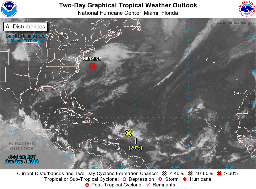
Still little sign of development from the area of disturbed weather approaching the Leeward Islands. It appears likely to track into the Caribbean, however, weather conditions remain poor for any development. Neither the GFS nor the ECMWF seem to do much with this system, but we must remain cautious because neither did much with Hermine until it finally arrived in the Gulf.
The upper ridge will be the main talking point in our weather pattern during the week ahead and even into next weekend. This means very little in the way of showers or storms and temperatures are going to remain in the 90s. Wednesday is likely to be the hottest day ahead with a rather large 594 contour covering practically all of the Southeast US. The ridge begins to wane on Thursday and Friday. A weak cold front is forecast to approach on Saturday and move into the Southeast US as it washes out on Sunday. Highs will still be in the lower 90s for the end of the week and start of the weekend.
Looking into voodoo country, that tropical system we saw yesterday in the Bahamas and coming up toward Jacksonville, FL, is gone. The GFS has gone much more bullish on the idea of several strong short waves moving through the eastern US around the 13th and again around the 16th. Both of these appear likely to bring colds into and through the Southeast US, so there is some hope for a break in the heat of early September.
James Spann will be back on Monday with the next edition of the Weather Xtreme Video. Enjoyed filling in for Meaghan Thomas on ABC 3340 last night, but I’m never fond of going on so late due to the games. But that’s just one of those things that goes with the territory. Enjoy your day and your Labor Day. Godspeed.
-Brian-
Category: Alabama's Weather
About the Author (Author Profile)
Brian Peters is one of the television meteorologists at ABC3340 in Birmingham and a retired NWS Warning Coordination Meteorologist. He handles the weekend Weather Xtreme Videos and forecast discussion and is the Webmaster for the popular WeatherBrains podcast.Subscribe
If you enjoyed this article, subscribe to receive more just like it.


