

Hot Afternoons; Pleasant Nights
DRY AIR HOLDS IN PLACE: First off, we note Birmingham’s official low this morning was 68 degrees… first time we have dropped below 70 degrees since July 1. And, in other positive news, the dew point has dropped into the upper 50s this afternoon, making the low 90s a little more comfortable. The sky is mostly sunny, and we have no rain on radar across the northern two-thirds of the state.
REST OF THE WEEK: No change. Dry air plus an upper ridge will mean mostly sunny days and fair nights. Highs will be in the 91-94 degree range, with lows between 66 and 69 degrees for most communities. The humidity will be fairly low, not as oppressive as what we experienced in August.
AIR QUALITY ALERT: A “code orange” alert has been issued for Jefferson/Shelby Counties for tomorrow due potential for ground level ozone.
THE WEEKEND: Saturday looks like another dry day; the sky partly to mostly sunny with a high at or just over 90 degrees. A weak surface front will drift in here Sunday, but with little moisture and no upper support, the chance of a shower for any one given spot looks very low and we won’t mention it in the forecast for now. Sunday’s high will be in the upper 80s.
And no real chance next week… generally dry weather with highs in the upper 80s and lows in the 60s. See the Weather Xtreme video for maps, graphics, and more details.
FOOTBALL WEATHER: High school games played under Friday night lights across Alabama will be rain-free with a clear sky; temperatures will fall from the mid 80s at kickoff into the 70s by the final whistle.
Alabama hosts Western Kentucky Saturday at Bryant-Denny Stadium for the 2016 home opener (2:30p CT kickofF)… the sky will be mostly sunny with 90 degrees at kickoff… dropping back into the mid to upper 80s by the end of the game.
Auburn will host Arkansas State at Jordan Hare Stadium Saturday evening (6:30p CT kickoff)… the sky will be clear with temperatures falling from 87 at kickoff into the upper 70s by the fourth quarter.
AT THE BEACH: Mostly sunny days and fair nights through the weekend from Gulf Shores over to Panama City Beach, with only widely scattered showers and storms around. Highs on the immediate coast will be in the upper 80s, with low 90s inland. See a very detailed Gulf Coast forecast here.
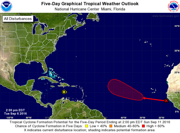
TROPICS: Hermine will loop around off the upper Atlantic coast of the U.S., and then head out to sea and fizzle out finally this weekend. A wave in the Caribbean is moving westward, but no development is expected due to harsh environmental conditions. Another wave is now coming off the coast of Africa; NHC gives that one a high chance of developing late this week and over the weekend, but it remains to be seen if this will become a threat to land.
WEATHER BRAINS: Don’t forget you can listen to our weekly 90 minute netcast anytime on the web, or on iTunes. This is the show all about weather featuring many familiar voices, including our meteorologists here at ABC 33/40. We will produce this week’s show tonight at 8:30 CT… you can watch it live here.
CONNECT: You can find me on all of the major social networks…
Facebook
Twitter
Google Plus
Instagram
I enjoyed seeing the senior adults today at Dwight Baptist Church in Gadsden… look for the next Weather Xtreme video here by 7:00 a.m. tomorrow…
Category: Alabama's Weather
About the Author (Author Profile)
James Spann is one of the most recognized and trusted television meteorologists in the industry. He holds the AMS CCM designation and television seals from the AMS and NWA. He is a past winner of the Broadcast Meteorologist of the Year from both professional organizations.Subscribe
If you enjoyed this article, subscribe to receive more just like it.


