

Tropical Storm Julia Forms To The East
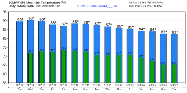
ALABAMA’S WEATHER TRENDING DRIER: With a tropical system to the east, and with Alabama being on the “dry side” of the circulation, looks like the coverage of afternoon showers will be smaller in coming days unfortunately. And, afternoon temperatures will need to be bumped up just a bit; we now project a high in the low 90s each day through Friday. The sky will be partly sunny, and the chance of any one spot getting wet will be only about one in five.
THE WEEKEND: With the ridge a little weaker, and a surface front north of the state, the coverage of scattered showers and thunderstorms will be a little higher, but again the tropical system east of the state complicates the situation, and overall the risk of rain will be lower than forecast earlier this week. Still, we will have a few showers and storms around both days, but they will be widely scattered. Expect a mix of sun and clouds Saturday and Sunday with afternoon highs remaining close to 90 degrees.
FOOTBALL WEATHER: The chance of a storm Friday night during the high school games is now lower. Still some risk of a shower or storm during the first half of the games, but they will be pretty isolated, meaning most stadiums will be dry. Temperatures will fall through the 80s.
Auburn will host Texas A&M Saturday evening at Jordan-Hare Stadium (6:30p CT kickoff)… a shower or thunderstorm is possible during the game, but not especially likely. Temperatures will fall from near 84 degrees at kickoff, into the upper 70s by the final whistle.
Alabama travels to Oxford to play Ole Miss Saturday (2:30p CT kickoff). The sky will be mostly cloudy, and a passing shower or storm is possible during the game. Temperatures will hover in the mid to upper 80s.
NEXT WEEK: The upper ridge holds, and the late summer pattern won’t change much. Unfortunately we see no really widespread, beneficial rain for now… just widely scattered afternoon showers and thunderstorms. See the Weather Xtreme video for maps, graphics, and more details.
JULIA: Advisories were initiated last night by the National Hurricane Center; the system is far Southeast Georgia, and drifting slowly to the north. Top winds are 40 mph, and the main threat will come from heavy rain and flooding, and a few isolated tornadoes in the broad zone from Savannah up to Charleston.
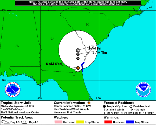
No direct impact on Alabama.
Elsewhere, Tropical Storm Ian in the Central Atlantic is moving north, and is no threat to land. A wave in the far eastern Atlantic near the Cape Verde Islands has some chance of slow development in coming days; just something to watch for now.
AT THE BEACH: About 6 to 8 hours of sunshine daily from Panama City Beach over to Gulf Shores with scattered showers and storms around through the weekend. Highs in the upper 80s on the immediate coast, with low 90s inland. See a very detailed Gulf Coast forecast here.
WEATHER BRAINS: Don’t forget you can listen to our weekly 90 minute netcast anytime on the web, or on iTunes. This is the show all about weather featuring many familiar voices, including our meteorologists here at ABC 33/40.
CONNECT: You can find me on all of the major social networks…
Facebook
Twitter
Google Plus
Instagram
Look for the next Weather Xtreme video here by 4:00 this afternoon… enjoy the day!
Category: Alabama's Weather
About the Author (Author Profile)
James Spann is one of the most recognized and trusted television meteorologists in the industry. He holds the AMS CCM designation and television seals from the AMS and NWA. He is a past winner of the Broadcast Meteorologist of the Year from both professional organizations.Subscribe
If you enjoyed this article, subscribe to receive more just like it.


