

Showers Today, Drier Monday
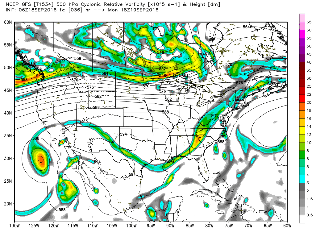
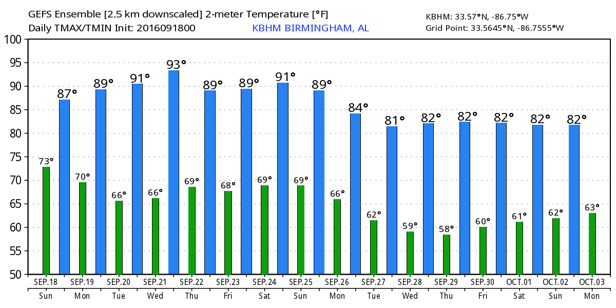
Clouds and fairly numerous showers helped to keep temperatures down across Central Alabama yesterday with 84 the official high in Birmingham. I’m looking for a similar day today as a cold front was poised to enter the northwest corner of the state this morning and should move steadily albeit slowly through the state today. Showers were seen on radar this morning mainly in Jefferson County, but showers will be likely today. Much like yesterday, deeper moisture to the south will keep South Alabama wetter than North and Central Alabama. Highs should again be in the middle 80s, just about on the money with the 30-year average high for the middle of September.
Thunderstorms will be likely for the beaches of Alabama and Northwest Florida today dropping off to only a slight chance by Monday. Full sunshine returns by Tuesday and for the week ahead. Highs along the beach will be in the middle and upper 80s for the next week.
SPC has only a marginal risk for severe storms in pockets across the US through Day 3. See the video for the specific graphics. The tropics remain active as Julia keeps kicking off the Southeast US Coast, Karl was expected to slowly gain strength as it roams the Central Atlantic, and an active area of disturbed weather just off the African Coast was moving into an area where conditions favor slow development.
The upper trough over the Mississippi River Valley this morning will move eastward today pushing the front steadily but slowly through Alabama. By midday Monday, the front should be east of the state as drier air pushes in from the north. With clearing sky, highs will rebound from the weekend with highs around 90 on Monday. Then we come back under the upper ridge which will be the prime feature for us for the week ahead. While moisture levels will be down with dew points falling to near 60, temperatures won’t be cool at all. Look for the highs to be in the lower 90s through Thursday.
Friday we have that weak upper low moving into Georgia from the Atlantic along with an increase of southerly or southeasterly flow at the surface. We’ll see some clouds and there will be a small risk for showers mainly driven by the heating of the afternoon. That weak upper low was not projected to move as far west as we saw yesterday, so most of us will stay dry. A big upper trough coming out of the Rockies on Saturday and Sunday will push a front across the Mississippi River Valley on Sunday. This should increase our chances for rain for Sunday and Monday as the front moves across the Southeast US.
Looking further out, a broad upper trough is forecast to remain in place across the eastern half of the country as we end September, but the upper air pattern slowly changes as we go into October with an upper ridge in place over the Mississippi River Valley by the 3rd of October.
Thanks for staying tuned to the blog. I’m excited to be emceeing the Ride For Kids once again this year at Barber Motorsports Park later this morning. Busy day since I will be filling in for Meaghan Thomas on ABC 3340 with the news at 5 and 10 pm. James Spann will be up next with the next edition of the Weather Xtreme Video first thing Monday morning. Have a great day and Godspeed.
-Brian-
Category: Alabama's Weather
About the Author (Author Profile)
Brian Peters is one of the television meteorologists at ABC3340 in Birmingham and a retired NWS Warning Coordination Meteorologist. He handles the weekend Weather Xtreme Videos and forecast discussion and is the Webmaster for the popular WeatherBrains podcast.Subscribe
If you enjoyed this article, subscribe to receive more just like it.


