Hot Weekend; Cooler Next Week
Let’s start with a quick recap of some new records yesterday established for Anniston, Tuscaloosa, Montgomery, Muscle Shoals, and Pensacola. At Anniston, the old record of 96 set in 1980 was broken with a high of 97. At Tuscaloosa, the old record of 97 set in 1980 was broken with a high of 98. Montgomery did nearly the same breaking the old record of 97 set in 1931 with a high of 98. And it was 94 in Pensacola tying the record high for yesterday set in 1998. The bad news is that there is little reason to expect our high temperatures today to be much different from yesterday. Record highs for today include Birmingham at 99 set in 1931, Tuscaloosa at 97 set in 1961, Anniston at 96 set in 1931, and Montgomery at 98 set in 1931, so we could see a couple of these records tumble today.
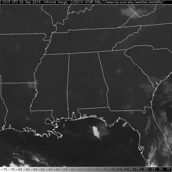
You know the pattern. We have a surface high along with an upper ridge in place across the Southeast US. The upper ridge bulges northward all the way to the Great Lakes area. But we are also eyeing a rather deep closed low and trough over the northern and central Rockies that will be making its way slowly eastward making an impact on our weather in the Monday-Tuesday time frame. For now satellite images shows clear skies across the state of Alabama with a few patches of clouds present over South Alabama. Look for highs today to once again reach the middle and upper 90s in the range of 94 to 98.
Football weather looks good albeit warm! Alabama hosts Kent State at Bryant-Denny Stadium with an 11:00 am CDT kickoff. The sky will be mostly sunny with temperatures rising from near 88 at kickoff to 95 degrees by the final whistle. It will be very, very hot in the east stands with direct sun while the west side will be more shaded. Sun screen a must for the game!
Auburn will host LSU at Jordan-Hare Stadium with a 5:00 pm CDT kickoff. The sky should be mostly clear with temperatures falling through the 80s.
Headed to the beach? About 8 to 10 hours of sunshine is expected daily on the coast from Dauphin Island to Panama City Beach through the weekend with only widely scattered storms expected through the middle of the upcoming week. Highs will be in the upper 80s on the immediate coast with lower 90s inland. See a very detailed Gulf Coast forecast here.
Little in the way of severe storms forecast by SPC with only a marginal risk in a narrow strip arcing from West Texas northward across western Iowa into the western Dakotas. The marginal risk area slides to Chicago and southern Lake Michigan for Day 2. Day 3 has no risk areas.
And the tropics remain active as they have been since about the 10th of September. Karl and Lisa are still plodding away. Karl is very close to Bermuda this morning but will be moving rapidly into the North Atlantic. Lisa remained a depression this morning and is expected to fizzle by Sunday. An area of disturbed weather with a broad low pressure field was south of the Cabo Verde Islands. This area is expected to move steadily at 20 to 25 mph across the South Atlantic. By about Wednesday or so, the area will be approaching the Leeward Islands where environmental conditions are expected to become favorable for intensification. Should this area become better organized then it would be named Matthew.
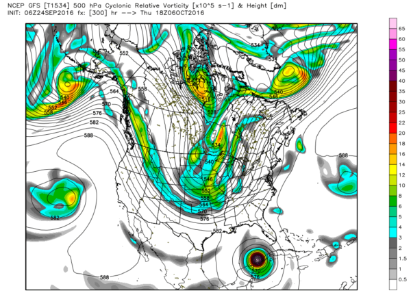
Following the GFS 06Z model run, the strong trough over the northern Rockies this morning will push eastward through Tuesday when it is expected to reach the eastern Great Lakes area. A surface low associated with this upper trough over the Dakotas this morning will move eastward reaching Southeast Canada by Tuesday. This will bring a cold front down into the Southeast US during the day on Monday. This will bring our best chances for rain over the next week or so, but it’s looking more and more likely that the showers or thunderstorms that do occur will be scattered, so not everyone will see rain. Moisture values ahead of the front are limited with precipitable water values around 1.5 to 1.7 inches.
Before all of that comes about, it is worth mentioning that there is a weak area of low pressure in the upper air flow over the Gulf Coast area of the florida Panhandle. This weakness is moving westward and is not expected to have much impact other than the potential for isolated showers along the Gulf Coast and into southern Alabama and southwestern Georgia.
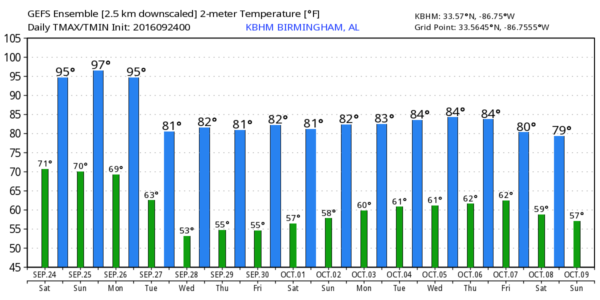
The front pushes further south into the Gulf on Tuesday bringing us under high pressure from over Texas. The upper flow goes northwesterly behind the upper trough, so we should be able to say goodbye to highs in the 90s with our highs finally dipping back into the 80s, much closer to our seasonal averages for late September and early October.
The upper ridge to our west on Wednesday will slowly slide east through the end of the week and into the weekend keeping us dry. Highs can be expected to stay in the lower and middle 80s – a nice change – and with lower humidity as dew points fall into the upper 40s and lower 50s. Wednesday appears likely to be our coolest morning with lows in the lower 50s, but those typically cooler locations could see morning lows reach the upper 40s. Won’t that feel nice?
Looking out into voodoo country, another strong trough moves into the western Great Lakes around October 4th followed by another, much deep trough around October 6th. And when you look at the maps, you cannot ignore the GFS projections of a strong tropical system coming into the Gulf of Mexico. Following the maps, this tracks back to that broad area of low pressure that is currently south of Cabo Verde Islands. That deep approaching trough on the 6th seems likely to force the tropical system in the Gulf to recurve into the Northeast Gulf Coast. Remember, we’re dealing with voodoo country here. But it is worth noting that the scenario the GFS is currently painting has some validity. We’ve seen numerous systems come across the South Atlantic this season without any development just as the GFS is suggesting with this system. Conditions in the Caribbean and Gulf as well as the immediate East Coast of the US is where we’ve seen development as we saw with Hermine and even with Julia. I’m certainly not waving hurricane flags just yet, but I think we’ll need to keep a close eye on future runs of the GFS to see what we might expect.
Thanks for tuning into the blog. I expect to post the next edition of the Weather Xtreme Video here by 7:30 am or so on Sunday morning. Wishing all the teams success in their games today, and certainly hoping the Florida State Seminoles can bounce back from the devastating loss last week. Stay cool and Godspeed.
-Brian-
Category: Alabama's Weather


