The Many Names of Tropical Systems and What They Mean
While I was attending the annual NWA Meeting in Norfolk, Virginia, back in September, one of the subjects that was brought up was the confusing names of tropical systems. No I am not talking about the human names that the systems are given, but the terms used in the different stages of the lifespan. Hermine had just recently dissipated before the trip, and that was the storm the focus was set on. During the lifespan of Hermine, it had seven different names…
Tropical Disturbance
Tropical Wave
Investigative Area (Invest 99L)
Tropical Depression
Tropical Storm
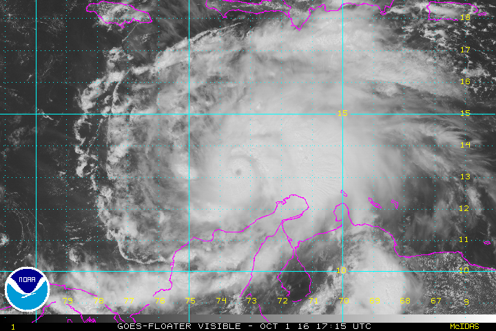
Hurricane
Post-Tropical Cyclone
There was a lot of confusion over what each name actually means. So here are those terms defined by the National Hurricane Center…
Tropical Disturbance:
A discrete tropical weather system of apparently organized convection, generally 100 to 300 nautical miles in diameter, originating in the tropics or subtropics, having a nonfrontal migratory character, and maintaining its identity for 24 hours or more. It may or may not be associated with a detectable perturbation of the wind field.
Tropical Wave:
A trough or cyclonic curvature maximum in the trade-wind easterlies. The wave may reach maximum amplitude in the lower middle troposphere.
Investigative Area (Invest):
A weather system for which a tropical cyclone forecast center (NHC, CPHC, or JTWC) is interested in collecting specialized data sets (e.g., microwave imagery) and/or running model guidance. Once a system has been designated as an invest, data collection and processing is initiated on a number of government and academic web sites, including the Naval Research Laboratory (NRL) and the University of Wisconsin Cooperative Institute for Meteorological Satellite Studies (UW-CIMSS). The designation of a system as an invest does not correspond to any particular likelihood of development of the system into a tropical cyclone; operational products such as the Tropical Weather Outlook or the JTWC/TCFA should be consulted for this purpose.
Tropical Cyclone:
A warm-core non-frontal synoptic-scale cyclone, originating over tropical or subtropical waters, with organized deep convection and a closed surface wind circulation about a well-defined center. Once formed, a tropical cyclone is maintained by the extraction of heat energy from the ocean at high temperature and heat export at the low temperatures of the upper troposphere.
Tropical Depression:
A tropical cyclone in which the maximum sustained surface wind speed (using the U.S. 1-minute average) is 33 knots (38 mph or 62 km/hr) or less.
Tropical Storm:
A tropical cyclone in which the maximum sustained surface wind speed (using the U.S. 1-minute average) ranges from 34 knots (39 mph or 63 km/hr) to 63 knots (73 mph or 118 km/hr).
Hurricane:
A tropical cyclone in which the maximum sustained surface wind (using the U.S. 1-minute average) is 64 knots (74 mph or 119 km/hr) or more. The term hurricane is used for Northern Hemisphere tropical cyclones east of the International Dateline to the Greenwich Meridian. The term typhoon is used for Pacific tropical cyclones north of the Equator west of the International Dateline.
Post-tropical Cyclone:
A former tropical cyclone. This generic term describes a cyclone that no longer possesses sufficient tropical characteristics to be considered a tropical cyclone. Post-tropical cyclones can continue carrying heavy rains and high winds. Note that former tropical cyclones that have become fully extratropical…as well as remnant lows…are two classes of post-tropical cyclones.
Remnant Low:
A post-tropical cyclone that no longer possesses the convective organization required of a tropical cyclone…and has maximum sustained winds of less than 34 knots.
Category: Met 101/Weather History
About the Author (Author Profile)
Scott Martin is an operational meteorologist, professional graphic artist, musician, husband, and father. Not only is Scott a member of the National Weather Association, but he is also the Central Alabama Chapter of the NWA president. Scott is also the co-founder of Racecast Weather, which provides forecasts for many racing series across the USA. He also supplies forecasts for the BassMaster Elite Series events including the BassMaster Classic.Subscribe
If you enjoyed this article, subscribe to receive more just like it.


