Some Clouds but Dry
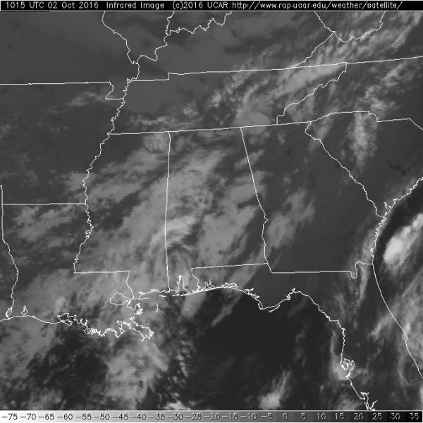
After a gorgeous Saturday with a beautifully clear Fall sky, clouds migrated into the Alabama sky overnight, so I expect to see a good mix of sun and clouds today. Temperatures will still be nice with highs in the lower 80s as our humidity also remains low. Radar was showing a few patches of some light precipitation, but the sounding from last night shows just how dry the atmosphere is, so little if any of that light precipitation will reach the ground.
For those headed toward the beach, the weather will be gorgeous with plenty of sun each day along with fair nights for much of the week ahead. Highs will be in the middle 80s while morning lows will be around 70. The sea water temperature at the Dauphin Island Sea Lab was 83 degrees. See the complete Gulf Coast 7 Day Planner here.
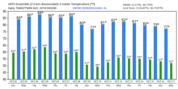
BARBER VINTAGE MOTORCYCLE FESTIVAL: We are a less than a week away from this big event that runs from Friday, October 7, through Sunday, October 9, at the Barber Motorsports Park. The weather is looking good with plenty of sunshine. Highs will be in the middle 80s Friday dropping back into the 70s for Saturday and Sunday. Morning lows will be in the 50s. Get ticket information right here.
SPC has a small marginal risk area for severe storms over eastern Idaho and Northwest Utah. Day 2 will see that marginal risk area move into the western Dakotas and Northwest Nebraska. Day 3 the risk jumps up to enhanced for portions of Kansas and Oklahoma surrounded by the standard slight risk area that stretches into Southeast Nebraska.
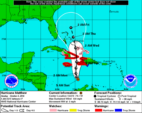
After a period of little definitive motion yesterday, Matthew seems to have made the turn toward the northwest which will gradually become more northerly today. Matthew was a major hurricane at Category 4 and will be approaching Jamaica, the eastern end of Cuba, and the western portion of Hispaniola tonight and Monday. The track after that will take the storm at a slightly reduce strength into the Bahamas. The longer range guidance still suggests that Matthew will move northward and northeastward dangerously close to the US East Coast. This potential trajectory will bring serious coastal flooding to much of the eastern seaboard from Florida to New England over the next week.
The trough that brought the taste of Fall to the Southeast US will move into New England through Monday leaving a slight troughiness behind. This will help to keep us in a sun/cloud mixture as the workweek starts. Temperatures will still be close to seasonal values with highs in the range of 81 to 84.
The upper ridge becomes the main player in our weather at mid-week as Matthew skirts along very close to the US East Coast. By Thursday and Friday we see the approach of another strong trough in the upper air pattern with a surface low and associated cold front moving out of the Central Plains states. By Saturday the trough is approaching the Mid Atlantic States as the front moves through the Southeast US essentially dry. We’ll see some clouds with it, however, it appears likely that moisture will be severely limited with the front, so we are not expecting to see any precipitation with it. Temperatures will drop back some with highs for next weekend in the 70s.
Week 2 or voodoo country looks active with another strong trough approaching the Mississippi River on October 11th. This may be our next really good shot at seeming some rain in the Southeast US. The GFS is setting up a broad trough over the eastern US around the 14th of October which should keep us on the cooler side for temperatures. But the cooler weather does not last long with another ridge coming into the picture by the 17th of October.
James Spann will be back on Monday morning with the next edition of the Weather Xtreme Video. In spite of the clouds, enjoy your day. Godspeed.
-Brian-
Category: Alabama's Weather


