

A Warmer But Still Dry Midday in Central Alabama

25 DAYS IN A ROW WITHOUT RAIN:
At the 1:00 PM hour across Central Alabama, skies are mostly sunny with a few high clouds overhead. Temperatures are about five degrees warmer than they were at this time yesterday, with all of the reporting stations in the area above 80 degrees. Of course with these mostly clear skies, there is no rain at all on radar. As matter of fact, the closest shower activity to the state is currently located in Southern Arkansas and Northern Louisiana.
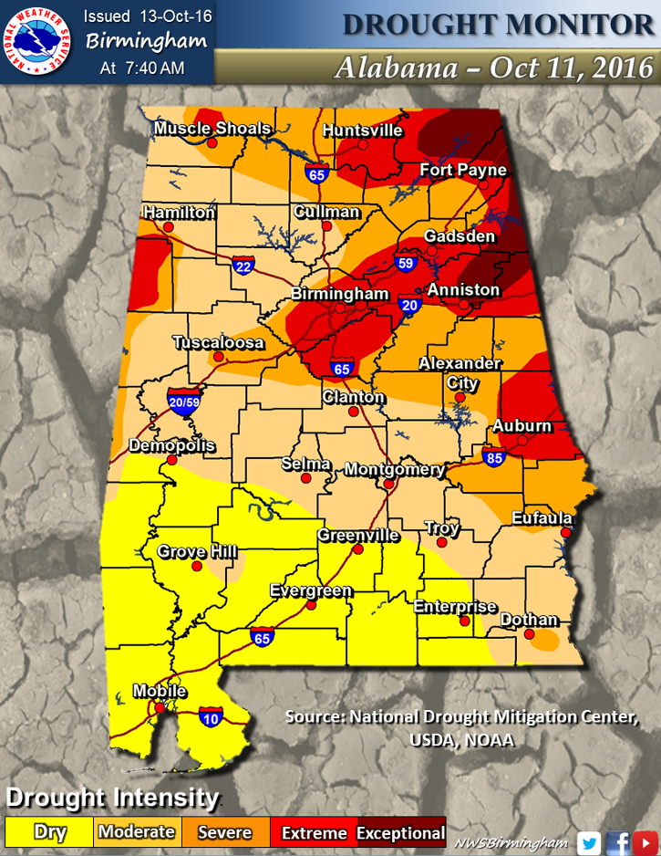
BURN BAN FOR 46 ALABAMA COUNTIES:
Governor Bentley signed a Drought Emergency Declaration yesterday due to extremely dry conditions. The declaration prohibits all outdoor burning in following counties in north and central Alabama: Autauga, Bibb, Blount, Calhoun, Chambers, Cherokee, Chilton, Clay, Cleburne, Colbert, Coosa, Cullman, Dallas, DeKalb, Elmore, Etowah, Fayette, Franklin, Greene, Hale, Jackson, Jefferson, Lamar, Lauderdale, Lawrence, Lee, Limestone, Lowndes, Macon, Madison, Marion, Marshall, Montgomery, Morgan, Perry, Pickens, Randolph, Russell, Shelby, St. Clair, Sumter, Talladega, Tallapoosa, Tuscaloosa, Walker, and Winston.
FIRE ALERT FOR ALL ALABAMA COUNTIES:
The Alabama Forestry Commission (AFC) has issued a Fire Alert for all counties in Alabama effective immediately. While under a Fire Alert, burn permits will be issued at the discretion of the State Forester. This Fire Alert will remain in effect until rescinded by the State Forester, at which time conditions will have changed sufficiently to reduce the occurrence and frequency of wildfires. The Commission is urging everyone to exercise all necessary safety precautions when doing any type of outdoor burning, and to call the Alabama Forestry Commission to obtain a burn permit. While under the Fire Alert, permits for outdoor burning in these counties will be restricted and issued on an individual basis.
TEMPERATURES ACROSS CENTRAL ALABAMA AT 1:15 PM CDT:
Birmingham 82
Tuscaloosa 84
Gadsden 81
Anniston 82
Cullman 80
Alexander City 82
Auburn 81
Selma 82
Montgomery 82
CODE YELLOW AIR QUALITY ALERT TODAY:
Particulate Matter 2.5 levels are high enough to raise the “Code Yellow” Air Quality Alert for the Birmingham metropolitan area today. Unusually sensitive people should consider limiting prolonged outdoor exertion.
NORMS AND RECS FOR TODAY IN BIRMINGHAM:
The normal high for October 13th is 76, while the normal low is 52. The record high for today was set back in 1953 at 89. The record low was set back in 1988 at 34.
REST OF TODAY:
A few clouds will move in during the afternoon and evening hours, but no moisture will be associated with those. Afternoon highs will reach the mid to upper 80s, and a few spots may touch 90 degrees. Overnight lows will be in the 50s.
TOMORROW’S FORECAST:
Another warm day in store for Central Alabama. Skies will be partly cloudy and afternoon highs will be in the mid to upper 80s, with a few spots hitting at or just above 90 degrees. There is a very slight risk for a few showers for the extreme northern parts of Central Alabama, as a short wave moves eastward across the area. There will not be much moisture involved with this feature, so if any rain falls at all, it will be meager at best.
FRIDAY NIGHT FOOTBALL:
Partly to mostly clear skies throughout the evening tomorrow, with temperatures falling from the mid 70s at kickoff, into the upper 60s by the final whistle.
HEADED TO THE NATIONAL SHRIMP FESTIVAL AND/OR THE BEACH:
One of the biggest events of the year kicks off at Gulf Shores today, and the weather could not be better.Sunny days, clear nights on the coast from Gulf Shores to Panama City Beach through the weekend, with highs in the 80s. See a very detailed Gulf Coast forecast here.


TROPICS:
The eye of Hurricane Nicole is now moving away from Bermuda, but strong winds and flooding will continue on the island for the next few hours. Maximum sustained winds for Nicole are currently at 115 MPH, and is moving to the northeast at 18 MPH. Rain totals on the island could reach up to 8 inches through the evening, and swells associated with Nicole will continue to affect the island for the next few days. Those swells will affect the east coast from the Carolinas northward creating dangerous surf and rip currents. Latest forecast track has Nicole continuing on its course to the northeast out into the open Atlantic, away from any land. The rest of the Atlantic Basin is quiet.
ON THIS DAY IN 1846:
A great hurricane tracked across Cuba, Florida, Georgia, the Carolinas, Virginia and Pennsylvania. The hurricane inflicted major damage along its entire path, which was similar to the path of Hurricane Hazel 108 years later. The hurricane caused great damage at Key West FL, and at Philadelphia PA it was the most destructive storm in thirty years.
THE BLOG IS ON TWITTER:
Be sure to follow the Alabama Wx Weather Blog on Twitter. Just click here to start following our feed.
WEATHERBRAINS:
This is the weekly netcast that’s all about weather featuring many familiar voices, including our meteorologists at ABC 33/40. You can listen anytime on the web, or on iTunes. You can find it here.
ADVERTISE WITH US:
Deliver your message to a highly engaged audience by advertising on the AlabamaWX.com website. The site enjoyed 10.2 MILLION pageviews in the past 12 months. Don’t miss out! We can customize a creative, flexible and affordable package that will suit your organization’s needs. Contact Bill Murray at (205) 687-0782.
Category: Alabama's Weather
About the Author (Author Profile)
Scott Martin is an operational meteorologist, professional graphic artist, musician, husband, and father. Not only is Scott a member of the National Weather Association, but he is also the Central Alabama Chapter of the NWA president. Scott is also the co-founder of Racecast Weather, which provides forecasts for many racing series across the USA. He also supplies forecasts for the BassMaster Elite Series events including the BassMaster Classic.Subscribe
If you enjoyed this article, subscribe to receive more just like it.


