There Is Rain Nearby at Midday, But We May Be Disappointed
26 DAYS IN A ROW WITHOUT RAIN IN CENTRAL ALABAMA:
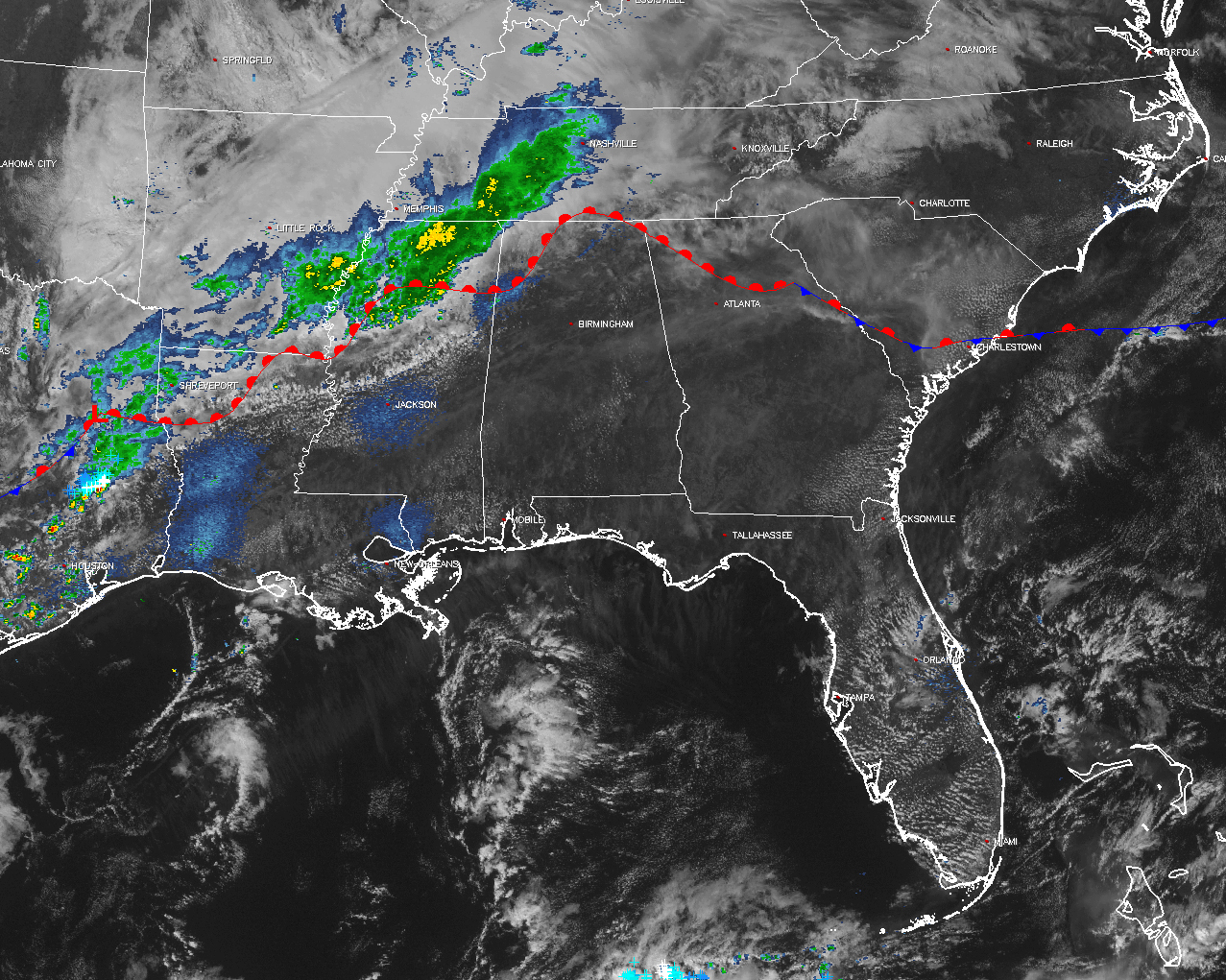
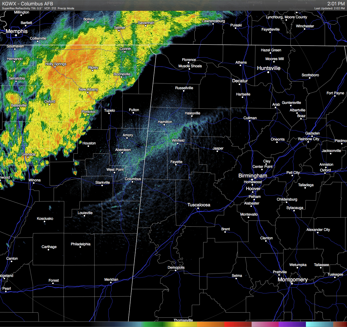
If you live in the very northwestern corner of the state, you are getting something that most of the state hasn’t seen in over three weeks, RAIN. Currently, there is a line of showers and thunderstorms, stretching along and behind a warm front, from North-Central Tennessee back to the southwest through Northwest Mississippi, Southeast Arkansas, Northwest Louisiana, and Southeast Texas. The line is currently progressing very slowly to the east. Unfortunately, the air over much of the state is still relatively dry as the dewpoints are still ranging in the 40s and 50s. The latest run of the HRRR shows the line not really progressing much at all, and dissipating by 10PM tonight. Looks like the only counties that will probably get rainfall today will be Lauderdale, Colbert, and Franklin. Good news for those, but bad news for the other 63 counties of the state who really need the rainfall as well.
BURN BAN AND FIRE ALERT:
A Drought Emergency was signed into effect by Governor Bentley on Wednesday, and this bans any outdoor burning for the northern two-thirds of the state. A Fire Alert remains in effect for the whole state. Only those counties outside of the Drought Emergency can burn outdoors after obtaining a burn permit from the Alabama Forestry Commission, but these will be restricted and issued on an individual basis. For more information, click here for more information..
TEMPERATURES ACROSS CENTRAL ALABAMA AT 1:30 PM CDT:
Birmingham 84
Tuscaloosa 84
Gadsden 84
Anniston 84
Cullman 81
Alexander City 84
Auburn 82
Selma 86
Montgomery 85
CODE YELLOW AIR QUALITY ALERT TODAY:
Particulate Matter 2.5 levels are high enough to raise the “Code Yellow” Air Quality Alert for the Birmingham metropolitan area today. Unusually sensitive people should consider limiting prolonged outdoor exertion.
NORMS AND RECS FOR TODAY IN BIRMINGHAM:
The normal high for October 14th is 76, while the normal low is 51. The record high for today was set back in 1984 at 89. The record low was set back in 1988 at 36.
REST OF TODAY:
Partly to mostly clear skies throughout the rest of the afternoon and evening hours today, with no chance of rain for most of the Central Alabama area except for a very small risk of showers in the extreme northwestern corner. Afternoon highs will range in the mid to upper 80s throughout the area, with overnight lows in the 60s.
FRIDAY NIGHT FOOTBALL:
Partly to mostly clear skies throughout the evening tonight, with temperatures falling from the mid 70s at kickoff, into the upper 60s by the final whistle.
ALABAMA FOOTBALL IN KNOXVILLE:
Kickoff will be tomorrow afternoon at 2:30 PM CDT at Neyland Stadium. Skies will be mostly clear with the temperatures at kickoff in the upper 70s and staying there throughout the game. Winds will be around 5 MPH out of the southwest. Looks like the chance of rain that was there earlier has now gone away in the latest model runs.
TOMORROW’S FORECAST:
Skies will be mostly clear to partly cloudy with a very slight risk for a scattered shower or two for areas east of I-65. Afternoon highs will be in the low to mid 80s. The odds for any one spot getting any rain will be around one-in-eight.
HEADED TO THE NATIONAL SHRIMP FESTIVAL AND/OR THE BEACH:
One of the biggest events of the year kicks off at Gulf Shores is underway, and the weather could not be better. Sunny days, clear nights on the coast from Gulf Shores to Panama City Beach through the weekend, with highs in the 80s. See a very detailed Gulf Coast forecast here.
TROPICS:
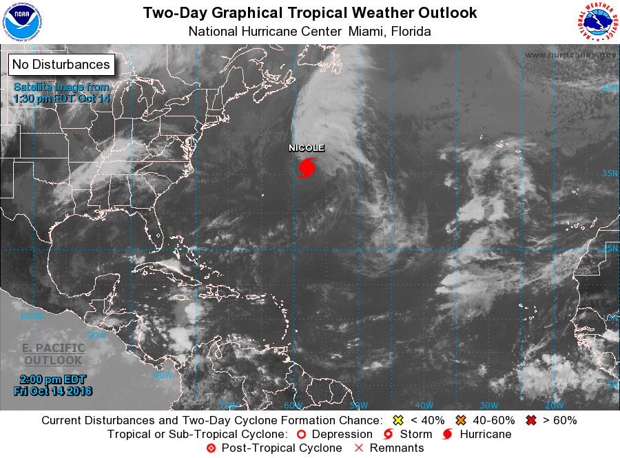
Hurricane Nicole currently has maximum sustained winds at 80 MPH and is moving off to the east-northeast at 18 MPH. It should become post-tropical later tonight and continue off into the open waters of the Atlantic. The rest of the Atlantic Basin is quiet.
ON THIS DAY IN 1989:
Thunderstorms produced severe weather over Michigan during the morning, and over New York State and Connecticut during the afternoon and evening hours. Thunderstorms spawned two tornadoes, and there were ninety reports of large hail or damaging winds, including seventy reports of damaging winds in New York State. A tornado at McDonough NY killed one person and injured three other people. Strong thunderstorm winds gusted to 105 mph at Somerset. Temperatures warmed into the 80s and lower 90s over much of the nation east of the Rockies, with eleven cities reporting record high temperatures for the date. Afternoon highs of 81 degrees at Beckley WV and Bluefield WV equalled October records.
THE BLOG IS ON TWITTER:
Be sure to follow the Alabama Wx Weather Blog on Twitter. Just click here to start following our feed.
WEATHERBRAINS:
This is the weekly netcast that’s all about weather featuring many familiar voices, including our meteorologists at ABC 33/40. You can listen anytime on the web, or on iTunes. You can find it here.
ADVERTISE WITH US:
Deliver your message to a highly engaged audience by advertising on the AlabamaWX.com website. The site enjoyed 10.2 MILLION pageviews in the past 12 months. Don’t miss out! We can customize a creative, flexible and affordable package that will suit your organization’s needs. Contact Bill Murray at (205) 687-0782.
Category: Alabama's Weather
About the Author (Author Profile)
Scott Martin is an operational meteorologist, professional graphic artist, musician, husband, and father. Not only is Scott a member of the National Weather Association, but he is also the Central Alabama Chapter of the NWA president. Scott is also the co-founder of Racecast Weather, which provides forecasts for many racing series across the USA. He also supplies forecasts for the BassMaster Elite Series events including the BassMaster Classic.Subscribe
If you enjoyed this article, subscribe to receive more just like it.


