Will It Ever Rain Again? Your Weather Xtreme Video for Saturday Morning 10/15
Pay no attention to my mention of October 16th on the video. It really is October 15th of course!
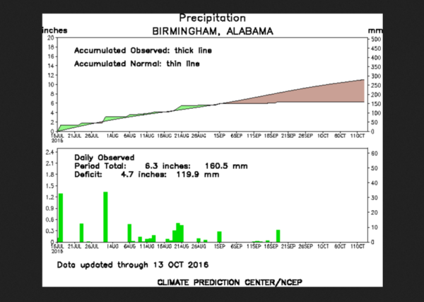
Friday marked the 26th consecutive day without rainfall at the Birmingham Airport. This is good enough to be tied for 12th place all time. It is also the longest streak since October 2000. It looks like it won’t rain again until at least Thursday or Friday, so our streak will probably reach 32 or 33 days. This will be enough to move the current streak into 5th place all time.
Here is the building rainfall deficit over the past 90 days at the Birmingham Shuttlesworth International Airport:
Rainfall was oh so close on Friday as a frontal system and upper level trough pushed a substantial area of moderate rain across northern Mississippi and into Northwest Alabama during the day. But the system ran out of steam as it neared our state. More accurately, it ran out of moisture, with precipitable water values across Alabama were generally less than one inch.
As the trough sweeps across the state late today and tomorrow, it will be accompanied by some cloudiness, but precipitation will be hard to find. Eastern sections will feel the influence of an easterly flow around the big high pressure system along the East Coast. Highs today will be warm in the west and cooler in the east, with afternoon readings in the upper 80s over near the Mississippi border with upper 70s to near 80 around the Georgia line.
Lows tonight will feel a little less comfortable, dropping only into the lower 60s as dewpoints rise. Those crisp, cool mornings of the past week will be a thing of the past for the time being. Tomorrow will feature partly cloudy to occasionally cloudy skies, with highs in the middle 80s.
A ridge of high pressure will build across the Deep South early in the week and temperatures will continue to be elevated. Midweek highs will be in the middle to upper 80s and lows will be in the lower 60s. Several spots will touch 90F WEdnesday or Thursday.
That ridge will break down by the end of the week, and showers and thunderstorms will re-enter the picture by late Thursday or Friday. This stronger system will mean that temperatures will back off several degrees.
Alabama travels to Knoxville to take on the Tennessee Volunteers in a key SEC match this afternoon. Skies will be partly cloudy. We have removed the chance of a shower. The kick off temperature will be around 78F falling into the middle 70s by the end of the game. Winds will be out of the southwest at 4-8 mph. The Auburn Tigers have a bye week.
BEACHBOUND? Boy, last weekend was just about perfect along the beautiful beaches of Alabama and Northwest Florida. It felt more like July in the restaurants as a big Columbus Day weekend crowd was enjoying the delicious seafood, but the morning lows in the 50s were quite comfortable along with the lower humidity. There is a slight chance of a shower along the beaches today and tomorrow, but highs will be in the lower 80s. Monday through much of Thursday looks absolutely perfect again however. A few showers will return for the weekend.
TROPICS: Nicole is exiting stage left over the North Atlantic. There are some hints at possible development by next weekend in the Bahamas, but the threat looks low and it wouldn’t affect our part of the world anyway.
Category: Alabama's Weather


