

Warm & Dry At Midday In Central Alabama Translates Into 29 In A Row
THE TOTAL WILL BE 29 DAYS AFTER TODAY:
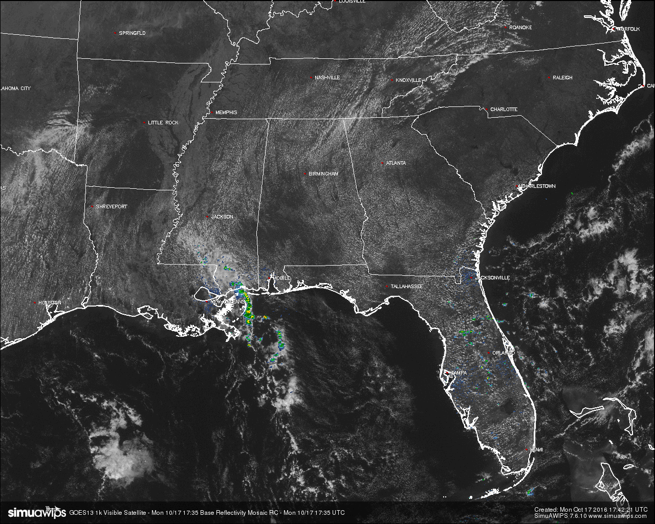
Yesterday was a close call at the Birmingham Airport as a few raindrops did fall, but it wasn’t enough to count as measurable. And once again, another dry and warm day is expected across Central Alabama for your Monday. Currently at the midday, skies are mostly clear with a few cumulus clouds out there, with nothing showing up on radar. The closest shower activity to the state as of now was located just off of the Eastern Louisiana Coast and along and south of the Mississippi Gulf Coast. Pretty much, the rest of the southeast is high and dry, except for the sea breeze showers that pop up just about everyday over the Florida Peninsula.
BURN BAN AND FIRE ALERT:
A Drought Emergency continues in effect, banning any outdoor burning for the northern two-thirds of the state. A Fire Alert remains in effect for the whole state. Only those counties outside of the Drought Emergency can burn outdoors after obtaining a burn permit from the Alabama Forestry Commission, but these will be restricted and issued on an individual basis. Click here for more information..
TEMPERATURES ACROSS CENTRAL ALABAMA AT 12:30 PM CDT:
- Birmingham 82
- Tuscaloosa 84
- Gadsden 81
- Anniston 82
- Cullman 78
- Alexander City 81
- Auburn 79
- Selma 82
- Montgomery 82
CODE YELLOW AIR QUALITY ALERT TODAY:
Particulate Matter 2.5 levels are high enough to raise the “Code Yellow” Air Quality Alert for the Birmingham metropolitan area today. Unusually sensitive people should consider limiting prolonged outdoor exertion.
NORMS AND RECS FOR TODAY IN BIRMINGHAM:
The normal high for October 17th is 75, while the normal low is 50. The record high for today was set back in 1897 at 91. The record low was set back in 2001 at 34.
REST OF TODAY:
Mostly clear skies for the rest of your afternoon and evening, with dry conditions, and afternoon highs in the mid to upper 80s. Tonight will be fair, with mostly clear skies and overnight temperatures in the 60s throughout the Central Alabama area.
TOMORROW’S FORECAST:
There is a chance we could break record highs in several locations as we will continue to have an upper high in control of our weather pattern. Skies will be mostly clear and afternoon highs will be in the mid to upper 80s, and I wouldn’t be surprised to see a place or two at or just above 90 degrees. Birmingham’s record high for tomorrow is 86F, and I believe that will be reset as the high will be a degree or two warmer.
HEADED TO THE BEACH:
Mostly clear and warm through Wednesday on the Alabama Gulf Coast, with afternoon highs in the low to mid 80s. A small chance of showers and storms sneak back in for Thursday and Friday, but clears out for the weekend. Highs on Thursday will be in the low 80s, but will drop back into the mid 70s for Friday through the weekend. See a very detailed Gulf Coast forecast here.
TROPICAL UPDATE:
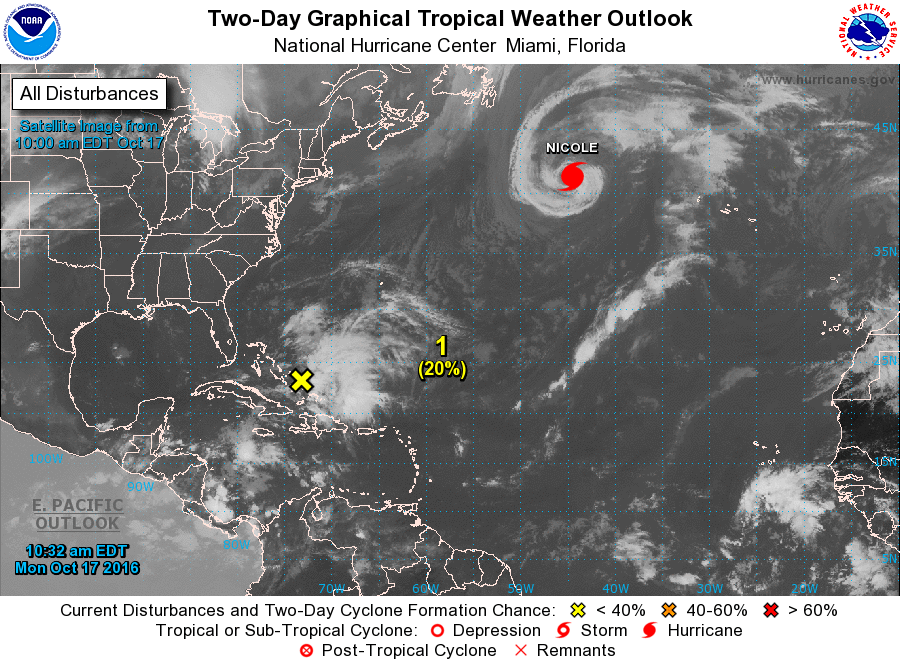
Nicole is a hurricane that refuses to quit. Maximum sustained winds were at 75 MPH (at 10:00 AM CDT), and movement was to the north-northeast at 9 MPH, out away for any land in the open Atlantic. She should become post-tropical by tonight or early into Tuesday morning.
There is an area of disturbed weather that is currently located over the Bahamas that possibly has a chance for further development during the later part of the week, as it will begin to drift north-northwestward. Currently, the National Hurricane Center is giving it a 50% chance of forming into a tropical cyclone within the next 5 days. We’ll keep our eye on it.
ON THIS DAY IN 1988:
Thunderstorms produced severe weather in the Middle Mississippi Valley and the Lower Ohio Valley. Severe thunderstorms spawned three tornadoes in Indiana, including one which injured four persons. Strong thunderstorm winds at Connerville IND caused three million dollars damage. Thunderstorms in Illinois produced hail two inches in diameter Colfax.
THE BLOG IS ON TWITTER:
Be sure to follow the Alabama Wx Weather Blog on Twitter. Just click here to start following our feed.
WEATHERBRAINS:
This is the weekly netcast that’s all about weather featuring many familiar voices, including our meteorologists at ABC 33/40. You can listen anytime on the web, or on iTunes. You can find it here.
ADVERTISE WITH US:
Deliver your message to a highly engaged audience by advertising on the AlabamaWX.com website. The site enjoyed 10.2 MILLION pageviews in the past 12 months. Don’t miss out! We can customize a creative, flexible and affordable package that will suit your organization’s needs. Contact Bill Murray at (205) 687-0782.
Category: Alabama's Weather
About the Author (Author Profile)
Scott Martin is an operational meteorologist, professional graphic artist, musician, husband, and father. Not only is Scott a member of the National Weather Association, but he is also the Central Alabama Chapter of the NWA president. Scott is also the co-founder of Racecast Weather, which provides forecasts for many racing series across the USA. He also supplies forecasts for the BassMaster Elite Series events including the BassMaster Classic.Subscribe
If you enjoyed this article, subscribe to receive more just like it.


