

Beautiful But Dry at Midday Across Central Alabama
A BEAUTIFUL AND DRY MIDDAY ACROSS CENTRAL ALABAMA:
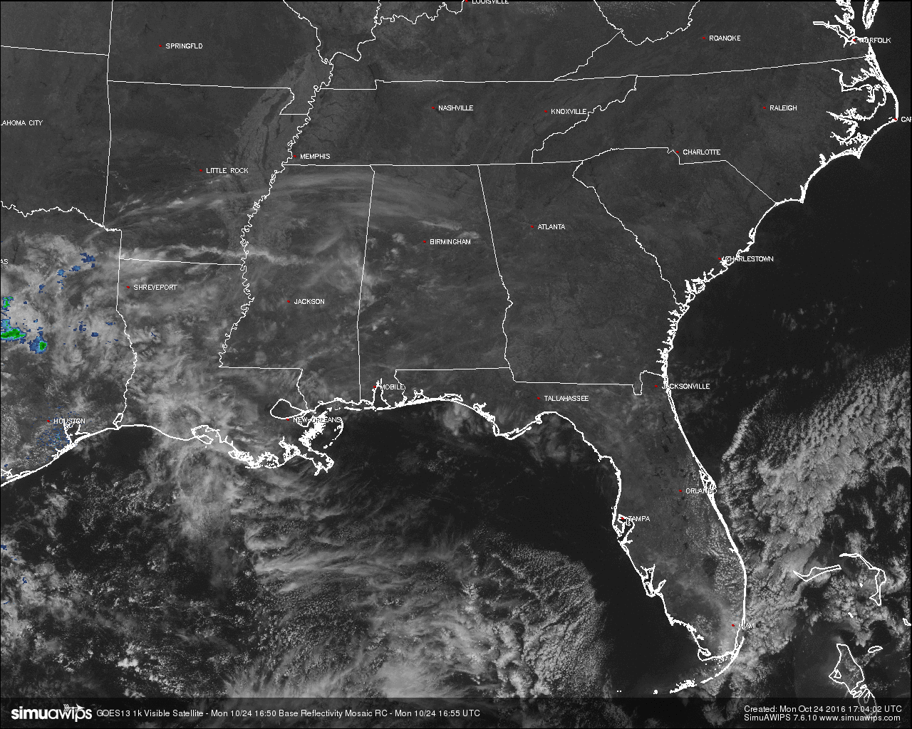
For those of you who love the beautiful blue skies and the nice temperatures outside, then you are in for a great treat at midday on this Monday. If you are looking for any raindrops falling from the sky today, you will be greatly disappointed. Skies across the area are mostly clear with only a few high thin cirrus clouds floating overhead. Looking at satellite and radar across the southeastern United States, the only precipitation that can be found is back into the east-central parts of Texas. No rain to be found any closer to us.
BURN BAN AND FIRE ALERT:
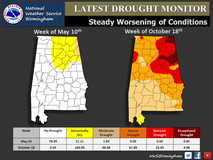
A Drought Emergency continues in effect, banning any outdoor burning for the northern two-thirds of the state. A Fire Alert remains in effect for the whole state. Only those counties outside of the Drought Emergency can burn outdoors after obtaining a burn permit from the Alabama Forestry Commission, but these will be restricted and issued on an individual basis. Click here for more information.
TEMPERATURES ACROSS CENTRAL ALABAMA AT 12:00 PM CDT:
- Birmingham 78
- Tuscaloosa 74
- Gadsden 78
- Anniston 78
- Cullman 74
- Alexander City 77
- Auburn 76
- Selma 75
- Montgomery 78
AIR QUALITY:
Both Ozone and Particulate Matter 2.5 levels will be below criteria to raise an Air Quality Alert for the Birmingham metropolitan area today. No actions needed.
NORMS AND RECS FOR TODAY IN BIRMINGHAM:
The normal high for October 24th is 72, while the normal low is 48. The record high for today was set back in 1927 at 86. The record low was set back in 1937 at 30.
REST OF TODAY:
With high pressure centered over the western part of Central Alabama, skies will remain mostly sunny through the remainder of the afternoon and evening hours, with skies clearing out by the night time. Afternoon highs will reach the low 80s for much of the area, with a few places in the southern parts of the area reaching the mid 80s. Overnight lows will fall into the upper 40s to low 50s.
TOMORROW’S FORECAST:
Much of the same story for Tuesday… The sun will be out in full force and afternoon highs will reach the upper 70s to the mid 80s across the area. A cold front will move across the area during the pre-dawn through the morning hours, but no moisture is associated with it, and will only drop the temperatures by a degree or two.
ANY RAIN AHEAD:
Unfortunately, any chance of a decent rainfall looks slim to none through the. We will have a small risk of a shower or two on Thursday, but if any rain falls it will not be enough to make a dent into our deficit for the year. We’re now up to 36 consecutive days without measurable rainfall at the Birmingham Airport, and the outlook looks likely that we could end the month of October with only a trace of rain.
HEADED TO THE BEACH:
Sunny days, fair nights on the coast through the week and weekend. Highs around 80 and lows in the 60s. See a very detailed Gulf Coast forecast here.

TROPICAL UPDATE:
Tropical cyclone formation is not expected during the next 5 days across the Gulf of Mexico, Caribbean Sea, and the North Atlantic Ocean.
ON THIS DAY IN 2005:
Hurricane Wilma reached the U.S. coastline near Everglades City in Florida with maximum sustained winds near 120 mph. The hurricane accelerated across south Florida and the Miami/Fort Lauderdale area, exiting the coast later the same day. There were 10 fatalities in Florida, and nearly 6 million people lost power, the most widespread power outage in Florida history. Preliminary estimates of insured losses in Florida were over $6 billion, while uninsured losses were over $12 billion.
THE BLOG IS ON TWITTER:
Be sure to follow the Alabama Wx Weather Blog on Twitter. Just click here to start following our feed.
WEATHERBRAINS:
This is the weekly netcast that’s all about weather featuring many familiar voices, including our meteorologists at ABC 33/40. You can listen anytime on the web, or on iTunes. You can find it here.
ADVERTISE WITH US:
Deliver your message to a highly engaged audience by advertising on the AlabamaWX.com website. The site enjoyed 10.2 MILLION pageviews in the past 12 months. Don’t miss out! We can customize a creative, flexible and affordable package that will suit your organization’s needs. Contact Bill Murray at (205) 687-0782.
Category: Alabama's Weather
About the Author (Author Profile)
Scott Martin is an operational meteorologist, professional graphic artist, musician, husband, and father. Not only is Scott a member of the National Weather Association, but he is also the Central Alabama Chapter of the NWA president. Scott is also the co-founder of Racecast Weather, which provides forecasts for many racing series across the USA. He also supplies forecasts for the BassMaster Elite Series events including the BassMaster Classic.Subscribe
If you enjoyed this article, subscribe to receive more just like it.


