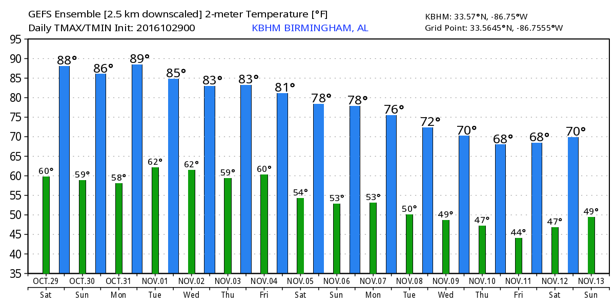
Record Warmth, Dry to End October
Alabamians waking up once again to a clear sky over the state with temperatures generally in the lower 50s in most locations. Satellite image showed nary a cloud, so we expect to see lots of sunshine today with highs climbing into the upper 80s. The 86-degree high yesterday at the Birmingham Shuttlesworth International Airport tied the record high for that date. Here are the records through the end of the month, some of which are likely to be tied or broken.
Location     Oct 29    Oct 30    Oct 31    Nov 1
Birmingham   86/1984   86/1984   87/1984   85/2000
Anniston     84/1984   86/1961   85/1961   85/1982
Tuscaloosa   86/1991   87/1961   88/1950   86/1950
Montgomery   87/2004   88/1984   90/1984   87/2004
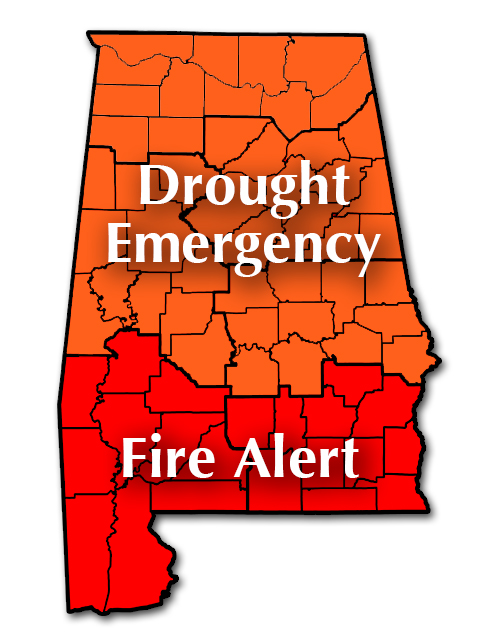
Conditions remain very dry in Alabama, so there is a Drought Emergency for counties in the northern two-thirds of the state. The Drought Emergency includes a No Burn Ban. A Fire Alert covers the counties of the southern third of the state where burning is discouraged.
Weather looking good for football today. Alabama is off this weekend. For the Magic City Classic in Birmingham where Alabama State plays Alabama A&M, the 3 pm CDT kickoff will be sunny with temperatures falling from near 86 degrees at kickoff into the 70s by the fourth quarter.
Auburn is on the road this weekend; they play at Ole Miss in Oxford with a 6:15 pm CDT kickoff. The sky will be clear with temperatures falling from near 75 at kickoff into the upper 60s by the fourth quarter.
Fore beachgoers, you will find sunny days and fair nights on the coast through the weekend and well into next week. Highs will be in the lower 80s and lows in the lower 60s. See a very detailed Gulf Coast forecast here.
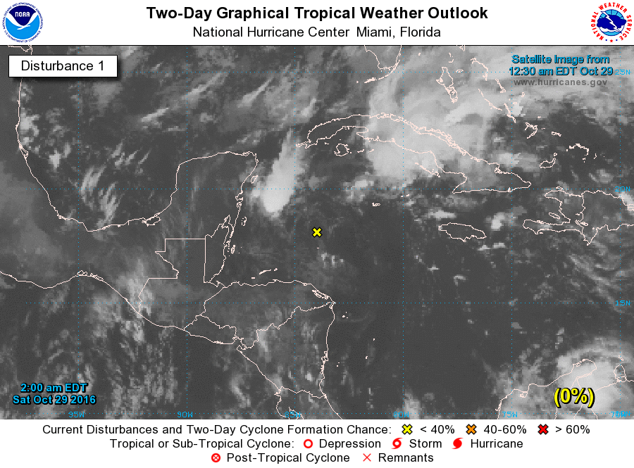
The SPC has no organized severe weather forecast anywhere in the continental US for the next three days. The tropics are fairly quiet with just one area of disturbed weather in the northwestern Caribbean affecting Cuba, the Florida Straits, and South Florida. This system is not expected to move much over the next couple of days and development is not likely due to strong upper level wind.
The surface high will ride with us for the weekend and much of the week ahead helping to keep any kind of moisture increase to a minimum. There is a strong upper ridge just to our west this morning the moves slowly across the eastern half of the country through midweek. By Thursday a strong upper trough will beat down the ridge somewhat, but the main storm track is still forecast to remain well to our north. So on Thursday we could see some mid and high level clouds passing through the Alabama sky, but the chance for any rain remains very low, too low to really put in the forecast.
Next Saturday the upper air pattern begins to show signs of a pattern shift. By Tuesday, November 8th, election day, the GFS is signaling a pattern shift with a broad trough over the eastern third of the country. This pattern should bring an end to the really warm weather for the Southeast US. But that shift does not last long according to the GFS with a return to an upper ridge by the 11th. By the 13th of November, a strong upper trough over the western Great Lakes has the potential to produce another shift in the upper air flow.
I hope you have an opportunity to enjoy the warm end of October weather today. I’m looking forward to a trip over to the Alabama Wildlife Center at Oak Mountain State Park for their Owl-O-Ween event. I plan to have the next edition of the Weather Xtreme Video posted here by 7:30 or so. Enjoy the day and Godspeed.
-Brian-
Category: Alabama's Weather
About the Author (Author Profile)
Brian Peters is one of the television meteorologists at ABC3340 in Birmingham and a retired NWS Warning Coordination Meteorologist. He handles the weekend Weather Xtreme Videos and forecast discussion and is the Webmaster for the popular WeatherBrains podcast.Subscribe
If you enjoyed this article, subscribe to receive more just like it.


