Warm, Dry Then What?
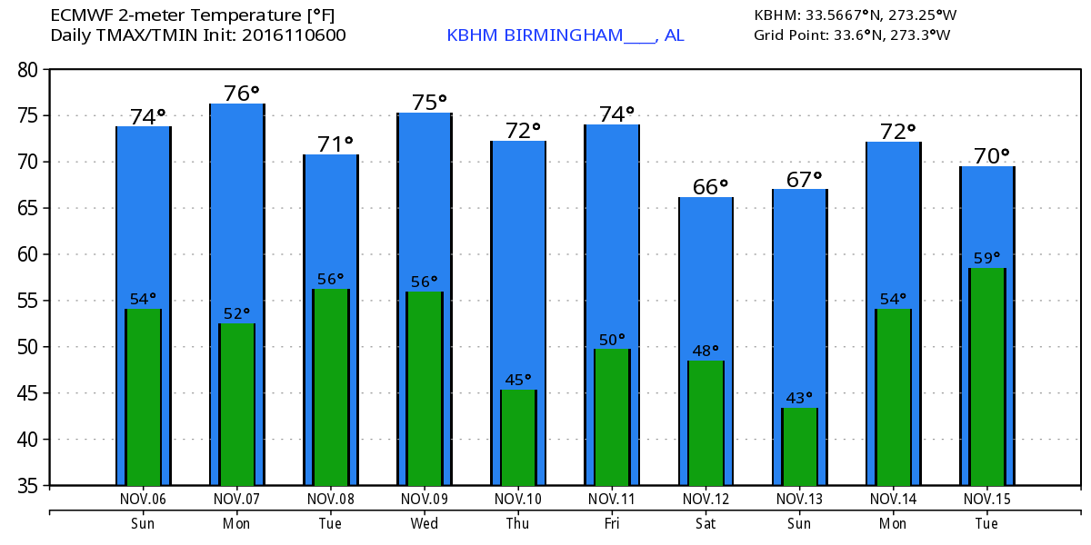
Alabamians waking up to a sky with lots of cirrus clouds this morning. And to the 49th day without measurable precipitation in Birmingham. Temperatures were cool, too, and our SkyWatcher at Black Creek reported a low of 37. Most airport observing sites were in the upper 40s. In spite of the cirrus clouds, we should see some sun today with highs climbing once again into the middle and upper 70s.
For those at the beach, you can expect to see a sunny day today, but the rest of the week appears likely to have a little less sun with chances for showers each day. Highs will be in the upper 70s today but drop back into the middle 70s for the rest of the week. See the complete Gulf Coast 7 Day Planner here.
Tropics on both coasts are quiet and expected to remain that way for the next five days. SPC has no areas of organized severe weather outlined for the next three days.
The ridge will remain the principal feature in our weather pattern through Monday, but then the forecast becomes a little murky as we deal with model differences. Highs Monday will remain in the middle and upper 70s but we could begin to see some additional clouds as moisture does return into the Lower Mississippi Valley area with a surface high off to our northeast over the Mid Atlantic states.
Tuesday the GFS is projecting the approach of a strong upper trough coming across the Great Lakes region extending southwestward into eastern Oklahoma. We should see some additional clouds Tuesday that will help to keep temperatures in the lower 70s. Moisture still remains in short supply, but with the precipitable water values coming up to around 1.4 inches, there may be enough along with the lift provided by the front to generate a few showers Tuesday evening or Wednesday morning.
At this point, the forecast models diverge in their solutions with the GFS more aggressive with the pattern and wetter than the ECMWF. The GFS cuts off a low from the strong trough moving through the eastern US on Wednesday over Arkansas. This trough moves over Central Mississippi on Thursday and off the Southeast US Coast on Friday. Precipitable water values are not especially impressive during this period, so I’m pretty sure we can rule out any kind of widespread rain. But the precipitable water values are forecast to be in the 1.3 to 1.5 inch range, so with a closed low just to our west, we could see scattered showers a possibility for Wednesday and Thursday. This is not likely to be a drought breaker, but some spots would be happy with even just a little rain. Keep in mind that the ECMWF has no closed low feature, so that model suggests only a small chance for showers early Wednesday and then dries things out.
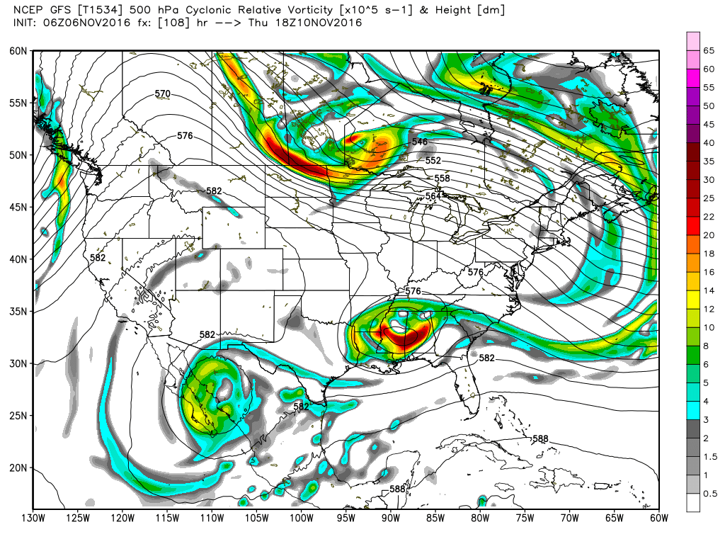
A reinforcing short wave comes across the Great Lakes on Friday according to the GFS clearing out the meager moisture Friday and drying us out for next weekend. Temperatures according to the GFS will be held down at mid-week due to clouds with highs around 70. By the end of the week, that reinforcing short wave could drop our temperatures back even more with readings by next weekend actually below our seasonal values for early-mid November. That would certainly be a change from the warmer-than-average days we’ve been experiencing.
Looking out into voodoo country, the GFS paints another strong trough coming into the Southeast US on Monday evening with the potential for some showers. The upper ridge returns on Friday the 18th of November, but by Sunday the 20th the GFS showed a very deep closed low over the Lower Mississippi Valley that could spell a big rain event for the Southeast US along with the potential for some severe weather. But you know how these features are that far out into voodoo country!
I had a great time visiting with the folks at Sawyerville in Hale County yesterday and appreciate their wonderful hospitality. James Spann will be back with the next edition of the Weather Xtreme Video bright and early on Monday morning. Hope you set your clocks back so you won’t be late for things today or tomorrow. Enjoy the day and Godspeed.
-Brian-
Category: Alabama's Weather
About the Author (Author Profile)
Brian Peters is one of the television meteorologists at ABC3340 in Birmingham and a retired NWS Warning Coordination Meteorologist. He handles the weekend Weather Xtreme Videos and forecast discussion and is the Webmaster for the popular WeatherBrains podcast.Subscribe
If you enjoyed this article, subscribe to receive more just like it.


