Rain Returns To Alabama Wednesday
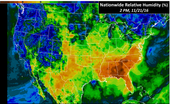
AS DRY AS IT GETS: Dewpoints are in the single digits now across parts of Central Alabama, and the relative humidity has dropped to 8 percent at the Shelby County Airport and Montgomery at 3:00 CT. In fact, the air across the Southeast U.S. is drier than the southwestern U.S. deserts…
Needless to say, there is no rain on radar, and the sky is cobalt blue. Temperatures are near 60 degrees at mid-afternoon. Tonight will be another cold one, with most places dropping into the 20s again early tomorrow morning.
The day tomorrow will be sunny and pleasant with a high between 67 and 70 degrees.
WEDNESDAY RAIN: An upper short wave/surface front will bring badly needed rain to Alabama Wednesday. Model guidance continues to suggests average amounts of about 1/4″, with potential for up to 1/2″ on the high end. There could be some thunder, but no severe weather is expected. The sky will be cloudy with daytime temperatures in the 60s.
THANKSGIVING DAY/BLACK FRIDAY: These two days will be dry and pleasant, lots of sunshine with highs between 67 and 71 degrees. Morning lows will be in the 40s.
THE ALABAMA WEEKEND: Slightly cooler air slips into the state Saturday; the high will drop into the low 60s. Dry air stays in place, and the sky will be sunny. Sunday will be partly to mostly sunny with a high in the mid 60s.
IRON BOWL: For the biggest college football game of the year in Alabama, Saturday for now looks like a perfect day for the game, with ample sunshine and a kickoff temperature in Tuscaloosa (2:30p at Bryant-Denny Stadium) near 62 degrees, falling into the 50s by the final whistle.
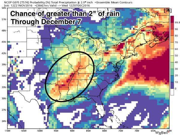
MORE RAIN EVENTS: Global models continue to show a strong signal for a good rain event Monday of next week, possibly beginning as early as late Sunday night. Rain amounts of 1/2 inch look likely, and yet another wave with rain shows up later in the week. After the “pattern flip” of last week, things are getting active as expected.
AT THE BEACH: Mostly sunny days, fair nights on the coast through the weekend, with just a small risk of a shower Thursday and Friday. Highs mostly in the 70s. See a very detailed Gulf Coast forecast here.
HELLO OTTO: A late season tropical storm with sustained winds of 50 mph has formed in the far Southwest Caribbean… Otto is expected to become a hurricane by the time it reaches the Central American coast Thursday. It will emerge into the eastern Pacific late Friday or Saturday… this is far from the U.S.
JAPAN QUAKE: A M6.9 quake rocked Fukushima this afternoon; tsunami warnings were issued for the Japan coast, but a tsunami is not expected to impact Hawaii or the U.S. West Coast.
WEATHER BRAINS: Don’t forget you can listen to our weekly 90 minute netcast anytime on the web, or on iTunes. This is the show all about weather featuring many familiar voices, including our meteorologists here at ABC 33/40. We will produce this week’s show tonight at 8:30p CT… you can watch it live here.
CONNECT: You can find me on all of the major social networks…
Facebook
Twitter
Google Plus
Instagram
Look for the next Weather Xtreme video here by 7:00 a.m. tomorrow…
Category: Alabama's Weather
About the Author (Author Profile)
James Spann is one of the most recognized and trusted television meteorologists in the industry. He holds the AMS CCM designation and television seals from the AMS and NWA. He is a past winner of the Broadcast Meteorologist of the Year from both professional organizations.Subscribe
If you enjoyed this article, subscribe to receive more just like it.


