Beautiful Weather for the Iron Bowl, but Hopeful for Rain Next Week
Good morning, Alabama, on a crisp and fall-like Iron Bowl Saturday!
We have been talking for days about some much needed rainfall reaching our rain buckets in these parts, and now we nervously await each and every model run to see if our smart pill machines still are conjuring up enough rain to dampen a dusty driveway.
Some hope is on the horizon for sure. Along with the rain might come some severe weather, but we will take the bad with the good and be ready. Let’s dig into the details.
COOL START: The cold front that pushed through Alabama on Thanksgiving Day is now pushing down the Florida Peninsula this morning. In its wake, it has left a cooler and drier airmass in place across our state. Temperatures are generally in the middle and upper 30s, with a few locations flirting with the freezing mark. The drier air is of course yielding very low dewpoints that are near the criteria for a red flag warning, but winds will not be brisk enough to warrant it. Still, the fire danger is extreme, so remember, there is a burn ban in effect. Report any unsafe actions and be vigilant.
IRON BOWL WEATHER: Bryant Denny Stadium in Tuscaloosa will be rocking today as Alabama and Auburn get together for their annual clash today at 2:30 p.m. The weather couldn’t be finer, with sunshine followed by a beautiful sunset on tap. Temperatures at kickoff will be around 63F, falling to near 50F by the final whistle. Winds will be out of the north at 6-8 mph.
FOR YOUR SUNDAY: Most areas along and north of I-20 will experience a freeze tomorrow morning, with many spots in the middle and upper 20s. Birmingham’s heat island of an airport may stay just above the freezing mark. Skies will go from sunny to partly cloudy during the day as our winds turn to the south. Dewpoints will start to slowly rise and high temperatures will peak 3-4 degrees warmer than those of today, around 65-68F.
SYSTEM 1: By tomorrow night, a powerful upper level system will be moving across New Mexico and Colorado. A powerful jet stream will be setting up from southern Arizona to the Texas Panhandle and up into Kansas. A few strong storms will fire up across the Southern Plains Sunday night into Monday morning, but the main severe weather will wait until Monday in the Arklatex.
By Monday morning, a strong surface low will be in the vicinity pf Nebraska or North Dakota. With a powerful Jetstream in the vicinity, storms are expected to increase in coverage and intensity from Northeast Texas into Louisiana and much of Arkansas. These storms will spread across Mississippi and into Northwest Alabama Monday evening. But the upper level dynamics will be lifting out to the northeast and the system will be weakening as it pushes into our state. A few strong storms are possible as the weakening line pushes east through the nighttime hours Damaging winds look to be the main threat.
Before the main event, a few showers could break out Monday during the day across the state as moisture increases on the back of a strong low level jet stream out of the Gulf of Mexico, which will be fully open for business. Highs Monday will be near 70F.
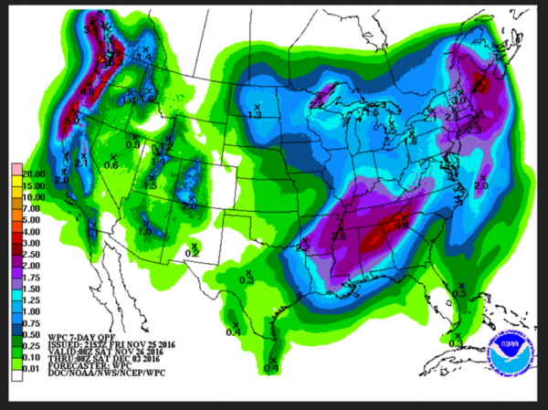
RAINFALL AMOUNTS (PART ONE): Keeping our fingers crossed, but by Monday afternoon, we hope much of Central and North Alabama will have averaged around one inch of rain.
SYSTEM 2: This forecast is based on the idea that the big upper trough will cut off into a big upper low over the Upper Midwest that will anchor it in place for awhile. This would keep Alabama in a moist southwesterly flow aloft with decent lift continuing through Tuesday into Wednesday. We would get a short break on Tuesday afternoon as some drier air works in at mid-levels, but indications are another round of rain and thunderstorms could break out in the I-59 corridor late Tuesday night into Wednesday afternoon. Another one to three inches of rain could fall. Strong storms are possible over southern parts of the area.
RAINFALL TOTALS: Two to three inches of rain looks possible on average with isolated amounts to four inches. None of this should result in flooding, but there could be runoff problems in spots.
TROPICS: Hurricane Otto made landfall Thursday just to the north of the town of San Juan de Nicaragua near the Costa Rica/Nicaragua border. Top winds were 110 mph, making Otto a Category Three storm.
GULF COAST WEATHER: A nice weekend is in store along the beautiful beaches of Alabama and Northwest Florida, with sunny skies and highs in the middle and upper 60s. Lows will be in the 40s. Much like here, things will be transitioning on Monday as the storm system approaches. Then, rain and storms will be a good bet Tuesday and Wednesday, tapering by Thursday morning, setting the stage for a nice weekend with sunny skies and highs in the 60s. Water temperatures are running in the middle 60s.
WEATHERBRAINS: This week, the panel will entertain Mike Wolfinbarger from WDT. Check out the show at www.WeatherBrains.com. You can also subscribe on iTunes. You can watch the show live at live.bigbrainsmedia.com You will be able to see the show on the James Spann 24×7 weather channel on cable or directly over the air on the dot 2 feed.
ON THIS DATE IN 1975: A waterspout moved onshore near Ewa Beach on the island of Oahu in Hawaii. Follow my weather history tweets on Twitter. I am @wxhistorian at Twitter.com.
Category: Alabama's Weather


