Cloudy and Very Windy At Midday, Possible Severe Storms Tonight
STRONG TO SEVERE STORMS POSSIBLE LATER TODAY & TONIGHT
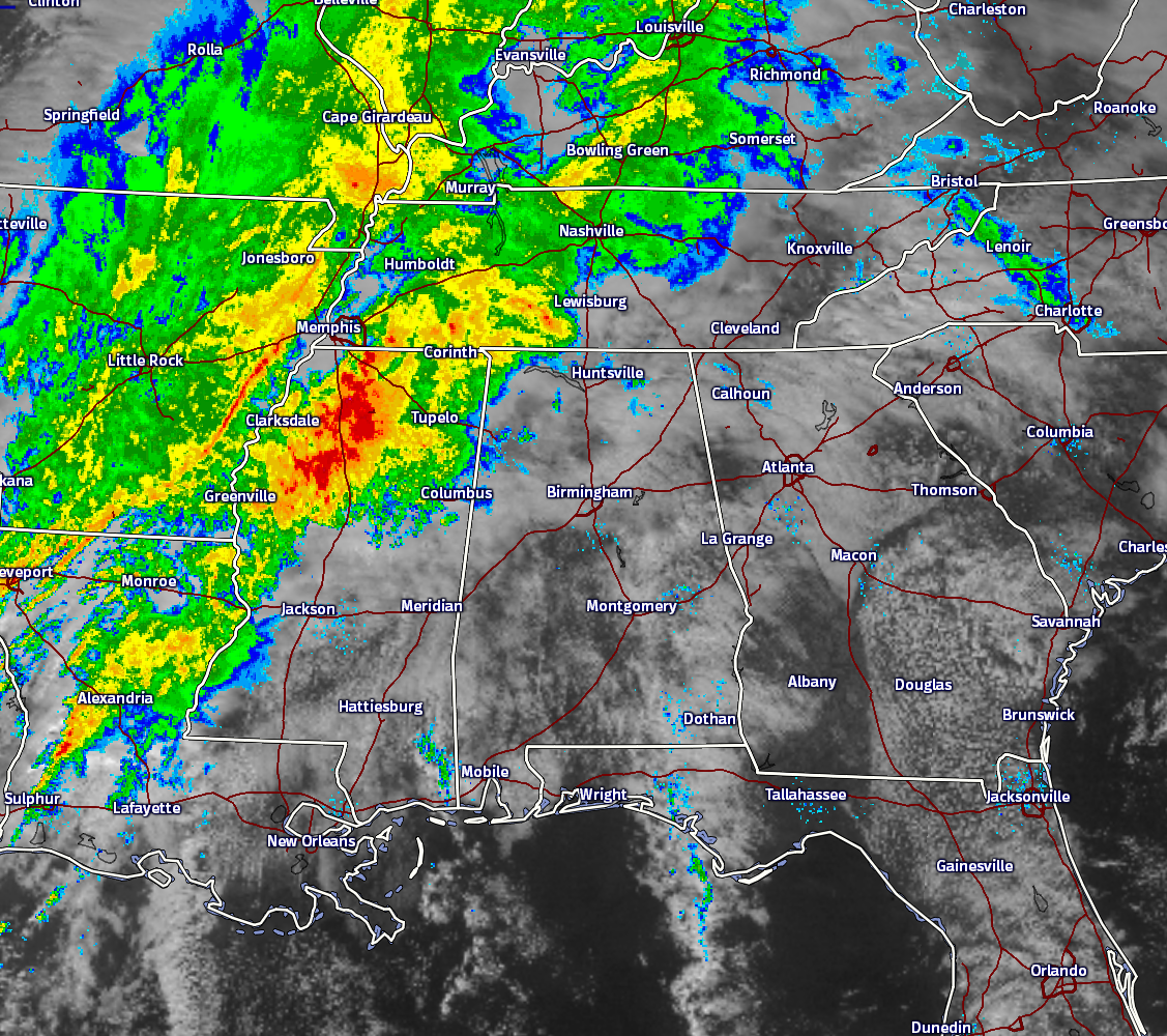
Skies are partly to mostly cloudy across Central Alabama at the noon hour, and winds are pretty gusty out there as well averaging 10 to 20 MPH out of the southeast, with gusts up to 25 to 30 MPH at times. Showers and storms are located ahead of a cold front that is draping back to the south-southwest from low pressure centered on the North Dakota/South Dakota border, down through Central Minnesota, to West-Central Iowa, to extreme Northwest Missouri, to extreme East Kansas, to East-Central Oklahoma, and to East-Central Texas.
Moderate rain and storms are located over North and North-Central Mississippi. Individual cells are moving to the northeast at a decent speed, but the overall movement to the east of the system is much slower. Rain has been falling over the extreme northwest corner of Alabama for the past several hours. At this point, there are no severe weather watches or warnings in effect for anyone in the southeast.
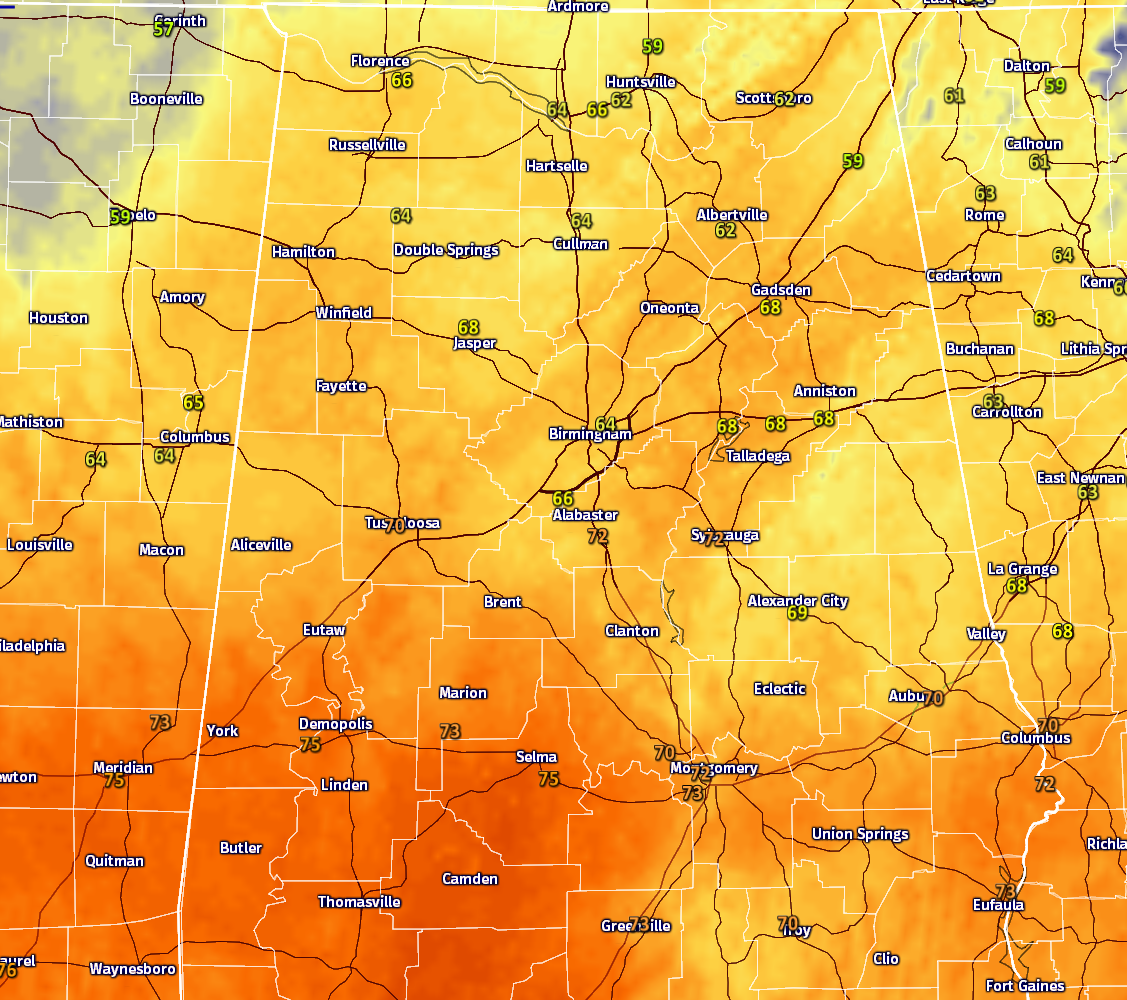
Temperatures across Central Alabama at 12:15PM are ranging from the mid 60s in the northwestern parts of the area, with upper 60s to low 70s in the south and southwestern parts of the area. The warm spot in the area is currently 75 degrees in Demopolis, with the cool spot at 64 in Birmingham, Cullman, and Haleyville.
BIRMINGHAM’S CLIMATOLOGY AND RECORDS
The normal high for November 28th is 60, while the normal low is 39. The record high for today was set back in 1908 at 77. The record low was set back in 1950 at 20.
LATEST DATA FROM THE U.S. DROUGHT MONITOR
The latest data from the U.S. Drought Monitor for the state of Alabama now shows that over 97% of the state is now classified under “severe” drought conditions, with 82% of the state under “extreme” drought conditions, and over 35% of the state under “exceptional” drought conditions. A Drought Emergency continues in effect, banning any outdoor burning for all counties in the state. Click here for more information. Be sure to conserve water as well, as the Birmingham Water Works remains in a “Stage 4 Drought Emergency.”
FOR THE REST OF TODAY
Skies will be mostly cloudy to cloudy for the remainder of the afternoon, and winds will be pretty strong out of the southeast averaging between 10-20 MPH, with gusts up to 30 MPH at times. Rain will slowly progress to the east throughout the afternoon and early evening hours. Highs will top out mostly in the 70s across Central Alabama.
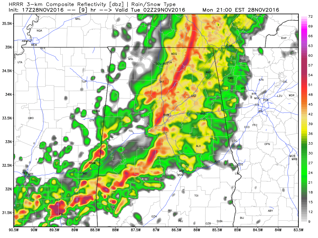
HRRR Model Run Valid at 9PM tonight.
Looks like the main window for action this evening and overnight areas will be from 6PM to 3AM. A squall line will move through the Tuscaloosa area sometime between 7-9PM tonight, the Birmingham area between 8-10PM, and the Gadsden/Anniston area between 9-11PM. Rainfall totals throughout the evening and overnight hours should be in the 1-2 inch range over most of the area, with higher totals possible.
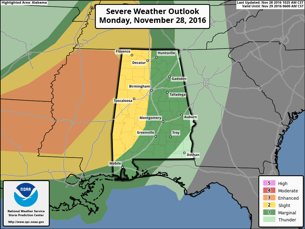
The latest update from the Storm Prediction Center has almost the whole western half of the state defined under a “slight risk” for severe storms throughout this evening into the early morning hours on Tuesday. The main threats will be from damaging straight-line thunderstorms winds, but a few tornadoes could be possible tonight especially in the southwestern parts of the area (west of I-65 and south of I-20/59). Instability numbers are highest in those parts of the area, and so are the significant tornado parameter values. Shear values are highest in the northern parts of the area, and shear may actually inhibit the development of supercells over the northern half of the area. With that being said, expect the unexpected when dealing with severe thunderstorms.
WHAT TO EXPECT FOR TUESDAY
A good part of the day on Tuesday will be dry for Central Alabama before another round of strong to severe storms move in during the evening to overnight areas. Skies will be partly to mostly clear throughout the morning and afternoon hours, and highs will make it into the mid and upper 70s, with a few spots in the extreme southern parts of the area in the low 80s.
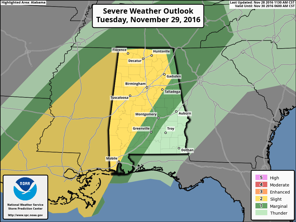
Much of West and West-Central Alabama has been defined under the “slight risk” for severe storms for Tuesday evening into the early morning hours of Wednesday. We’ll have to get through the first round tonight before we can get a clear idea on what will be expected for Tuesday, but as for now, main threats will be from damaging straight line winds, quarter size hail, and a few tornadoes.
Timing of tomorrow nights threat will be firmly nailed tomorrow, but expected windows of action will be 6PM to 6AM for western parts of the area (including Hamilton, Tuscaloosa, and Demopolis), midnight to 9AM for central parts (Birmingham, Clanton, and Montgomery), and 8AM to 2PM on Wednesday for the eastern parts (Alexander City, Auburn, and Troy).
FOR THOSE WHO ARE BEACHBOUND
Showers and storms will affect the coast Tuesday, again Wednesday night and finally Sunday over the next week. Highs will be in the 70s through Wednesday, which is quite nice for November. As we turn the page into December, things will cool down into the lower 60s.. Lows that are near 70 degrees Tuesday and Wednesday will fall back into the 40s by the end of the week. Water temperatures continue to be in the middle 60s. See a very detailed Gulf Coast forecast here.
UPDATE ON THE TROPICS
The Atlantic Basin is quiet as of now, and no development is expected throughout the week and weekend. The last day of the 2016 Atlantic Hurricane Season is November 30th.
ON THIS DAY IN 2005
A major winter storm affected parts of Nebraska and the Dakotas during the 27th-28th. Snowfall accumulations of 16-20 inches were observed in parts of eastern South Dakota, while wind gusts exceeding 60 mph also accompanied the snow, creating blizzard conditions. Thousands of power outages were caused by the combination of strong winds and heavy snow. In South Dakota, about 8,000 utility poles and 10,000 miles of transmission line were brought down by the storm.
NUMBER OF THE DAY: 0
The coolest low for the overnight period was recorded in Alamosa, Colorado, at 0 degrees. The warmest high temperature that occurred in the United States for yesterday was recorded in Edinburg, Texas, at 87 degrees.
FOLLOW THE BLOG ON TWITTER
Be sure to follow the Alabama Wx Weather Blog on Twitter. Just click here to start following our feed.
WEATHERBRAINS
This is the weekly netcast that’s all about weather featuring many familiar voices, including our meteorologists at ABC 33/40. This week, the “Brains” will be talking with Mike Wolfinbarger, from RadarScope. You can listen anytime on the web, or on iTunes. You can find it here.
Forecaster: Scott Martin (Twitter: @scottmartinwx)
Category: Alabama's Weather
About the Author (Author Profile)
Scott Martin is an operational meteorologist, professional graphic artist, musician, husband, and father. Not only is Scott a member of the National Weather Association, but he is also the Central Alabama Chapter of the NWA president. Scott is also the co-founder of Racecast Weather, which provides forecasts for many racing series across the USA. He also supplies forecasts for the BassMaster Elite Series events including the BassMaster Classic.Subscribe
If you enjoyed this article, subscribe to receive more just like it.


