Strong Storms Entering Northwest Alabama
Strong thunderstorms are entering Northwest Alabama at this hour.
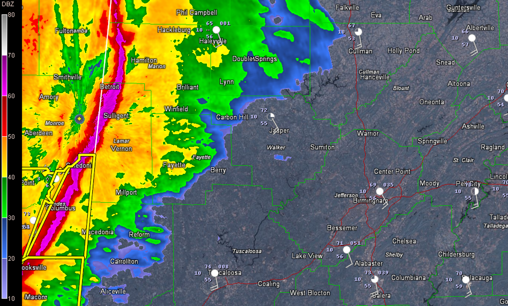
They extend from just west of Red Bay, Alabama to 12 miles west of Hamilton in Marion County to 8 miles west of Sulligent in Lamar County.
There is a bit of a kink in the line west of Hamilton, which indicates a higher probability of damaging winds and small spin up tornadoes.
There is certainly lots of low level shear in this area so a tornado is not out of the question. The NWS in Memphis has a severe thunderstorm warning in effect for Itawamba and Monroe Counties in Northeast Mississippi where that kink is located. They do have a TORNADO POSSIBLE tag on the warning.
There is also a bit of a bow echo look to the line, so damaging winds are certainly possible all along the line.
Multiple trees are reported down in north Amory and unincorperated areas between Hatley and Smithville. This storm will move into Marion County.
Multiple trees reported down in Leake and Jones Counties. This is west of Philadelphia and near Laurel.
Be in a safe place as these dangerous storms approach. Leave mobile homes for substantial structures. Do not be driving in these storms.
Category: Alabama's Weather, Severe Weather
About the Author (Author Profile)
Bill Murray is the President of The Weather Factory. He is the site's official weather historian and a weekend forecaster. He also anchors the site's severe weather coverage. Bill Murray is the proud holder of National Weather Association Digital Seal #0001 @wxhistorianSubscribe
If you enjoyed this article, subscribe to receive more just like it.


