Late Evening Look at the Alabama Weather Situation
“It ain’t over til it’s over,” said Yogi Berra. That statement somehow applies to the Alabama Weather Situation tonight.
We have been in a little lull as the supercell storms that formed over Mississippi and moved into Northwest Alabama this evening have now all lifted into the Tennessee Valley. A tornado is now on the ground near New market moving from Madison into Jackson County. There may be two tornadoes on the ground with that storm.
Now a new tornado warning was just issued for Winston County with a sister tornado warning being posted for Cullman County by the NWS Huntsville.
The damaging tornadoes in Colbert and Winston Counties came about at the low level jet spiked over the Tennessee Valley. That broad low level jet is pulling lots of Gulf moisture northward tonight across Louisiana, Mississippi and Alabama extending into southern Tennessee.
All you have to do is go outside tonight to feel the humidity. Dewpoints are 67F at Birmingham, 68F at Tuscaloosa and Calera and 70F at Pell City.
A warm front has lifted through most of the state at this hour, extending back southwestward to a surface low over northern Mississippi. It has become breezy over North and Central Alabama with winds
The upper level trough is swinging eastward and will energize this low as it lifts slowly northeastward. This will finally push the surface front eastward, shoving the moisture eastward. That moisture is becoming quite deep and rich, with precipitable water values over 1.5 inches over Mississippi, Louisiana and the northwestern half of Alabama.
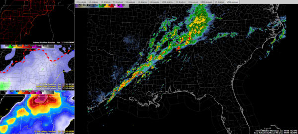
Showers and storms are firing and intensifying once again over eastern Louisiana and West Central Mississippi. There are four severe thunderstorm and tow tornadoes warnings now in effect to the west of Alabama. All of this activity will push into Alabama later tonight. The first strong storm could arrive in Lamar and Marion Counties before midnight.
I think we will see everything congeal into a long line of storms just after midnight. This line will advance slowly southeastward overnight, reaching the I-59 corridor by 4-5 a.m and getting out of East Alabama about 9-10 a.m.
Still hoping for 1.5 inches of rain in the Birmingham area, although that may be a little overdone. Flash flood warnings are in effect for much of Northwest Alabama and Northeast Mississippi.
Instability values will slowly drop through the predawn hours but will remain sufficient for tornadoes and severe thunderstorms with the advection of moist air off the Gulf and colder air aloft approaching. Low level helicity values will drop a bit, but there will be sufficient wind shear for organized storms tornadoes.
A tornado watch continues into the predawn hours for areas generally along and west of I-59.
Category: Alabama's Weather, Severe Weather


