At Midday, Active Weather Continues in Eastern Half of Central AL
CURRENT SEVERE WEATHER UPDATE FOR CENTRAL ALABAMA
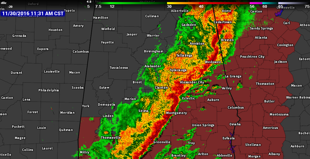
The northwestern parts of Central Alabama are starting to dry out after a very busy evening and early morning dealing with heavy rainfall and tornadoes. At 11:30 AM, the squall line is currently stretching from Fruithurst in Cleburne County, back to the south-southwest through Montgomery and down into Mobile. Currently at this point, there are no warnings in effect for anyone in Central Alabama, but torrential downpours and gusty winds, along with some small hail, are occurring in the line.
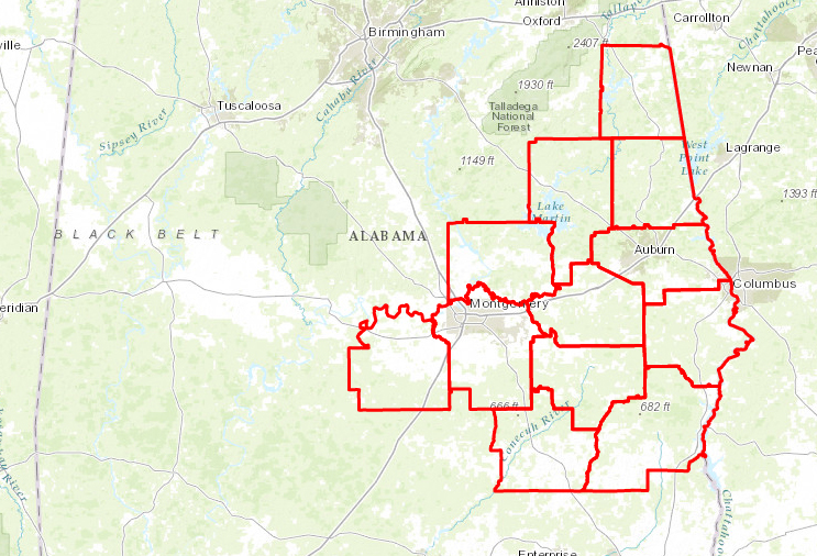
A new Tornado Watch has been issued until 5:00 PM CST for these counties in the southeast corner of the area: Barbour, Bullock, Chambers, Elmore, Lee, Lowndes, Macon, Montgomery, Pike, Randolph, Russell, and Tallapoosa. The primary threats for the watch area are scattered damaging wind gusts to 70 MPH, isolated large hail up to 1 inch in diameter, and a few tornadoes are possible.
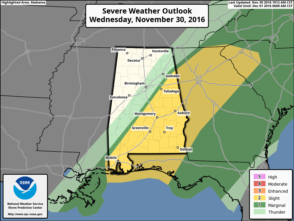
The Storm Prediction Center has much of the state east of a line from west of Mobile to Talladega defined in a “slight risk” for severe storms, with a quick drop off to no threat to the west of that line. The line of strong storms may intensify some this afternoon while moving eastward into Eastern Alabama, with an accompanying risk for damaging winds. Farther south, discrete storms are forming ahead of the line, and some of these storms will become supercells with the potential to produce a couple of tornadoes through the afternoon.
BIRMINGHAM’S CLIMATOLOGY AND RECORDS
The normal high for November 30th (my wife’s birthday) is 60, while the normal low is 38. The record high for today was set back in 2006 at 76. The record low was set back in 1976 at 15.
FOR THE REST OF TODAY
Storms will continue to push through the eastern half of Central Alabama for the rest of the morning and afternoon hours. The latest run has the back edge of the rainfall exiting the southeastern counties of the area by 4PM to 6PM time frame. Afternoon highs will be reached earlier than normal, then will be quickly cooling as dry and cooler airmass will start to move in. Temperatures will reach the low to mid 60s in the northwestern parts of the area, with upper 60s to mid 70s for locations to the south and east of that. Skies will also clear out this afternoon and evening, and will be mostly clear by the 10:00 PM news. Overnight lows will be in the 30s and 40s across the area.
THURSDAY’S FORECAST
Beautiful blue skies can be expected throughout the day, with much cooler temperatures compared to today and yesterday. Afternoon highs will be mostly in the mid to upper 50s, with a few spots in the southeastern parts of the area hitting the low 60s. Clear skies will continue into tomorrow evening and into the overnight hours, with lows dipping down mostly in the 30s, with the colder spots well into the 20s.
NUMBER OF THE DAY: 2.03
The amount of rain that fell at the Birmingham International Airport during this morning’s storms was 0.86 of an inch (as of 11:00 AM). Since Monday, the total rainfall that has fallen at the airport is currently at 2.03 inches. That puts a little dent into the drought situation, but we still have a long way to go.
ON THIS DAY IN 1988
Snow in the Upper Great Lakes Region pushed the precipitation total for the month at Marquette, MI, past their previous November record of 7.67 inches. Santa Anna winds in southern California gusted to 75 mph at Laguna Peak.
FOLLOW THE BLOG ON TWITTER
Be sure to follow the Alabama Wx Weather Blog on Twitter. Just click here to start following our feed.
WEATHERBRAINS
This is the weekly netcast that’s all about weather featuring many familiar voices, including our meteorologists at ABC 33/40. This week, the “Brains” chatted with Mike Wolfinbarger, from RadarScope. You can listen anytime on the web, or on iTunes. You can find it here.
Forecaster: Scott Martin (Twitter: @scottmartinwx)
Category: Alabama's Weather
About the Author (Author Profile)
Scott Martin is an operational meteorologist, professional graphic artist, musician, husband, and father. Not only is Scott a member of the National Weather Association, but he is also the Central Alabama Chapter of the NWA president. Scott is also the co-founder of Racecast Weather, which provides forecasts for many racing series across the USA. He also supplies forecasts for the BassMaster Elite Series events including the BassMaster Classic.Subscribe
If you enjoyed this article, subscribe to receive more just like it.


