

Rain In The North At Midday, More Will Develop Later
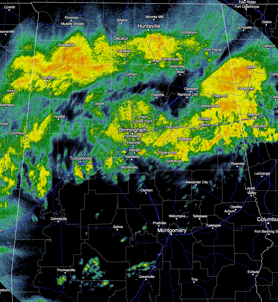
A Cloudy And Rainy Midday Out There In Central Alabama
Cloudy skies cover all of Central Alabama at this midday hour, with areas along and north of I-20 and I-20/59 receiving decent amounts of rainfall, and boy do we need it. So far at the Birmingham Airport, the total rainfall since midnight is at 0.43 inches (12:20 PM), but more is on its way as more showers and storms are expected to develop later today.
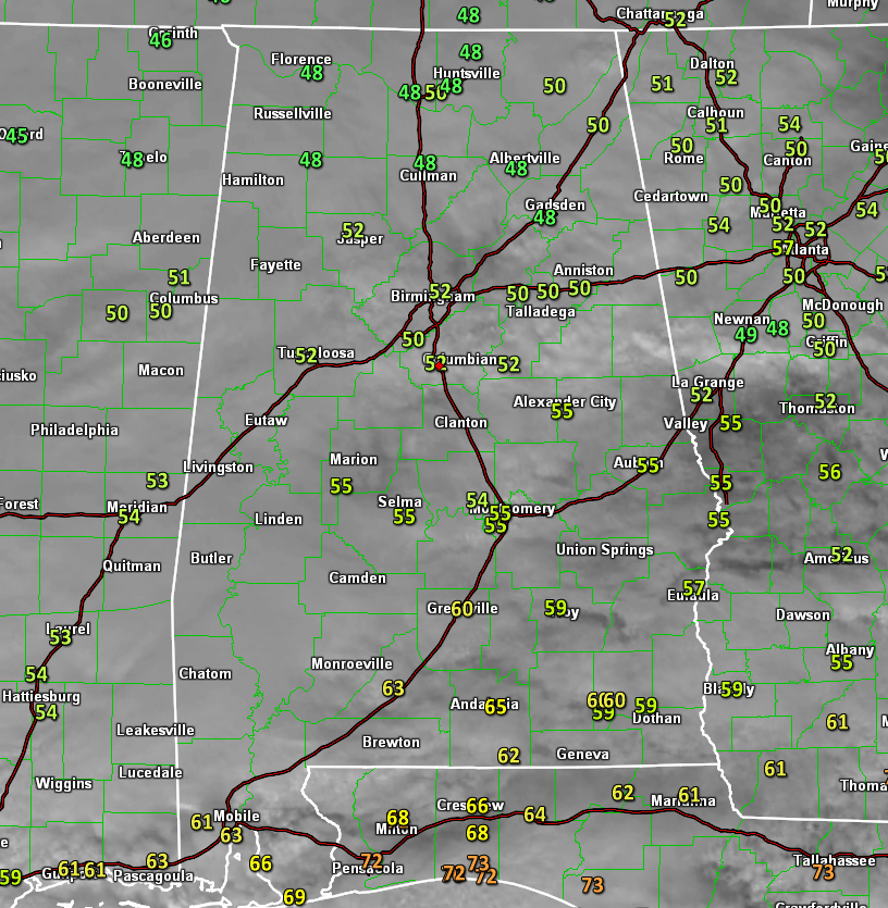
Temperatures are still rather cool at this time, with mostly 50s across Central Alabama, with a few spots in the upper 40s in the northern parts of the area. Cool spots are Cullman and Gadsden both at 48 degrees, with the warm spot being Troy at 59 degrees.
Birmingham’s Climatology And Records
The normal high for December 5th is 59, while the normal low is 37. The record high for today was set back in 1988 at 79. The record low was set back in 1907 at 21.
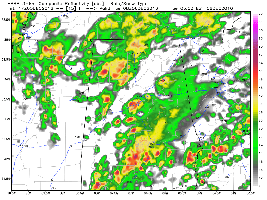
Latest HRRR Run: Simulated Radar at 2AM Tuesday
For The Rest Of Today
More showers are expected to develop across the western parts of the area and will spread northward and eastward through the day, as a warm front will move to the north ahead of a short wave moving northeastward out of northern Mexico and into Texas. There will probably be enough instability for a few flashes of lightning, but there will not be any surface-based convection during the day. Daytime highs will not be reached until midnight tonight, and they will be in the mid 50s to mid 60s from north to south.
That short wave will move rapidly to the northeast into the area during the late night and overnight hours, but depending on where the warm front makes it at that time, will determine where any strong to severe weather would happen. Any rain that falls north of the warm front should reinforce the cooler airmass, and keep instability levels lower, even though shear values will be high enough to support rotation. Also, an easterly flow will start to strengthen ahead of the warm front, as cold air damming will start to take place as ridging moves into the mid-Atlantic states.
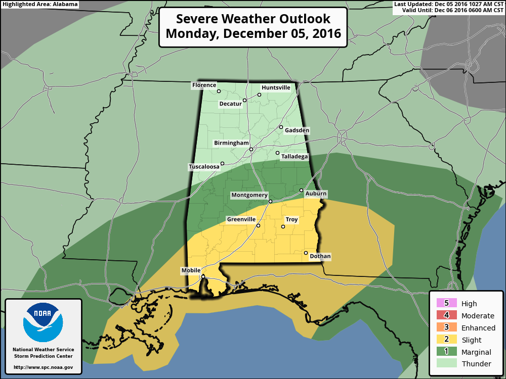
At this time, it looks like the threat of any severe weather will be located in the southern-most counties of the area, especially south of a line from Auburn to Montgomery to Coffeeville in Clarke County. The SPC have put that area in a “Slight Risk” for severe weather, with the areas north of that to a line from Wedowee to Calera to Moundville in a “Marginal Risk” for severe weather. The main threats will be from damaging winds and an isolated brief tornado due to shear and weak instability in place. Main action for stronger storms will be from about 10PM through 6AM on Tuesday morning.
Tuesday’s Outlook
Drying will start to take place for the western parts of the area early on Tuesday morning, as rainfall should come to an end by 9AM, as the short wave quickly moves to the north of the state. The rest of Central Alabama should dry out by midday. After that, skies will partly to mostly cloudy throughout the remainder of the daytime and evening hours for most of the area, with some sun possibly returning to the area south of the I-20 corridor. Afternoon highs will be in the 60s for much of the area, with a few 70s down in the southeastern part of the area. Overnight lows will mostly be in the 40s.
Number Of The Day: 15
There were 15 actual named storms in the Atlantic Basin for the 2016 Hurricane Season. Out of those 15 named storms, 7 became hurricanes, and out of those that became hurricanes, 3 became major hurricanes. Even though Matthew caused damage and major flooding in the southeastern states, we have not had a landfall from a major hurricane since Hurricane Wilma in October of 2005.
On This Day In 1886
A big snowstorm in the southeastern U.S. produced 11 inches at Montgomery AL, 18.5 inches at Rome GA, and 22.5 inches at Knoxville TN.
Follow The Blog On Twitter
Be sure to follow the Alabama Wx Weather Blog on Twitter. Just click here to start following our feed.
WeatherBrains
This is the weekly netcast that’s all about weather featuring many familiar voices, including our meteorologists at ABC 33/40. This week, the panel will be talking about water, something that we have learned to appreciate even more in the past few weeks. You can listen anytime on the web, or on iTunes. You can find it here.
Forecaster: Scott Martin (Twitter: @scottmartinwx)
Category: Alabama's Weather
About the Author (Author Profile)
Scott Martin is an operational meteorologist, professional graphic artist, musician, husband, and father. Not only is Scott a member of the National Weather Association, but he is also the Central Alabama Chapter of the NWA president. Scott is also the co-founder of Racecast Weather, which provides forecasts for many racing series across the USA. He also supplies forecasts for the BassMaster Elite Series events including the BassMaster Classic.Subscribe
If you enjoyed this article, subscribe to receive more just like it.


